The trail starts at the parking lot for Mitchel Point:

then you walk along the old highway for almost a quarter mile, then signs point you to a trail that leads to a crossing of mitchel creek.... where you cross on logs. the trail wanders out of the creekbed and back onto a paved trail which you follow another quarter mile. after that another sign points you on to the trail that leaves the highway for good. this rounds a bend and crosses a mini creek then climbs in switchbacks up some steep cliffs. after you climb maybe 5 little switchbacks the trail levels out for a while. in a little bit you come to a junction with the chetwood loop(which i returned by) then a hundred feet feet more and you come into the perham creek canyon. the trail descends into the canyon and crosses the creek on a bridge. heres a shot of perham creek where the bridge crosses:

The trail climbs gently out of the other side of the canyon which is very green and more over grown than the other side of the canyon. out of the canyon the trail shortly comes to a junction.... unsigned. the right leads to the lower viewpoint and the left leads farther up the mountain. i stopped at the lower viewpoint and took some pictures but im not done making the panoramas, so i cant post them yet.
i did make a video though... see below
heres a shot of what most of the trail looked like up to the lower viewpoint:

the trail has poison oak growing up to your knees on either side of the unmaintained thin trail. wear long pants and a longsleeve shirt and definitely bring a walking stick or poles.
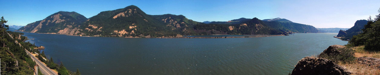
anyways... after a break i continued up the trail again. the trail comes to powerlines... and climbs under them for a few hundred feet. look up and to your left to see an osprey nest. when i was there the mother was screeching at me probably because i was too close to the nest. the section of trail that goes under the power lines is horrible. the trail is probably about 7 inches wide at most and the brush (thankfully not poison oak here) is so horribly thick. you literally just have to push through it. after that horrid section of trail the path widens out and is not very brushy as it climbs farther under douglas firs another mile up the side of the hill in switchbacks. shortly after the trail stops switching back and climbs on a straight trail, look for an obvious side trail to the right. this i took and came to an amazing upper viewpoint. its on a small out cropping maybe 7hundred feet up the gorge wall.
i took a break and took another small video. at home i put the videos of the lower and upper viewpoints together to make this: http://www.youtube.com/watch?v=fOHvWaYpwBA
so after that i continued on the other trail which led farther up the hill. i located approximately where we were on the map and continued on. two hundred yards up the trail we came to the junction with the chetwood loop again. i saw a sign that said that one way was the Wygant Trail, and below it pointed to my route and said "_____ trail" i couldnt read what the first word said but the second word was obviously trail. so i went left down the chetwood trail. this trail is really cool. you follow it a a hundred yards and come to the first of three blowdowns. this one is simbly a large log fell over the trail... but there is an easy route over/around it. then the trail comes to another area with a few smaller logs across the route, which are easily stepped over. the last one is the most difficult (though still pretty easy) to go over. i dont exactly know what happened here but some logs cover the trail then there is a five foot drop and you have to climb down it. not to bad. as you get farther into the perham creek canyon, you come to a few sections like this:

the trail gets more brushy after that and the poison oak increases. in only one place its worse than the wygant trail.
after maybe a mile of going gently down the side of perham creek canyon you come to the creek. here is a great little cascade that i got some pictures of:


you have to cross this creek but even if you dont want to get your feet wet there is a log (seen in the pictures), the route i took. the creek is not wide here so you could also jump.
the trail wanders along the creek for a while, then climbs up the side of the canyon for a litlle while. after the short climb the trail levels out and is high above perham creek. you contnue going almost level for a quarter mile then start descending at a shallow angle. it is very open forest here with not much brush. almost a mile from the creek crossing the trail comes to the area under the power lines. its just as brushy as where the wygant trail crosses. after the hundred feet that it lasts, the path dumps you out under the powerlines where its grassy and clear. (i dont know what to call that...)
well the trail doesnt just cross it. it just leaves you there. so i searched left then right. go right a hundred feet to find the trail. it goes a short ways then puts you back to the wygant trail near where it goes into the canyon. i continued back to the car.
i would reccommend that loop to any somewhat experienced hiker as long as you wear long clothes and bring a stick or poles.
i will get to making my panoramas today so i'll post them later.
length: 6 miles or so
elevation gain: 1000 feet