Laurel Hill & the Barlow Rd

This forum is used to share your experiences out on the trails.
dayhiker
Posts: 95
Joined: July 22nd, 2008, 4:48 am

Laurel Hill & the Barlow Rd

Post by dayhiker » November 11th, 2023, 11:16 am

Not sure why I decided to revisit this place, I noticed later that the trail is not in the same place as when I did it in 2009. I actually followed an abandon part which was allot shorter and not too difficult even though it was brushy.
This map shows two maps on top of one another , not sure which is the segment I did in black. I did mark where I left the trail and rejoined in GAIAGPS so maybe I will figure this out later. I think there was an uphill segment I did not take.

This was the stage Road from 1866-1925 and also the Mount Hood toll Road (wagon road 1866-1918) , not sure either followed exactly either trail, wagons I think have to go straight down or up (except maybe on a well graded road). Still one can imagine what it was like back then?

I added two red lines where approximately Chute 5 (1863-66) & Chute 4 were (1853-1856), if remember right these were abandoned after a few years use after winter rains eroded them to much to be usuable.
Another map on GAIAGPS shows a route right between these two. (I drew straight lines that seemed to be about where a diagrahm showed them to interect the curve in the road and the curve in the trail)
Screenshot 2023-11-11 at 10.02.35 AM.png
Screenshot 2023-11-11 at 10.06.43 AM.png
I actually hiked down to the highway (in 2009) from about this point , my pictures say chute 5 , but not sure of that, this photo looks back on where I came out onto the highway, there was a wagon route sign back then, before the recent construction.

Image

Image

Image

Not sure where I saw this (in 2009)
Image

dayhiker
Posts: 95
Joined: July 22nd, 2008, 4:48 am

Re: Laurel Hill & the Barlow Rd

Post by dayhiker » November 11th, 2023, 7:10 pm

I went ahead and downloaded the waypoints from GAIAGPS (maps might be copy righted) and uploaded Caltopo.

My two waypoints are on the current trail (map) which I was on anytime I looked on GAIAGPS , did not do a track.

I remember I was heading to the nearest switch back (missing the one on the trail which was quite long) but in the end started heading toward the middle of the trail below.

None of that matches any black segment, so this is something else, and the black might just be inaccurate version of the current trail? It does show the black segment going over one of the small hills and right between where there are 2 trails on the current map (one in black) on the map on my first post:
Attachments
Screenshot 2023-11-11 at 7.00.06 PM.png

dayhiker
Posts: 95
Joined: July 22nd, 2008, 4:48 am

Re: Laurel Hill & the Barlow Rd

Post by dayhiker » November 12th, 2023, 8:52 am

Oh I found a note that chute 4 crosses 26 at the truck ramp so this would be chute 5. Not sure of my source,

Where one used park for the hike, on Southside of 26, it says to drive to gravel pit (gated road now) and hike last .5 mile to meadow (end of chute 5.)

Back on 26 go East .5 mile and pull off, "Large S shaped brown swath is chute 5" don't think I came down a brown chute, but there is a picture of a straight one.

Chute 3 is the one near the historical marker(1853-1856).

Chute 2 (1849-52) is 'located entirely below the southern most section of the loop hwy. Time consuming and hazardous to find, No good viewpoint, Intact.' paraphrasing? (I didn't find) Diagram shows it spliting of from route to Chute 3, crossing West the loop highway and turning southwest and crossing the loop hwy, did not see this segment, probably lots of tree fall. Also big burn back when here? Shown as stage rd from where it turns SW to US 25 /loophighway

Chute 1 (1846-48) is 'Halfway between Mirror Lake SnoPark* and deep cut, Top is barely visible, where inside guard rail ends' paraphrase. *Or what was considered the hiking and SnoPark, not sure guard rail is there anymore did not see chute back then.

StageRd just below eastern portion of Loop Hwy - the map without 26 on it might help with this? There is pavement descending along the west (heading south here, east long term) side of 26 (unlike the Wagon Rd it did not go straight across but one might think so unless you see the pavement). I did not see this either. My recent visit I was looking for the loop hwy campground, so did not look for this or Chute 1.

RobinBaker
Posts: 25
Joined: October 6th, 2011, 1:24 pm
Location: Beaverton, OR

Re: Laurel Hill & the Barlow Rd

Post by RobinBaker » November 12th, 2023, 9:36 am

Dayhiker,

There are other more reliable sources for information about the Barlow Road on Laurel Hill than Jim Tompkins' publications. Jim's information is mostly speculation - he did not walk the "chutes" he proposed. I took a class from him in Oregon City at the Museum of the Oregon Territory in 2016 which was very informative for me at the time. Since then, I have done quite a bit of research and have hiked the Barlow Road on Laurel Hill many times, as well as Barlow Pass and Gate Creek areas.

Check these sources out (some of them may be hard to find):

1) Francis E. Williamson 1928 maps - he was a Forest Service employee and did hand-drawn maps
2) William J. "Barlow Bill" Williams (1943) - MSS 1508 at the Oregon Historical Library (document and photos)
3) Stephen Dow Beckham (1979-1995) - history professor at Lewis & Clark College:
a) Barlow Road-An Historical Study (Vol 1) - USFS – 1979
b) Barlow Road-An Historical Study (Vol 2) - USFS – 1979
c) In Their Own Words (Vol 3) Government Camp to Baker Cabin - 1993
d) The Barlow Road-An Archaeological Survey - Richard C Hanes and Stephen Dow Beckham - Overland Journal, Vol
13, No 2, Summer 1995
e) Barlow Road - Nomination Form - National Register of Historic Places -1992
4) The Barlow Road, Clackamas County, Oregon Inventory Project, Historic Context, 1845-1919, Stephen Dow Beckham
and Richard C. Hanes, August 1992 (available from the Clackamas County Planning Dept - they have a couple other
Barlow Road publications, including maps, but they don't include Forest Service land, only non-federal land in
Clackamas County)

One other comment: the MapBuilder and OpenStreetMap layers available in CalTopo will show more accurate trail locations than the USGS topographic maps found in most mapping programs. The USGS topographic map location for the Pioneer Bridle Trail is just an estimate done at the time the map was published.

Robert

dayhiker
Posts: 95
Joined: July 22nd, 2008, 4:48 am

Re: Laurel Hill & the Barlow Rd

Post by dayhiker » November 12th, 2023, 12:34 pm

Thanks

Jim is probably my source, the diagram of the loop HWY he notes is not to scale, but it also does not show the S turn it makes going East, before it was cut again by US 26, I suppose so it wasn't so cluttered.

I did find allot at the Oregon Historical Society, living in the county lets me go there free now, not sure about the library.

----
Yes I wasn't suggesting using the old map for the current location. Just wondering if it is inaccurate or if the trail has changed. At least some of it has changed as it does not seem wide enough for a stagecoach? I hiked down Barlow Butte "on the abandoned trail" (don't recommend) and found what I could see as not accurate at all, especially the switchbacks so that was what I was thinking might be the case here, probably hard to estimate without a good gps signal, and probably not much need to be accurate, just stay on the trail?

RobinBaker
Posts: 25
Joined: October 6th, 2011, 1:24 pm
Location: Beaverton, OR

Re: Laurel Hill & the Barlow Rd

Post by RobinBaker » November 12th, 2023, 1:37 pm

Perhaps some of my photos and maps will help:

https://photos.app.goo.gl/R9PB3jF2QNTVgHQG9

I have found no evidence of stagecoaches going up Laurel Hill. Stage companies always advertised in local newspapers, and I've found no advertisements for stages over Laurel Hill. There are advertisements for "stages" to resorts lower down on the mountain (such as at Welches) but this is in the 1890s and early 1900s and these were modified farm wagons, not Concord stagecoaches. The first hotel in Government Camp was in 1898 so until then, a stagecoach wouldn't have had a destination there.

There is a wagon road zigzagging up the west end of Laurel Hill. The Pioneer Bridle Trail uses a portion of this wagon road, which ends up traversing the south side of Laurel Hill to the saddle across the freeway from the Heritage Marker, being synonymous with the Pioneer Bridle Trail along here. My best estimate for the construction of this road would be 1862. Gold had been discovered in the Powder River Valley late in 1861 and people were flocking to that gold strike in the Spring of 1862. Perhaps the road company for the Barlow Road anticipated eastbound traffic going to the mines, so went to the expense of constructing the road. I've not found any documentation concerning road construction by any of the companies managing the Barlow Road, however.

Robert

Pioneer Bridle Trail Historical Information Map - Mark Beeson, ODOT - 2003 (map).jpg

dayhiker
Posts: 95
Joined: July 22nd, 2008, 4:48 am

Re: Laurel Hill & the Barlow Rd

Post by dayhiker » November 12th, 2023, 4:23 pm

Here is a good site though it does refer to Tompkins in places (which uses the same wording I quoted so that must be Tompkins).

http://columbiariverimages.com/BarlowRo ... ads_around

It says two way road 1966, faster stagecoaches.
Stage or modified wagon, not sure, either would be wider than current hiking tail in places. I think I read somewhere that they later went up, I guess, like the loop highway.

It does refer to resorts near Welchs, I think Marmot, which were a base for Mt climbing, but as you say that was much later than 1866, but before 1925? Yocum had hotel in Government Camp but much later than 1866. as well.

Sounds like you know quite a bit about this!

TompKins makes a good argument that chute 4 wasn't the only chute, but I guess chute 3 could just be a rock borrow, I think there were rope burns here as well though?

RobinBaker
Posts: 25
Joined: October 6th, 2011, 1:24 pm
Location: Beaverton, OR

Re: Laurel Hill & the Barlow Rd

Post by RobinBaker » November 13th, 2023, 7:22 am

Dayhiker,

I think a lot of your questions will be answered by the maps and photos in my Google Photo Album (link in my previous email).

Jim Tompkins' Chute 3 near the Heritage Marker on Highway 26 ("Laurel Hill Chute Loop Hike" in the OregonHikers Field Guide) is Dr. Beckham's Chute 2. Refer to the map from the Barlow Road National Register of Historic Places Nomination Form in the Google Photo album. Jim was "chute-happy" and explained and organized his narrative in terms of "chutes", as if all the descents on Laurel Hill would be similar to his Chute 3.

Pioneers may well have come down this way, but there is an easier way just to the south of the hiker's trail (#795A). This route is shown in the Google photo album by "Barlow Bill" Williams' 1943 photo. This route is visible from the hiker's trail and shows up clearly on LiDAR (the "Shaded Relief" layer in CalTopo). Barlow Bill's comments (annotated on the photo) refer to what would become Tompkins' Chute 3. It was used as a source of rock/gravel during the construction of the Mt. Hood Loop Highway in the mid-1920s. That's the reason it looks the way it does, not because of repeated pioneer wagon travel, though they would have scarred the hillside coming down.

The rock outcrop at the top of the chute is man-made (similar to the road cut rock faces along the Loop Highway at the base of the chute), not a natural rock formation. If you hike to the top of the chute and are looking down it, turn to your right (north) and walk downhill a few feet. There you'll see a natural rock formation, covered mostly with moss. When the freeway was built in the 1950s, the engineers came up this way to set dynamite to blast out the northern slope of the hill here. Their work is evident in the near-vertical rock face along the freeway below (north) of the top of the chute (east of where you park your car by the Heritage Marker).

Robert

User avatar
bobcat
Posts: 2771
Joined: August 1st, 2011, 7:51 am
Location: SW Portland

Re: Laurel Hill & the Barlow Rd

Post by bobcat » November 13th, 2023, 10:38 am

Thanks for the report and discussion!

Same place as your last photo, but from below. It is the original wagon route east of your chute 4 and just north of the Pioneer Bridle Trail, which tends to follow the 1866 stage/wagon road:

Wagon route, Laurel Hill.jpg
Wagon route, Laurel Hill.jpg (75.75 KiB) Viewed 18296 times

Section of the Territorial Stage Road, cut into the slope rather than over the crest like the Barlow Road. Maybe not an actual stage coach route but used by more sophisticated wagons that could easily make switchbacks:

Territorial Stage Road, Laurel Hill.jpg
Territorial Stage Road, Laurel Hill.jpg (74.95 KiB) Viewed 18296 times

There are several Oregon Historical Quarterly articles you could look at through JSTOR (access through your Multnomah County Library account).

dayhiker
Posts: 95
Joined: July 22nd, 2008, 4:48 am

Re: Laurel Hill & the Barlow Rd

Post by dayhiker » November 14th, 2023, 12:51 pm

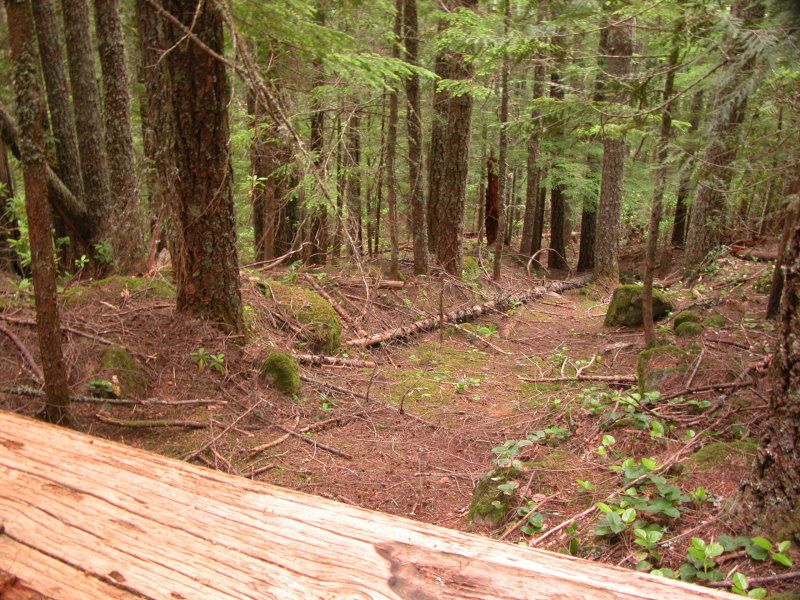
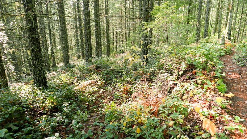
Picture from 11/23 - where I left the trail (trail on the right is darker on this site might try to lighten it):

Image

And a screenshot of part of your map:

Image

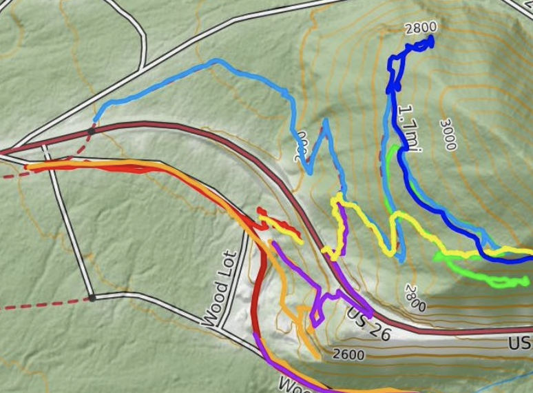
I think my photo is where your yellow route leaves the trail shown in blue(s) on the right and rejoins on the next switch back. I think I saw where the yellow left the trail again, but thought it was just a short connector to HWY 26, very close by, there is another marked trail down to 26 much further east.

I think I took a photo on my phone near here going up. I also took photo of the only really large Doug Fir, which also had a submerged fire pit, back further east, north of trail. Not worth sharing. Maybe your camp.

Allot to take in with all your info I would have guessed that they did not go on top of that one section sheer rock drop offs on south side (north of trail on the north where there are two trails) and maybe on both ends but did not check that out, your info says they did, so interesting.

I did wonder why they did not go down toward little zig-zag, but this last trip I think it might have been steeper than it looks, maybe that looked too narrow or muddy.

I did see a photo once of the hill after a fire, and thought how would anyone know where anything was!
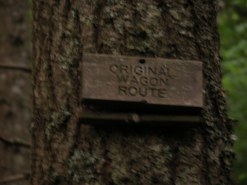
It is good folks wanted to document this before that.

Oh do you know when they made the tunnel? At the time of building the Loop Hwy? Was it to preserve the wagon road, or just a hiking/horse path?

Lots of activity above the tunnel on power lines, and least more than I remember.

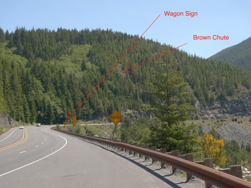
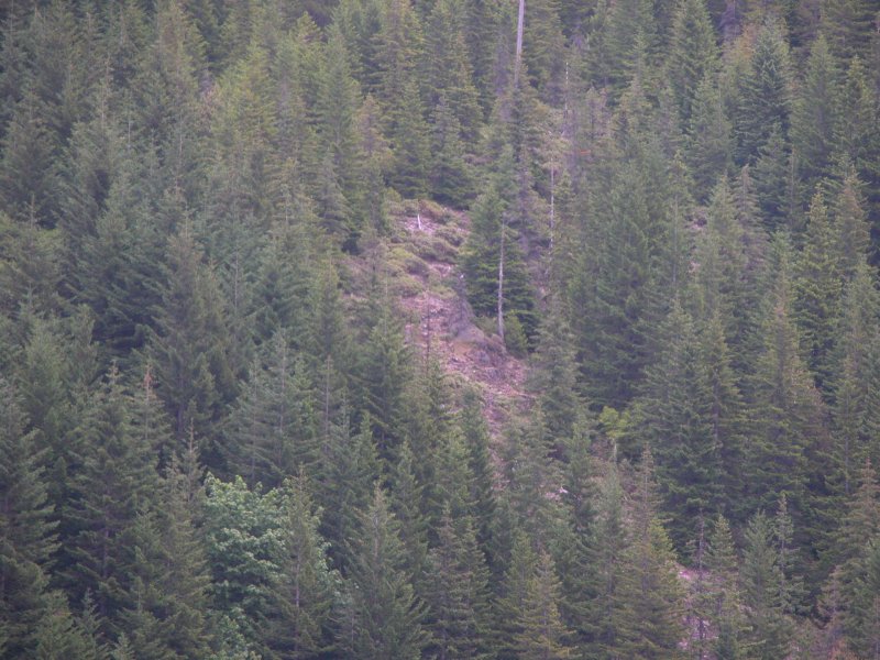
As far as chute 3 goes, back in 2009 I biked the loop road, I had planter faces[sp] and I forget now what it looks like right now but thought the chute from the loop hwy did look like a quarry. My recent time there though when I was looking for the campground I went to the top of the chute and said to myself this does look more like a chute. But I am no expert. Unless they exhausted all the rock in the quarry, it doesn't look like the one or two one sees along the Cloud Cap road. I don't know why this chute would be bare and the others have plants, maybe the amount of use, or it is a quarry, and the dirt left isn't as fertile. Or the continual erosion here is too much. The photo where he remarks about wire, does sound like maybe it isnt a chute , anyway, they did go down something like this, but it did not look like this when they did , that is why they would have abandoned it or they found something easier.

You really examined this! Thanks for sharing, and your photos do show the Tompkins diagrams I have been using, I had a few others but not nearly as easy to follow. But that doesn't mean they are correct.

Post Reply