Wizard Way (Mt. Hood Meadows) 7-17-21
Posted: July 19th, 2021, 7:13 pm
Chris A posted about the new Mt. Hood Meadows trails a few days ago, and I thought I’d add a little to the information. In general the new trails, a COVID project for the lodge’s 2020 summer staff and longtime wish of the owner, keep below the Timberline Trail. I did a loop from the main lodge to Picnic Rock and then up to Timberline, hiking west to the Umbrella Falls Trail and then back down to the lodge. However, I also decided to do a four-mile, 1700-foot EG diversion from Timberline straight up the mountain on the new Wizard Way trails (Lower Wizard Way and Middle Wizard Way).
The Lower Wizard Way is where I met a few other hikers, many of them having hiked up from the Stadium Express chairlift, which runs in the summer. The trail is well-benched, wider than the Timberline in fact, and switchbacks across ski runs and the narrow bands of mountain hemlock forest between. Bear-grass was still in bloom and the views opened up down to the Three Sisters. There was a little haze in that direction, but the skies in general were remarkably clear.
From the Mount Hood Express and Blue chairlifts, I took a jink west past a new ski patrol cabin and began the Middle Wizard Way trail, a far more interesting, untraveled, and more challenging affair although both sections of Wizard are rated the same on Meadows’ map. The trail was rubbly and uneven until I got to a bench where I met a couple who wished me “Good luck.” They pointed to a spot just above where they had lost the trail and turned around. I moseyed on up and, although I too lost the tread at a steep little scramble section where I didn’t think there should be a trail, I kept heading up and picked up the path again. In places, there are small flags and ribbons marking the route, which tells me this trail is perhaps a work in progress. Higher up, at the head of the Elevator run, there’s a bowl with a large snow bank, one of the sources of the East Fork Hood River.
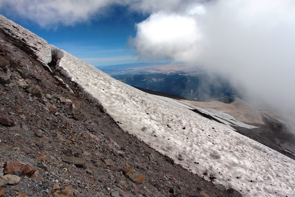
Off to the right I was able to stare down the lateral moraine of the Clark Glacier to the terminus of that tongue under stark buttresses. The trail then climbed a rough route and traversed below a gnarly prominence that I’ll call Wizard Head. Again I lost the route emerging from krummholz outcrops of whitebark pine but picked up a couple of flags in the stark tundra above. These led me above Meadows’ highest chairlift, the Cascade Express, in a big switchback to the crest of Wizard Head at about 7,600 feet.
Wizard Head is the terminus of the Middle Wizard Way, but what of Upper Wizard Way? It must have been part of the concept, but it’s not on their new map. I suspect it would head higher up bare ridges in a sandy slog to the edge of wilderness and the Meadows permit area at 9,000 feet or so, a new high alpine sibling of the Mountaineer, Barrett Spur, and Cooper Spur trails.
The Lower Wizard Way is where I met a few other hikers, many of them having hiked up from the Stadium Express chairlift, which runs in the summer. The trail is well-benched, wider than the Timberline in fact, and switchbacks across ski runs and the narrow bands of mountain hemlock forest between. Bear-grass was still in bloom and the views opened up down to the Three Sisters. There was a little haze in that direction, but the skies in general were remarkably clear.
From the Mount Hood Express and Blue chairlifts, I took a jink west past a new ski patrol cabin and began the Middle Wizard Way trail, a far more interesting, untraveled, and more challenging affair although both sections of Wizard are rated the same on Meadows’ map. The trail was rubbly and uneven until I got to a bench where I met a couple who wished me “Good luck.” They pointed to a spot just above where they had lost the trail and turned around. I moseyed on up and, although I too lost the tread at a steep little scramble section where I didn’t think there should be a trail, I kept heading up and picked up the path again. In places, there are small flags and ribbons marking the route, which tells me this trail is perhaps a work in progress. Higher up, at the head of the Elevator run, there’s a bowl with a large snow bank, one of the sources of the East Fork Hood River.
Off to the right I was able to stare down the lateral moraine of the Clark Glacier to the terminus of that tongue under stark buttresses. The trail then climbed a rough route and traversed below a gnarly prominence that I’ll call Wizard Head. Again I lost the route emerging from krummholz outcrops of whitebark pine but picked up a couple of flags in the stark tundra above. These led me above Meadows’ highest chairlift, the Cascade Express, in a big switchback to the crest of Wizard Head at about 7,600 feet.
Wizard Head is the terminus of the Middle Wizard Way, but what of Upper Wizard Way? It must have been part of the concept, but it’s not on their new map. I suspect it would head higher up bare ridges in a sandy slog to the edge of wilderness and the Meadows permit area at 9,000 feet or so, a new high alpine sibling of the Mountaineer, Barrett Spur, and Cooper Spur trails.
 [/url]