We started out at the “top” which is Miller Lake/Digit Point campground after leaving a car at Swiftwater. The Miller lake to Maidu lake is for some reason not part of the official North Umpqua trail, so add those ~5.5 miles to your total distance if you are hiking the whole thing. We did this hike late July 2020.
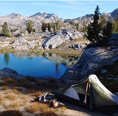
From Miller lake to Maidu you climb through boggy mosquito-ey area (bring your headnet this time of year!) At Maidu lake you get a view of Mt Bailey and a lot of bugs. We didn’t see any great campsites but we only went around the east side of the lake to see the outlet that is the beginning of the North Umpqua River which is kind of neat to know the river from its tiny source. We hiked another couple of miles near Lake Lucile because it was getting dark and found a nice campsite next to a stream which is (I believe) the first tributary of the N umpqua river.
The next day we hiked the rest of the Maidu section which is almost all downhill out of the cascades and saw zero people. We hit a road and then started the Lemolo section. This section is not that nice. It’s next to forest service roads so you can hear some traffic and there are some burns you walk through. All in all it’s just kind of ok. There are no campsites along this section. There is also little water. We got off trail to go to the inlet of lemolo lake to get water and have dinner. There is a campground there called Inlet you could stay at. We didn’t and got back on trail. That night we crossed a road at the end of the reservoir and started down the Dread and Terror section. We were afraid we wouldn’t find a place to camp before dark but fortunately we found a little shelf next to the river.
The beginning of dread and terror is well maintained and has some beautiful waterfalls and good campsites. The rest of dread and terror took us all of the next day. There were (according to a trail crew we ran into) 160 blow downs on this section and I think that sounds about right. Going over and under so many trees took forever. I believe they are currently working on logging this section out. It will be awhile! Toward the end of dread and terror the section (right before hot springs) lived up to its name when the trail was washed out 3 separate times in terrifying crossings where you had to walk on a cliff ledge with the trail almost completely gone. One slip and you would fall either down a cliff to your death or into the river (also probably to your death as it was raging). I would not recommend anyone do this until they fix it. Someone is going to get hurt or honestly someone could die on these wash outs. It’s no joke to navigate these with a backpack on. We ran into a mountain biker later who said he guides this trail and has seen people cry and freak out when faced with these wash outs. I don’t know how long they’ve been there but it’s really irresponsible to not fix them and provide no warnings or signs. I informed the trail crew leader when we got back and I hope they fix this. We got through that after I had a minor mental breakdown about how scary it was and almost turned back. We got to umpqua hot springs where there are several nice dispersed campsites (both before and after the hot springs parking lot) and used the springs which we were told were closed due to Covid but the ranger said we could so-? There were plenty of people there for “closed” springs but not at very early morning hours. As you get near the hot springs you can tell the trail gets a lot more use as there are a couple beautiful waterfalls and it’s an easy hike from the hot springs parking lot. Unfortunately more people means a bunch of toilet paper and gross trash. There is a pit toilet at the trailhead but it was out of order. There is another heavily graffiti covered pit toilet closer to the springs.
As is usual for Oregon hot springs these days people were up there partying - drinking and high. Some people were camped out possible long term in the parking lot and an exhausted ranger was trying to get people to clear out.
Next we hiked the hot springs section which is beautiful old growth and knot the Deer Leap. Deer leap is very pretty but there is very little water until the end, so plan accordingly. We thought there was a trail from there down to tokatee falls but there wasn’t so we missed it
Around this point you start seeing a LOT of poison oak. It is everywhere and growing over the trail. Leaving the trail from about the middle of deer leap on down would have you waking though it at least thigh deep. Don’t do what I did and only have shorts. Bring gaitors and or long pants. Definitely bring technu to wash yourself a couple times a day.
The next day was pretty rough. The Wright, marsters and calf sections are all on the other side of the North Umpqua river from highway 138 so there’s that. But all of them have been burned to some degree so they are hot and exposed and you are walking on rocks most of the time. Even though these 3 sections are only like 11 miles, we were exhausted at the end. There is a lot of up and down On this trail and the rough tread really wears you down. There was also a couple more scary wash outs where the trail is gone above a cliff. There is zero camping on trail here. In fact I could say there is zero camp sites along any section except dread and terror. Dread and terror is 13 miles long and has a lot of nice campsites all along it. But zero in the other sections. There is only camping in between sections really either at campgrounds or dispersed along roads or like in boulder creek wilderness. We ended up camping under a bridge at a little dispersed site right at the end of the calf section before it meets a road. There is a pit toilet there, which is a bonus.
The next day was easier. We did panther before 11 am. One nice thing is when you end the panther section you come out at a historic bridge and there’s a pit toilet and - even more exciting- a spigot and drinking fountain. We filled up and washed some things. The other exciting thing at this trailhead is a dumpster. It’s really nice to get rid of your 3-4 days of trash so you don’t have to carry it the whole hike - ha. This is the steamboat area and there is a very nice (& expensive) lodge and restaurant etc. if someone were so inclined they could treat themselves to this halfway through their hike. We didn’t go to it since you’d have to cross the bridge and walk on the road. We only saw the lodge from the trail across the river. After taking advantage of these civilized amenities in between panther and Mott, we finished Mott section before early afternoon. Both have very nice tread, pretty forest and not a ton of elevation gain. Those 10.5 miles were pretty easy. So we decided to continue on even though there is a nice campground right when you finish Mott. I recommend the “old growth interpretive” loop at the end of Mott. Also another pit toilet lol. The only bad thing about Mott was I got stung by a hornet that got stirred up on the trail.
Continuing on that day we started tioga. Yet another burn. Every day on this trail we went through at least one burn. It was very hot but there were quite a few streams so water wasn’t a problem. We saw one possible campsite about 3 miles in but we wanted to do more miles. Surely there would be other campsites on this almost 16 mile stretch?
We continued on tioga until the burn ended and it becomes beautiful old growth again. But you still can’t go off trail not even to go to the bathroom because there is soooo much poison oak everywhere. We were about 8 miles in and deciding we were not going to see any sites and not about to make a site by clearing out poison oak, we slept on a bridge over a creek. A fire pit under the bridge told us someone else had the same idea. Since the entire almost 90 miles we only saw 2 other hikers (Going the opposite way and only doing 3 sections) and 1 mountain biker, we weren’t concerned that we’d be in someone’s way in the middle of the night. All in all sleeping on a bridge is pretty sweet
The next day we finished the other 10 miles of tioga. There is a big climb up and down a peak on this last part. This last section has so so so much poison oak and you can not avoid touching it with your legs so I again stress that you have pants and bring technu. On the last 2-3 miles before swiftwater there is yet another recent burn. We saw a few dayhikers and trail runners when we were close to the end. We finished at swiftwater (another out of order pit toilet) and headed home.
All in all this was a fun adventure. You only see people when you end a section on a road or campground area. During normal times I suppose you could get a campground spot but this year they are all reservation only. You don’t need a permit or pass to park at any trailhead. I recommend calling the ranger station in advance to get a trail report and make sure all the sections are open. We got lucky and had one section open right before we went. This is not a wilderness experience as you are near a highway and can hear road noise almost the entire time except a few times when you are back a ways from the road. But it is a beautiful hike and you get to see so many different kinds of Oregon forests and ecosystems from oak savannah to old growth hemlock to cascades pines. I recommend it if you are looking for a challenge that offers solitude and a “thru hike” type experience. All in all we probably did about 88 miles and it took us 6 days.


 Fortunately with the trail being so uncrowded you don’t need to worry so much about being way off trail to do that. When we got done hiking I had little spots from it that cleared up in a couple of days and didn’t even itch. My mosquito bites were worse! But I know some folks who those little spots would have turned into a giant rash so those people shouldn’t hike in...well, basically all of southern Oregon (ha) as I’ve found the stuff is just everywhere down there!