Fish Creek Mountain

This forum is used to share your experiences out on the trails.
Post Reply
User avatar
Don Nelsen
Posts: 4381
Joined: May 28th, 2008, 10:03 pm
Location: Vancouver, WA

Fish Creek Mountain

Post by Don Nelsen » August 19th, 2020, 5:59 pm

Image

This one was completely off my radar since the maps I have don’t show a trail and I simply didn’t take time to research it. Kelly asked me about it and said she thought there was a trail so, after a little guide book research, sure enough, a trail. To top it off, a very nice trail, hardly any rocks and only a dozen fallen trees to step over or duck under. Nice. Also, lots of really picturesque old-growth to admire and views of Jefferson, Hood and the even the Sisters (though you have to work to get that.)

The trail starts out with 6/10 of a mile through an ancient old-growth grove then transitions to an abandoned logging road for the next 4/10 mile. After that, it’s a delightful ridge hike, sometimes on an almost knife edge too.

Image

Image

Image

Image

Image

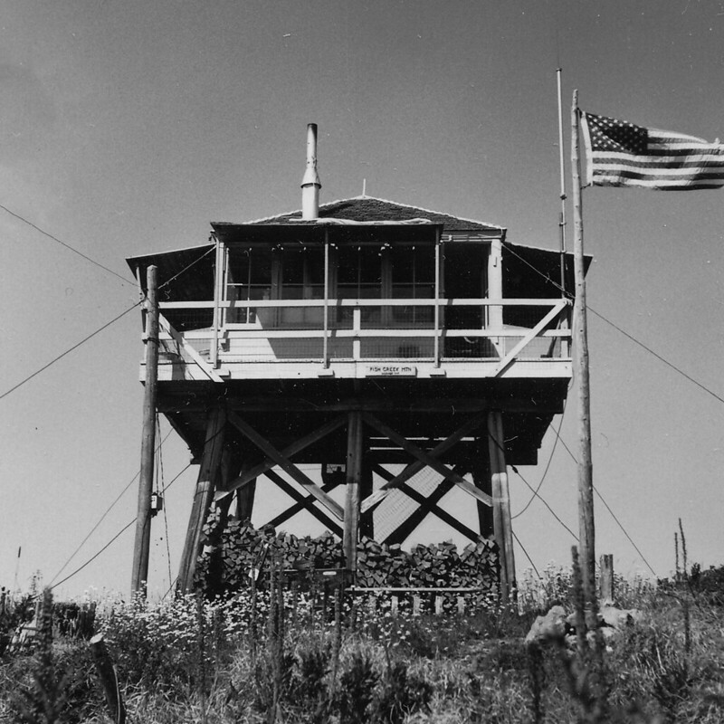
The summit once hosted a fire lookout, now removed and near there is a rocky outcrop, good for taking a lunch break or just enjoying the ambiance.

On the way back, to round out the day I did a short bushwhack along a ridge adjacent to the trail to see if I could get some better views. I found a spot at the southern end, but alas, nothing I couldn’t see from the regular trail.
An easy hike, only a few short steep spots and then there’s those trees to step over, but easy enough.

6.7 miles RT, 2,268’ EG

The map:
Image

Directions:
Take Hwy 224 through Estacada and turn right on forest road 4620 at MP 45.8. Follow this for 7.7 miles, paved at the start, then gravel, and park on the left. TH is on the right of the parking area. Room for a half dozen cars or so.
"Everything works in the planning stage" - Kelly

"If you don't do it this year, you will be one year older when you do" - Warren Miller

User avatar
RobFromRedland
Posts: 1095
Joined: May 28th, 2008, 10:03 pm

Re: Fish Creek Mountain

Post by RobFromRedland » August 19th, 2020, 10:09 pm

Don, there is more info on the TrailAdvocate page here: https://www.trailadvocate.org/trails/541-2/

That first section is a segment of the old Cold Springs trail that takes you up to the old road that was abandoned after the '96 floods. The original trail was shorter (just the spot where it takes off between the two old roads).

Looks like there is some new logs down - last time I hiked it, it was pretty much clear of logs, but last winter was a tough winter for downed logs.

The side trip down to high lake is highly recommended as well. High lake is a really cool alpine lake.
Life is not a journey to the grave with the intention of arriving safely in a pretty and well-preserved body, but rather to skid in broadside, thoroughly used up, totally worn out, and loudly proclaiming: WOW! What a ride! - Hunter S. Thompson

justpeachy
Posts: 3068
Joined: May 28th, 2008, 10:03 pm
Location: Portland, OR
Contact:

Re: Fish Creek Mountain

Post by justpeachy » August 20th, 2020, 6:11 am

That's a nice hidden gem. We did it back in 2014 and were pleasantly surprised by what a nice hike it was. Nice wildflowers in June.

At the National Archives in Seattle I found a photo of the lookout that I included in my book. As with many of these lookout sites, it looked WAY different back then without all the trees grown up!

Image

It's in the Field Guide, if anyone wants more info on the route: https://www.oregonhikers.org/field_guid ... ntain_hike

User avatar
TwoPaw
Posts: 113
Joined: July 28th, 2013, 10:30 am
Location: Portland

Re: Fish Creek Mountain

Post by TwoPaw » August 20th, 2020, 6:13 am

Don Nelsen wrote:
August 19th, 2020, 5:59 pm
Take Hwy 224 through Estacada and turn right on forest road 4620 at MP 45.8. Follow this for 7.7 miles, paved at the start, then gravel, and park on the left. TH is on the right of the parking area. Room for a half dozen cars or so.
What's the road like? FS Interactive calls it a Low Standard, meaning High Clearance Only. Is it really that bad? I've been wanting some new areas to explore.

Looking at the map it would be neat to connect a trail down to Indian Henry campground.

User avatar
RobFromRedland
Posts: 1095
Joined: May 28th, 2008, 10:03 pm

Re: Fish Creek Mountain

Post by RobFromRedland » August 20th, 2020, 6:59 am

TwoPaw wrote:
August 20th, 2020, 6:13 am
What's the road like? FS Interactive calls it a Low Standard, meaning High Clearance Only. Is it really that bad? I've been wanting some new areas to explore.

Looking at the map it would be neat to connect a trail down to Indian Henry campground.
I don't recall any significant washouts or anything - my recollection is that it is a pretty standard FS gravel road that gets light use.

Connecting a Trail down to Indian Henry would be quite difficult I think - that is steep country and much of it has been thinned in the last several years, meaning the underbrush has grown up quite a bit. Not easy walking.
Life is not a journey to the grave with the intention of arriving safely in a pretty and well-preserved body, but rather to skid in broadside, thoroughly used up, totally worn out, and loudly proclaiming: WOW! What a ride! - Hunter S. Thompson

User avatar
Don Nelsen
Posts: 4381
Joined: May 28th, 2008, 10:03 pm
Location: Vancouver, WA

Re: Fish Creek Mountain

Post by Don Nelsen » August 20th, 2020, 7:52 am

I agree with Rob - pretty standard for such roads. Minor potholes in a few spots but nothing even a low clearance car couldn't handle easily. Looking back at my GPS track, I drove the 7.7 miles in 22 minutes at an easy, safe pace.
"Everything works in the planning stage" - Kelly

"If you don't do it this year, you will be one year older when you do" - Warren Miller

User avatar
Don Nelsen
Posts: 4381
Joined: May 28th, 2008, 10:03 pm
Location: Vancouver, WA

Re: Fish Creek Mountain

Post by Don Nelsen » August 20th, 2020, 7:56 am

RobFromRedland wrote:
August 19th, 2020, 10:09 pm
Don, there is more info on the TrailAdvocate page here: https://www.trailadvocate.org/trails/541-2/

That first section is a segment of the old Cold Springs trail that takes you up to the old road that was abandoned after the '96 floods. The original trail was shorter (just the spot where it takes off between the two old roads).

Looks like there is some new logs down - last time I hiked it, it was pretty much clear of logs, but last winter was a tough winter for downed logs.

The side trip down to high lake is highly recommended as well. High lake is a really cool alpine lake.
Hi Rob,

Thanks for the comment and the info. I'll check that lake out next time I'm in the area.

dn
"Everything works in the planning stage" - Kelly

"If you don't do it this year, you will be one year older when you do" - Warren Miller

leiavoia
Posts: 232
Joined: April 24th, 2015, 9:53 pm

Re: Fish Creek Mountain

Post by leiavoia » August 20th, 2020, 8:48 am

I agree on the lake. It would be a sort of ho-hum hike without it. I camped there on the 4th of July a few years back and had it all to myself, and 1.2 billion mosquitoes.

The summit was overgrown when i was there last there and i didnt get much of a view either.
IMG_4179-IMG_4293_blended_fused_s.png

Post Reply