South Burnt Lake 772 to Zigzag Ridge - Bad Road
I thought things would improve at the top of the incline when the road levels off as it turns sharply east. Actually, without drainage, it got worse with a giant mudholes of questionable depth. I decided not to push it, parked amongst a handful of shotgun shells and a Red Bull can, and walked the last two plus miles to the trailhead. This road is really only suitable for a true high clearance 4WD, a marked decline since I last drove it two decades ago. There's clearly some dispersal camping/partying going on up there with rutted out side roads. Still, it was a pleasant enough with roadside roadies in full bloom.
The actual trailhead was deserted. Three fire rings around the perimeter define its more current use. On the trail itself some blowndown but since the beginning of 772 is actually an old road, there's plenty of room to work around it. 
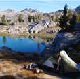
The hike itself was great. Little streams gurgling out of the hillside everywhere. Lot's of trillium out now and the flowers should get better. Some mosquitoes and I imagine that will get worse before it gets better. View from Zigzag always a treat, and actually much better than two decades ago as numerous clearcuts are growing back in - restoring carpet like tree cover. Only Lolo Pass road provides a harsh exception now. Lots of horseflies at the actual lookout - I actually love the evolving views along the ridge better - and great wildflowers up there. Chatted briefly with the only other hiker I saw all day. Descended back via Devil's Tie in. More flowers and rushing water.
Re: South Burnt Lake 772 to Zigzag Ridge - Bad Road
My first experience on that road was walking down on a loop hike, so the first time I decided to drive up, I pretty much knew I wouldn't make it all the way. I gave up at the spot you describe above, partly because I knew there were mud bogs to deal with anyway. That's probably the worst-drained FS road I've encountered.TwoPaw wrote: ↑June 20th, 2020, 6:58 amThe steep hill after the first switchback onto gravel required a slow, s-l-o-w crawl up a steep incline (passenger sedan) with few turnouts and even fewer turnarounds. Amazingly, nothing scraped.
I thought things would improve at the top of the incline when the road levels off as it turns sharply east. Actually, without drainage, it got worse with a giant mudholes of questionable depth.
edit: I was thinking of road 27. What's this "Forest Road 2627(-207)"? (I'm pretty sure we're talking about the same road.)
Re: South Burnt Lake 772 to Zigzag Ridge - Bad Road
Well now that's just crazy. I don't remember seeing that sort of naming scheme on FS roads before.
Thanks Webfoot.
I just had a funny memory of that road. I mentioned above I once walked that road. I recall it was raining, but I couldn't understand how that could be, because my memory of the hike was cold and dry, no clouds, no weather anxiety, no precip or clouds in forecast. I remember now, it was snow melting out of the trees.
Re: South Burnt Lake 772 to Zigzag Ridge - Bad Road
It is Road 27 to start. As you leave Rhododendron driving east there are a series of numbered roads that mainly lead to FS Homesites (long term leases on cabins, little houses). So in typical green corner signs you see Road 25, 26, 27...
My guess Road 27 morphs to 2627 (or is the same as 2627 and morphs to 207) when it becomes gravel at the sharp turn uphill. Since so many FS roads no longer have markings it's a little academic. I'm thinking there are a series of old logging roads and 2627-207 happens to go to a trailhead and since there is no active logging the FS isn't going to worry about them. The first time I ever tried to take this road - in 1996 - it was closed due to logging activities. The road used to go all the way to Devils Meadow and the mosquito infested campground there. From there you could ride your motor scooter up to Zigzag, I'm guessing.
For my money it would seem to make sense to gate 2627-207 and create a new trailhead at the bottom of the hill if you're not going to maintain the road beyond. Walking 2627-207 towards the trailhead it appears some of the land on the south side of the road is private and there is one gated road with No Trespassing signs. That might be part of the story.
- OregonSurveyor
- Posts: 54
- Joined: August 6th, 2011, 11:21 am
- Location: SE Portland (Hawthorne district)
Re: South Burnt Lake 772 to Zigzag Ridge - Bad Road
Not to beat the road numbering convention to death, but...
TwoPaw all of those 2-digit cabin roads, are technically preceded with 26, even as they originate along US26. I’ve asked several folks at the USFS if the 26 relates to US26 and our conclusion is that it does NOT. The numbering convention actually started when it was Hwy 50.
There is still a Rd2613 sign where RD 13 begins.
Also that private land on Rd 27 is an old Homestead tract that was owned by a spinster schoolteacher, today it is owned Simon Burke of Simon’s Tree Service.
Jerry King
Oregon Land Surveyor (Retired)
SAR Volunteer - CSAR (Clackamas County Sheriff)
Oregon Land Surveyor (Retired)
SAR Volunteer - CSAR (Clackamas County Sheriff)
-
- Posts: 3068
- Joined: May 28th, 2008, 10:03 pm
- Location: Portland, OR
- Contact:
Re: South Burnt Lake 772 to Zigzag Ridge - Bad Road
That road is notoriously bad, and has been for a long time. I figure the Forest Service wants to have it as emergency access in case of wildfire, but why they don't gate it the rest of the time is a mystery.
Re: South Burnt Lake 772 to Zigzag Ridge - Bad Road
Hey now, that general area is already hard enough to access. Please don't encourage them to close that road too, no matter how much of a mess it is.justpeachy wrote: ↑June 22nd, 2020, 6:35 amThat road is notoriously bad, and has been for a long time. I figure the Forest Service wants to have it as emergency access in case of wildfire, but why they don't gate it the rest of the time is a mystery.
- retired jerry
- Posts: 14424
- Joined: May 28th, 2008, 10:03 pm
Re: South Burnt Lake 772 to Zigzag Ridge - Bad Road
Yeah, terrible road, a couple years ago
What do you think of that dirt tube? I've been trying to figure them out for years. They always are around after snow melts. I think a tunnel melts out under the snow, by a little stream, which then carries a bunch of gravel to fill tunnel. Then the snow all melts leaving the dirt tube
Re: South Burnt Lake 772 to Zigzag Ridge - Bad Road
Pocket gophers?retired jerry wrote: ↑June 24th, 2020, 5:44 pmWhat do you think of that dirt tube? I've been trying to figure them out for years. They always are around after snow melts. I think a tunnel melts out under the snow, by a little stream, which then carries a bunch of gravel to fill tunnel. Then the snow all melts leaving the dirt tube
https://gf.nd.gov/wildlife-notes/dirt-tubes
https://www.volecontrol.com/file/gopher-mud-cast
http://www.stormeffects.com/co_wildflow ... _butte.htm
Voles make something a little different.
https://www.domyown.com/vole-inspection ... a-618.html