Newton Clark Ridge/Moraine, 8/31/19
Posted: September 3rd, 2019, 2:16 pm
I haven't been up to Mt. Hood at all yet this year, so on Saturday I decided to hike up Newton Clark Ridge. (This is not its official name, but it's between Clark Creek and Newton Creek, and below Newton Clark Glacier. Skiers sometimes call it "Pea Gravel Ridge.") I was there once before, more than ten years ago, but I wanted to go a little farther this time, and the weather was better.
I started from the main Mt. Hood Meadows parking lot and worked my way up service roads and deer paths to the Timberline Trail. Most of the flowers finished pretty early this year; at this point it was mostly pearly everlasting, goldenrod, and one or two kinds of asters.
Descending into Heather/Clark Canyon, I got a side view of the ridge. Note that a landslide forced a rerouting of the Timberline Trail coming up from Clark Creek:
From the bottom, there's a nice morning view up the mountain:
Just to be different, I decided to go straight up the side of the moraine instead of picking up the crest where it crosses the Timberline Trail. I'm not completely insane though; I at least waited until I got to a section that was covered in manzanita. Still an awfully steep (and loose) climb up to 6100' though.
Once on top of the ridge, there's not much guesswork about where to go. Just a steady climb up the crest:
There's a nice view down to the waterfalls on Clark Creek:
And an ever better view of the amazing waterfalls that come down the southwest side of Gnarl Ridge ("Newton Creek Falls," according to waterfallsnorthwest.com):
Between 7400' and 7500', there are three "gendarmes" on the ridge. I hesitate to use that term, because they're not all that big, but they do present a challenge. The first one is big, but not too much trouble; you can inch your way around it on the south side or just climb right over the top:
The second one is tricky because the ridge slopes away very steeply on either side. This time, I clung to the north side:
The third one is much smaller, but it's the worst. The ridge on the downhill side is a knife-edge of sand and rocks that aren't even remotely glued down. On the way down, I ended up scooting on my butt for about ten feet after getting past the big boulder. (And I don't even remember whether I went to the right or left side.)
After that, it was relatively smooth sailing. Down to the left, there were some cool-looking hanging gardens (mostly monkeyflower, I'm guessing) that would be an enormous pain to get to:
The best close-up views of the mountain were from just past the gendarmes; as I got closer, the summit started hiding behind the nearer cliffs. Here's one where you can still see everything:
In the next photo, you can see where the light gray broken moraine material ends and gives way to pinkish solid (or what I thought was solid) rock. I decided to scramble up a little further, and kinda regretted it; the rock was absolutely horrible. 50% of the holds I tried came right out in my hand. Good thing no one was below me!
Once I got up onto bigger chunkier talus, it wasn't so bad. I topped out just above 8000' and hung out at the base of the gray cliff for a while (is this the feature that Chip Down calls the "Newton Clark Prow"?). Here's a view of the cliff bands above Gnarl Ridge:
...and a shot of the summit and Newton Clark Glacier:
Some really cool clouds were forming and then disappearing in the lee of Hood's summit, so I shot about 20 minutes of time-lapse video. I ended up doing this twice more, once near Clark Creek and once in the parking lot at the end of the day; here's the result:
And then it was time to head back down — which turned out to be much trickier than going up, since gravity was now conspiring with my feet to dislodge rocks and try to send me hurtling down the moraine...
This time I went the "normal" way and continued down the ridge until I found the Timberline Trail and the Mt. Hood Wilderness sign. (Newton Clark Ridge is the boundary between the wilderness and the ski area for its entire length.) There's no actual trail through the wooded section of the ridgecrest, but it's fairly open and I only had to dodge one or two fallen trees.
I couldn't believe how many tourists I passed on my way out; apparently it's a thing to take the Stadium Express lift up from the MHM main lodge and then hike down to see the Heather Canyon waterfalls.
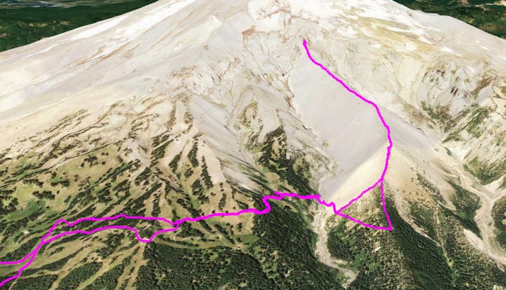
Google Earth view of my route:
I started from the main Mt. Hood Meadows parking lot and worked my way up service roads and deer paths to the Timberline Trail. Most of the flowers finished pretty early this year; at this point it was mostly pearly everlasting, goldenrod, and one or two kinds of asters.
Descending into Heather/Clark Canyon, I got a side view of the ridge. Note that a landslide forced a rerouting of the Timberline Trail coming up from Clark Creek:
From the bottom, there's a nice morning view up the mountain:
Just to be different, I decided to go straight up the side of the moraine instead of picking up the crest where it crosses the Timberline Trail. I'm not completely insane though; I at least waited until I got to a section that was covered in manzanita. Still an awfully steep (and loose) climb up to 6100' though.
Once on top of the ridge, there's not much guesswork about where to go. Just a steady climb up the crest:
There's a nice view down to the waterfalls on Clark Creek:
And an ever better view of the amazing waterfalls that come down the southwest side of Gnarl Ridge ("Newton Creek Falls," according to waterfallsnorthwest.com):
Between 7400' and 7500', there are three "gendarmes" on the ridge. I hesitate to use that term, because they're not all that big, but they do present a challenge. The first one is big, but not too much trouble; you can inch your way around it on the south side or just climb right over the top:
The second one is tricky because the ridge slopes away very steeply on either side. This time, I clung to the north side:
The third one is much smaller, but it's the worst. The ridge on the downhill side is a knife-edge of sand and rocks that aren't even remotely glued down. On the way down, I ended up scooting on my butt for about ten feet after getting past the big boulder. (And I don't even remember whether I went to the right or left side.)
After that, it was relatively smooth sailing. Down to the left, there were some cool-looking hanging gardens (mostly monkeyflower, I'm guessing) that would be an enormous pain to get to:
The best close-up views of the mountain were from just past the gendarmes; as I got closer, the summit started hiding behind the nearer cliffs. Here's one where you can still see everything:
In the next photo, you can see where the light gray broken moraine material ends and gives way to pinkish solid (or what I thought was solid) rock. I decided to scramble up a little further, and kinda regretted it; the rock was absolutely horrible. 50% of the holds I tried came right out in my hand. Good thing no one was below me!
Once I got up onto bigger chunkier talus, it wasn't so bad. I topped out just above 8000' and hung out at the base of the gray cliff for a while (is this the feature that Chip Down calls the "Newton Clark Prow"?). Here's a view of the cliff bands above Gnarl Ridge:
...and a shot of the summit and Newton Clark Glacier:
Some really cool clouds were forming and then disappearing in the lee of Hood's summit, so I shot about 20 minutes of time-lapse video. I ended up doing this twice more, once near Clark Creek and once in the parking lot at the end of the day; here's the result:
And then it was time to head back down — which turned out to be much trickier than going up, since gravity was now conspiring with my feet to dislodge rocks and try to send me hurtling down the moraine...
This time I went the "normal" way and continued down the ridge until I found the Timberline Trail and the Mt. Hood Wilderness sign. (Newton Clark Ridge is the boundary between the wilderness and the ski area for its entire length.) There's no actual trail through the wooded section of the ridgecrest, but it's fairly open and I only had to dodge one or two fallen trees.
I couldn't believe how many tourists I passed on my way out; apparently it's a thing to take the Stadium Express lift up from the MHM main lodge and then hike down to see the Heather Canyon waterfalls.
Google Earth view of my route: