First tracks (in a month) on Defiance - 3/15/19
Posted: March 16th, 2019, 12:08 pm
Third time is the charm, as they say.
Ben and I got a DN-style alpine start from the Starvation TH at approx 10am, because "someone" (hint: it wasn't me) forgot their boots and we had to drive back to Portland from Cascade Locks before driving back to the TH...
I was last here on 3/2/19, so basically two weeks ago, and the conditions are very different. I believe the weather decided it was officially "spring" when the clocks changed last week. All the lower elevation snow is going to be gone in a few days.

Dog appears to have already melted out below Puppy Dog.

Lancaster is no longer frozen.

For reference, this was 2 weeks ago at Lancaster:

It was hard to tell if people went up last weekend due to the consolidation and melt of the snow. We really only saw one set of prints heading up; this "bench" I think is actually the result of newer snow melting out around the more solidified track from a month ago.

The track continued around onto the switchbacks past the 1300 ft road junction, but we opted to go up the Direttissima.

Same spot 2 weeks ago:

About the spot where Shop and I turned around last time. It was covered with unconsolidated powder and all the trees were covered in hoarfrost. Ch-Ch-Ch-Changes...

The other tracks joined the Direttissima but stopped at around the 1600-1700 ft mark. After this, it appeared no one had been up the Defiance side since I last tried on 2/18/19. That day the trail was broken to about 2300 ft and I broke from there to 3800 ft before turning around. Not sure when the last time someone actually made it to the summit was. I would consider it possible but unlikely that someone could have summited via Starvation if no one had summited via the Defiance side during the same period.
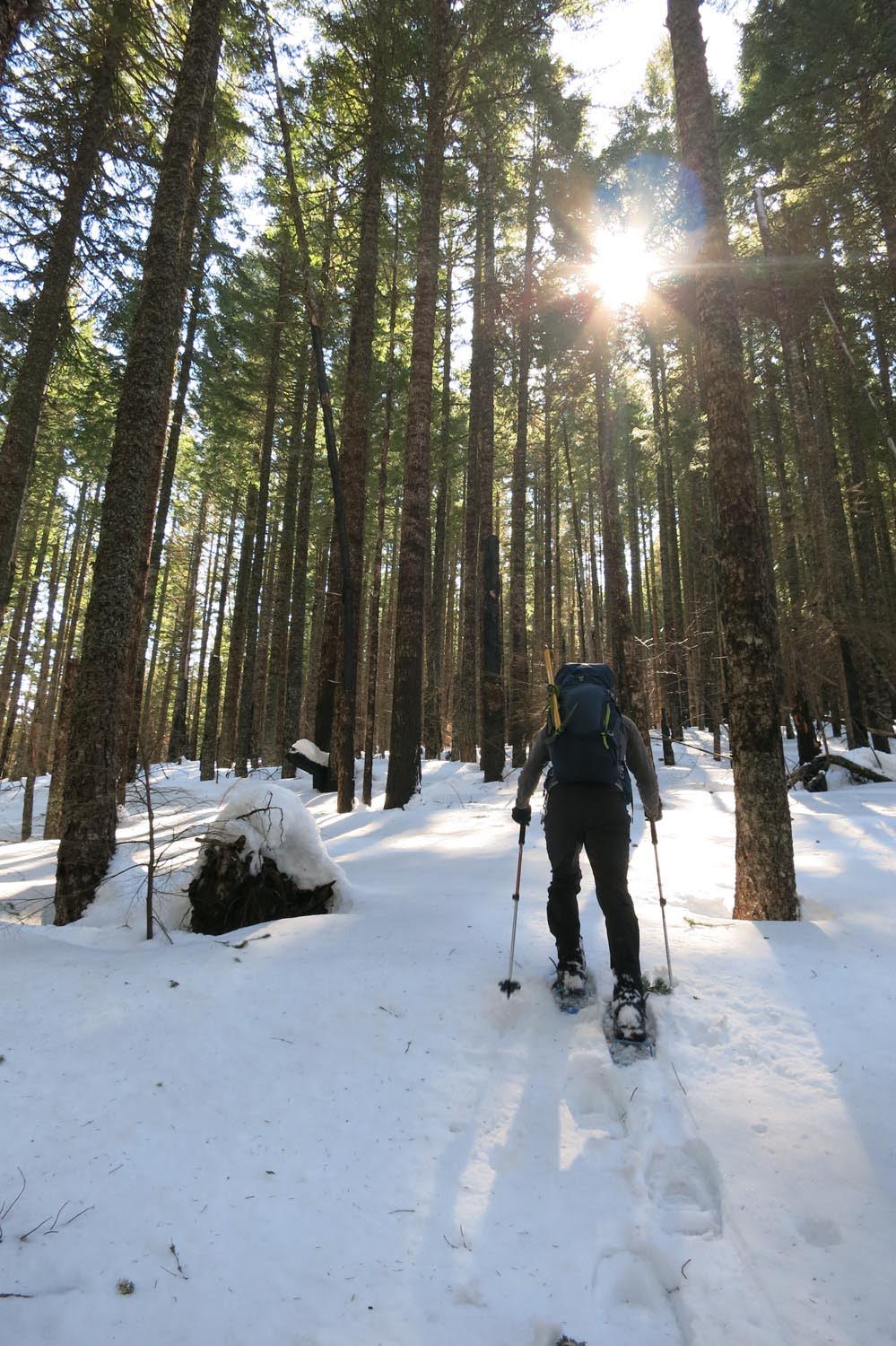
The snow was pretty crappy lower down (compacted and frozen in the powerline corridor at the bottom, slushy above that) but gradually improved as we broke trail above the Breather flats.
In the high burn that starts at around 3400 ft, the snow started to get colored by charcoal blowing off the trees.

Almost Neapolitan snow - we just need some strawberry.

The high burn area also casts neat shadows on the snow.


We came to the higher burn zone sign a little above 4000 ft - I think usually this sign is at shoulder height.

The snow conditions improved dramatically as we approached the edge of the Lindsey Gap. There is a lot of snow up here! It formed all kinds of interesting features, like cornices and waves and folds.


Breaking treeline at the bottom of the first talus field, huge drifts. The snow became nice and styrofoamy.


Looking up the first talus field towards the summit. Aim for the upper left corner to go through a couple of trees and pop out into the second talus field that leads up to the road.

A nice old tree.


Second (smaller) talus field.

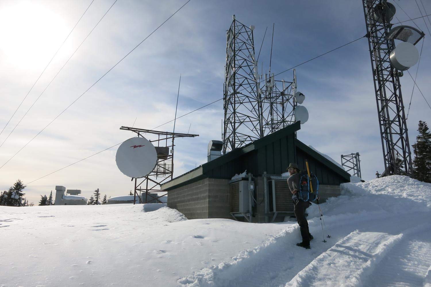
It looked like some sort of sno-cat had driven up the road in the past day or two to service the towers. We were happy to have a groomed trail and rejoiced in the ability to walk without snowshoes!

Well, the snow is definitely above the fence.
I imagine these little bunkers were totally buried just a week ago.

The tallest tower is totally rime blasted. Chunks kept falling off while we were up there.

Normally you have to climb the ladder to get on top of this building....


Due to our DN start and the endless trailbreaking, it was now about 4:30pm. Hooray for Daylight Savings! But we scrapped loop plans and opted to go down the way we came up.


6.5 hours up but only 2.5 hours down. We made it back to the car without headlamps.
Ben and I got a DN-style alpine start from the Starvation TH at approx 10am, because "someone" (hint: it wasn't me) forgot their boots and we had to drive back to Portland from Cascade Locks before driving back to the TH...
I was last here on 3/2/19, so basically two weeks ago, and the conditions are very different. I believe the weather decided it was officially "spring" when the clocks changed last week. All the lower elevation snow is going to be gone in a few days.
Dog appears to have already melted out below Puppy Dog.
Lancaster is no longer frozen.
For reference, this was 2 weeks ago at Lancaster:
It was hard to tell if people went up last weekend due to the consolidation and melt of the snow. We really only saw one set of prints heading up; this "bench" I think is actually the result of newer snow melting out around the more solidified track from a month ago.
The track continued around onto the switchbacks past the 1300 ft road junction, but we opted to go up the Direttissima.
Same spot 2 weeks ago:
About the spot where Shop and I turned around last time. It was covered with unconsolidated powder and all the trees were covered in hoarfrost. Ch-Ch-Ch-Changes...
The other tracks joined the Direttissima but stopped at around the 1600-1700 ft mark. After this, it appeared no one had been up the Defiance side since I last tried on 2/18/19. That day the trail was broken to about 2300 ft and I broke from there to 3800 ft before turning around. Not sure when the last time someone actually made it to the summit was. I would consider it possible but unlikely that someone could have summited via Starvation if no one had summited via the Defiance side during the same period.
The snow was pretty crappy lower down (compacted and frozen in the powerline corridor at the bottom, slushy above that) but gradually improved as we broke trail above the Breather flats.
In the high burn that starts at around 3400 ft, the snow started to get colored by charcoal blowing off the trees.
Almost Neapolitan snow - we just need some strawberry.
The high burn area also casts neat shadows on the snow.
We came to the higher burn zone sign a little above 4000 ft - I think usually this sign is at shoulder height.
The snow conditions improved dramatically as we approached the edge of the Lindsey Gap. There is a lot of snow up here! It formed all kinds of interesting features, like cornices and waves and folds.
Breaking treeline at the bottom of the first talus field, huge drifts. The snow became nice and styrofoamy.
Looking up the first talus field towards the summit. Aim for the upper left corner to go through a couple of trees and pop out into the second talus field that leads up to the road.
A nice old tree.
Second (smaller) talus field.
It looked like some sort of sno-cat had driven up the road in the past day or two to service the towers. We were happy to have a groomed trail and rejoiced in the ability to walk without snowshoes!
Well, the snow is definitely above the fence.
I imagine these little bunkers were totally buried just a week ago.
The tallest tower is totally rime blasted. Chunks kept falling off while we were up there.
Normally you have to climb the ladder to get on top of this building....
Due to our DN start and the endless trailbreaking, it was now about 4:30pm. Hooray for Daylight Savings! But we scrapped loop plans and opted to go down the way we came up.
6.5 hours up but only 2.5 hours down. We made it back to the car without headlamps.