Cirque of the Towers Loop

This forum is used to share your experiences out on the trails.
User avatar
K.Wagner
Posts: 652
Joined: June 2nd, 2013, 1:25 pm
Location: Vancouver, WA

Cirque of the Towers Loop

Post by K.Wagner » August 26th, 2018, 6:25 pm

Subtitle: An test of advancing age VS altitude

The Cirque of the Towers is not a name that is a well known destination, here on Oregon Hikers. The simple reason is that it is in Wyoming, about a day & half drive from Portland. To any serious rock climber, it is a well known mecca of clean granite climbing, with faces soaring thousands of feet into the blue skies.
104-Cirque Panno-S.jpg
Here is the basic map of our route. We traveled clockwise. The gold section of the route is user trail, the rest is all official forest service trail. See comments following!
Cirque of the Towers loop.jpg
There is one little hitch for those of us here in the beautiful PNW, living someplace close to sea level ….. this is high elevation country. Most of the summits in the above picture are over 12,000 feet. Our trail head was at 9,081 feet. We climbed over 2 passes, one at 11,447 feet, the other at 10,790 feet. We did spend the first 1/2 day in the area doing an easy hike, and then spent the night at about 8,000 feet, so that our bodies had some chance of acclimating, but that wasn't nearly enough to feel strong going over the passes. So, onto the report.

Every year, my brother Jim & I come up with a back pack trip to someplace new. We had been through most of the Oregon Cascades, some of the Olympics, and most of the Washington South Cascades. Years ago, he had gone to Grad School in Fort Collins, CO. During that time, he did do a climb in the southern end of the Wind River Range, called “The Cirque of the Towers”, and we thought it would be fun to visit that area again. Looking at the maps and climbing descriptions, we had fantasies that we could easily scramble up to a couple of the class 3 summits that are right next to the passes we would be going over.

So, he got an early start from Corvallis and drove up to my house in Vancouver. We piled everything in my car, and were on the road by about 8:00. 12 hrs & 750 smoky miles later we pulled into the campground on the Snake River, just shy of the Wyoming boarder, where we slept really well, with the water sounds just feet away from our heads. The next day we drove the 120 miles to Pinedale, Wyoming, which reminded us both of Sisters. It sits at about 7,120 feet, which was high enough that after sitting for so long, just getting out of the car and walking into the grocery store made our heads feel a bit odd. We tried to do an easy, higher elevation hike that afternoon, which did reward us with views down the glacially carved Fremont Lake, but it was really hot, so we turned around at about the halfway point, and found a nice place to camp that evening.

That morning we got a good start, and drove the remaining 50 miles to the Big Sandy Lake Trail Head, at 9,080 feet. It was good road all the way, even the last few miles that we had read warnings about being pretty rough. When we came around the final bend to the parking area, there were more cars and horse trailers than we had ever seen at a trail head! It reminded us of a Fred Meyer parking lot!
208-Big Sandy TH cars-S.jpg
There were about 1/3 again as many vehicles behind me.

As we were doing the final packing, we talked to a few people, and they reassured us that it was a huge area, and we wouldn't feel crowded, but not to expect solitude either. So, off we went, up the trail. The first 1/2 mile is a smooth highway, with almost no climb.
010-Big Sandy Lake Trail-S.jpg
Then we turned north on a more typical trail and started earning Brownie Points for hiking part of the Continental Divide Trail. We immediately felt the elevation as the trail climbed. We passed by Meek's Lake (did ya'll recall that our Joseph Meek was a mountain man for 11 years before he was a settler & a politician?) The trail had turned really gentle, which we did appreciate. It passed through many huge meadows and by small lakes with views of granite summits to the north and east.
016-Pack train in Fish Creek Meadows-S.jpg
The heat was really starting to wear on us, so we were relieved when we finally started to drop to Dad's Lake, which was to be our first camp.
019-Dad's Lake Pyramid Peak-S.jpg

After dinner, we found a big crevice in the rocks to stash the bear canister, and a good tree to hang the other food bags from. That evening we were rewarded with a beautiful sunset and reflections off the lake. Jim had seen rain off to the west, so we reluctantly put the rain fly on. In the middle of the night we felt pretty smug when the rain drops started to make that familiar sound on the fly. It came down pretty hard, but it didn't last too long.

The next morning was clear & delightfully cool. The still water gave some really nice reflections of the hills ahead. Our route would take us through the notch, then around the bare granite mound, where we would turn eastward.
030-Dad's Lake, 10994, Easy Day Peak-S.jpg
First we would pass by Marm's Lake.
037-Marm's Lake-S.jpg
Here a very friendly couple offered to take our picture.
045-At Marm's Lake-S.jpg
From there it was a bit of rough trail up to a broad pass in the notch to the right of the mound in the previous picture. The last bit was pretty steep, and we really felt it. We stopped for lunch on some boulders, and 5 young women came by, being very loud, and playing an occasional reggae tune from an i-pod. Then it was almost flat as the view into the Wakashie Creek valley opened up.
055-Washakie Creek-S.jpg
The trail stayed fairly close to the creek for quite a ways, then crossed it.
058-Washakie Xing, Bair Peak-S.jpg
That's Bair Peak in the background.

From there, it was a gentle, but seemingly long climb to Shadow Lake, which for some reason, I did not take a single picture of. We think that it got its name from the long shadow that falls across the length of the lake in the evening. The 5 young ladies were making quite a commotion in the lake, playing music and splashing around in the water. There were several young men who didn't seem to mind a bit! They ended up making camp just below us, and partied late into the night. How late? I don't know, I fell asleep pretty quickly.

From shadow lake, the route is a user trail. Most of the way it is very easy to follow, but in places it crosses big granite slabs. Thankfully there were cairns in place to keep us on track.
063-Trail cairns-S.jpg
The mountains around us were really starting to get jagged and impressive.
061-Wolf's Head, Overhanging Tower-S.jpg
The next lake we came to was Billy's Lake. At this point, we were at about 10,600 feet elevation, and almost getting used to it.
065-Billy's Lake, August 16th Peak-S.jpg
The sharp summit across the lake is August 16th Peak. We would get close to it, then start climbing up to Texas Pass, our goal for the day.

First we would go around Barren Lake, then around Texas Lake. This is where we got our first real view of the route. We watched three other groups work their way up the slope, and it didn't look like they were having any problems, so we would just grind it out.
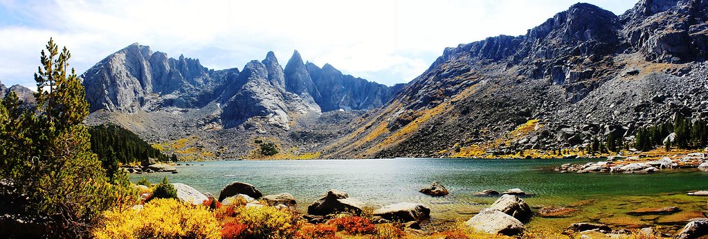
074-Texas Lake, Texas Pass-S.jpg
Last edited by K.Wagner on August 26th, 2018, 7:21 pm, edited 4 times in total.
Kelly
There is no shortcut to anyplace worth going to.

PM me about the soon to be released:
Skamania 231
"How to really get off the beaten path in Skamania County"

User avatar
K.Wagner
Posts: 652
Joined: June 2nd, 2013, 1:25 pm
Location: Vancouver, WA

Re: Cirque of the Towers Loop

Post by K.Wagner » August 26th, 2018, 6:39 pm

Chapter II

It's not until you are standing at the base of the slope, looking up, that your brain sort of comprehends what is ahead. At this point, we were at about 10,800 feet, looking at a 700 ft climb in about 1/3 mile.
083-Starting up Texas Pass-S.jpg
This gives a perspective of the grade
088-Boots-S.jpg
Here, looking down from about 2/3 of the way up.
089-Looking down at 11,250 ft-S.jpg
1 1/2 hrs later, we hauled our sorry rears over Texas Pass (11,447 feet), where a group going the other direction felt sorry for us and volunteered to take a picture.
093-at Texas Pass, 11,447 ft-S.jpg
Not long after we got on top, a 12 year old girl came bouncing up, with a 30 lb pack. She had done it in about 40 minutes! She dropped her pack and went skipping over the boulders, waiting for the rest of her family to show up. She does give some scale to the scenery.
097-Looking N, 12yo girl, August 16th Peak-S.jpg
We had just crossed the Continental Divide, and were now looking over the Mississippi side! What a view!
099-Looking S, into cirque-S.jpg
From here, it was going to be a lot of rough down hill, but for now, the focus was simply to get down off the pass, which entailed more open granite slabs and green meadows. We were both struck by the vegetation differences between the two sides. The north side felt very barren, with just an occasional clump of Penstemons. The south side was lush green meadows, water flowing everywhere & full of flowers. To that point we had only seen a couple of Indian Paintbrushes, but here, they were common.
108-high meadows-S.jpg
We didn't get as far down as we had planned before the energy ran out. Oh well …. such is life. We found a nice little flat spot with water close by with an amazing view and settled in.
119-Camp-S.jpg
We awoke the next morning, with Pingora Peak beautifully filling our view.
121-Morning on Pingora Peak-S.jpg
Soon I was hearing distant voices & familiar climbing calls: “On Belay”,“Up Rope!”, “Climbing!”, etc. It took a little searching, but soon I found the moving dots over on Pingora Peak. It turned out there were three different groups working on the 1500 foot face.
122-Climbers-S.jpg
The guy in the middle is free traversing the granite slab. Several of the climbers had some problems on this traverse, trying to find footing that they were confident in. We could see them try one placement, then retreat, then try another, then retreat, then try higher, then lower, before they finally sucked it up and trusted friction. A slip there would have been really ugly!

After watching them for at least an hour, we decided it was time for us to suck it up ourselves and finish packing so that we could make a least a few miles today. We still had to descend about 700 feet down to Lonesome Lake, then climb 630 feet up to Jackass Pass, and optimistically drop 1,100 feet down to Big Sandy Lake.

The drop down to Lonesome Lake was steep, but uneventful. We had some problem finding the correct trail on the south side of Lonesome Lake, and did some tiring, but I thought very interesting, cross country to find the old trail, which shortly was crossed by the new, well worn trail. So then, it was time to settle in for a moderately steep, but mostly clean trail up. Here is a view from low down the trail of War Bonnet & Pylon Peak. Scenery like this certainly helped to keep our minds from getting completely bogged down in the effort.
137-War Bonnet & Pylon across Lonesome Lake-S.jpg
Up & up we climbed. This pass wasn't nearly as steep as Texas Pass, and there was a real trail, but it was still work! With constant wild flowers we found frequent reasons to stop and enjoy (and rest!).
140-Wildflower distractions-S.jpg
Finally the grade began to ease, and we could actually see the summit.
143-Nearing Jackass Pass-S.jpg
We had to look back north and marvel at the country we had been walking through. Texas Pass, that we had gone over the day before is the notch in the center with the snow field. From here on, we would be back on familiar ground, as we had crossed the Continental Divide again, and were on Pacific Ground!
145-Texas Pass from Jackass Pass-S.jpg
Then it was time to start down again. Soon we were looking at Arrowhead Lake, where we were to make a poor decision, that would cost us a lot of time and energy, but in the end, maybe was the best.
151-Arrowhead Lake-S.jpg
Last edited by K.Wagner on August 26th, 2018, 7:01 pm, edited 1 time in total.
Kelly
There is no shortcut to anyplace worth going to.

PM me about the soon to be released:
Skamania 231
"How to really get off the beaten path in Skamania County"

User avatar
K.Wagner
Posts: 652
Joined: June 2nd, 2013, 1:25 pm
Location: Vancouver, WA

Re: Cirque of the Towers Loop

Post by K.Wagner » August 26th, 2018, 6:46 pm

Chapter III

There are 2 routes around Arrowhead Lake. The route to the left climbs quite a bit, to get over the cliffs that come down to the water. The route to the right, that doesn't climb much, passes over the boulder field, visible in the picture. How bad could a boulder field be? Surely with as well worn as the trail was, climbers would have certainly moved rocks and made cairns to mark the way.... It wasn't until we were up close & personal with some of these boulders that it finally penetrated our skulls that these were no ordinary “boulders”! The big ones were as big as a small house, and the small ones were as big as a Fiat! It would take us about an hour to cross the 100 yards of rock.
152-Boulder Field-S.jpg
Finally there was some trail, then there were more “normal” boulders to deal with, then some trail, then more boulders to cross the outlet stream. By then, we was cooked! Here is Jim dealing with the last boulders, crossing the outlet stream.
155-Jim crossing North Creek-S.jpg
There was some grass among the rocks, and hints of flat spots. I poked around, trying to find a spot that was semi-level and didn't have big buried rocks. This was the best I could come up with and the foot of the tent was only about a foot lower than the head.
162-Camp, Arrowhead Lake, Wolf's Head, Pingora-S.jpg
Looking across the valley, all we could see was this rock face, called “The Plume”.
163-The Plume, across valley from camp-S.jpg
All around us were clumps of White Columbine flowers. Such a pleasant little spot.
179-White Columbines-S.jpg
To the south, with a little climbing, the view was immense. We could see the steep drop down to North Lake and almost see Big Sandy Lake.

We slept good that night, until ….. we both were startled awake by water sprinkles on our faces. We jumped up because we both knew instantly that one of the infamous Rocky Mountain squalls was about to blow over. I grabbed the fly, and the wind immediately started it flapping. Fortunately we had staked the tent down good, so it wasn't too hard to get the fly secured. We couldn't get the 2 additional stakes in at the foot of the tent, so more paracord was sacrificed to go around nearby rocks. Then we climbed back in, and it stopped. We were pretty sure that it would follow the pattern of the earlier storm, and it did. After perhaps 1/2 hr, the wind really got serious and the rain came down and the tent flapped. We went to sleep.

The next day was supposed to be easy trail. The first 1 1/2 miles was steep, but nice trail, as we dropped down to North Lake and around the upper end. Then we climbed a bit, and started dealing with bare slabs of granite. We could still see the gouging from the glacial ice all over the bare faces.
188-Granite trail-S.jpg
Then it was broken granite
192-Only a climber could call this a trail!-S.jpg
We started cracking jokes about: “this route could only be called a trail by someone with a warped sense of humor!” It seemed to go on forever....up & down over ridges, hints of trail here & there. Admittedly, there were some really pretty sections that did take the tedium off. Here, we are almost through the rough stuff.
196-Easier trail-S.jpg
From here, it was a drop down to the crossing of North Creek, which seemed to be a real watering hole for climbers heading up to the cirque. Oh, to be young again, and think that it might be fun to carry a 55lb pack up that trail!

After the creek crossing, the trail almost seemed like a paved bike path. It was such a relief to just walk and not have to pick every footstep.
197-After Xing North Creek, easy trail-S.jpg
We passed quite a few people heading up the trail. We passed several families, and several small groups of climbers, all with humongous packs that had ropes draped over the top. Finally we dropped down to the meadows of Big Sandy Lake.
200-Big Sandy Lake, Dog Tooth Mtn-S.jpg
From this point, it was big trail for 4 1/2 miles, with only about 600 feet of descent. For about 1/2 of the distance, the beautiful Big Sandy River was close to the trail. It reminded us both of the Metolius River.
204-Big Sandy River-S.jpg
When we had finished, we were both glad to be done, but also so sad that it was over.

Final numbers:
Total Days ---- 8
Hiking Days ---- 5
Distance ---- About 24 miles
Elevation Gain ---- About 5,100 feet
Number of pictures ---- 220
Miles Driven ---- 1925
Memories ---- Immeasurable
Last edited by K.Wagner on August 26th, 2018, 7:15 pm, edited 3 times in total.
Kelly
There is no shortcut to anyplace worth going to.

PM me about the soon to be released:
Skamania 231
"How to really get off the beaten path in Skamania County"

User avatar
texasbb
Posts: 1175
Joined: July 26th, 2008, 8:16 pm
Location: Tri-Cities, WA

Re: Cirque of the Towers Loop

Post by texasbb » August 26th, 2018, 7:11 pm

Big thumbs up! I did my first Winds trip (a little north of your route) last year, and have almost decided to move up my retirement date so I can fit in more trips before I die! I too felt the elevation. It had been about 30 years since I hiked at those elevations. I drove from home to Pinedale in one day, then was on the trail at 8:00 the next morning. It took until the third day before the lethargy subsided.

Amazing place. Thanks for the report! Sounds like the two of you had a grand time.

User avatar
BurnsideBob
Posts: 539
Joined: May 6th, 2014, 3:15 pm
Location: Mount Angel, Oregon

Re: Cirque of the Towers Loop

Post by BurnsideBob » August 26th, 2018, 7:49 pm

What a wonderful trip! Too bad the Winds are so far away, as they are amazing!

Your trip brought back memories of a similar trip my wife and I did mid Sept 2012. Even that late the Big Sandy trail head parking lot was full, just not overflowing, and we met quite a few people every day, whether on trail or not. That was 2012, a terribly hot year, and while temperatures had moderated by Sept everything was yellow and brown and the fish were down deep--caught nothing.

And we suckered into that same boulder patch--make it down to the north end of Arrowhead Lake--climb back up 300 feet or go for the boulders? Boulders it was. While we were floundering along next to the water a couple climber dudes, following some marked route higher up, breezed right by us in minutes. Local knowledge rules.

It's an inspirational place and thanks for sharing your experience. Here's three photos from our trip to further pique everyone's interest:

Image Shadow Lake

Image 
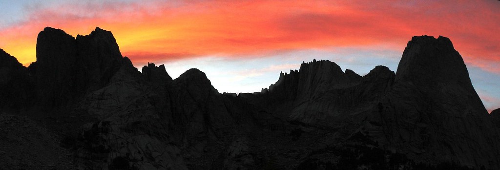
Alpenglow on the Cirque of Towers

Image 
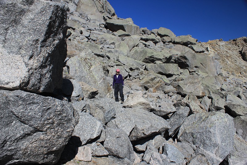
Arrowhead Lake Boulder Field
I keep making protein shakes but they always turn out like margaritas.

User avatar
Water
Posts: 1356
Joined: May 28th, 2008, 10:03 pm

Re: Cirque of the Towers Loop

Post by Water » August 26th, 2018, 8:46 pm

great write-up. thank you for sharing!

the whole area is absolutely fantastic. My wife and I did the WRHR (wind river high route) mix of on and off trail from the north to the south in 2015, and it was by far a culmination trek of our outdoors experiences, drawing on a lot of climbing, off trail, mountaineering, and nimble backpacking experiences in order to be successful.

We did one final big day from mays lake (north of skull lake) to big sandy.. and also had a little trouble finding the trail up to texas pass....and then almost let ourselves deviate down to the right where it looked like obvious trail around the lake, instead of opting left which seemed counter-intuitive. Actually the section from texas pass until it was actual flat trail 6 miles back to big sandy was pretty brutal for being a 'trail'.

anyways, can't wait to one day go back.
Feel Free to Feel Free

Webfoot
Posts: 1765
Joined: November 25th, 2015, 11:06 am
Location: Troutdale

Re: Cirque of the Towers Loop

Post by Webfoot » August 26th, 2018, 11:07 pm

That dude in the orange shirt has forearms that belong on one of those granite faces.

User avatar
Chip Down
Posts: 3043
Joined: November 8th, 2014, 8:41 pm

Re: Cirque of the Towers Loop

Post by Chip Down » August 27th, 2018, 6:38 pm

Surprisingly, I've never given much thought to elevation as a source of fatigue. I get exhausted at 4000' and 8000' and 12000'. It's hard for me to discern the difference, even though objectively I know there is a difference. Perhaps the salient difference is the way I can become winded doing ordinary tasks...breaking down a tent and stuffing it into my pack might have me breathing hard at 10000'. I think it would be fun to drive to Pikes Peak (or similar) and see how I feel running around...but not fun enough to justify the drive.

Now that I think about it, I used to experience a lot of gurgling noises in my throat/chest in the 8k-14k range, possibly a benign precursor to high-altitude pulmonary edema. Typically followed by a cough the following day or two. But these things are easier to pin down than general fatigue.

Oh, and I did notice my resting pulse was elevated when I was at the top of Shasta.

But ultimately, when the 14 year old girl runs past you, elevation is no longer a viable excuse :lol:

User avatar
romann
Posts: 2417
Joined: May 28th, 2008, 10:03 pm
Location: Vancouver, WA

Re: Cirque of the Towers Loop

Post by romann » August 28th, 2018, 11:49 pm

Great report Kelly, it's grand country indeed. Thanks for writing it up, all the route detail and the map. I kept researching about Wind Rivers for a while, bought a big map, but then decided it's better left for retirement (need a nice goal anyway :) ). Wow didn't know there would be crowds on trails in Wyoming. But that country is so open (especially west side lakes, before you got to steep part), it just begs exploration, no trails needed.

wnshall
Posts: 188
Joined: July 17th, 2009, 10:31 am

Re: Cirque of the Towers Loop

Post by wnshall » August 30th, 2018, 9:51 am

Wow! This is so cool. Thanks for posting. I hope to someday get out to that area, but in the meantime your pictures and words help to inspire.

Post Reply