Day 1
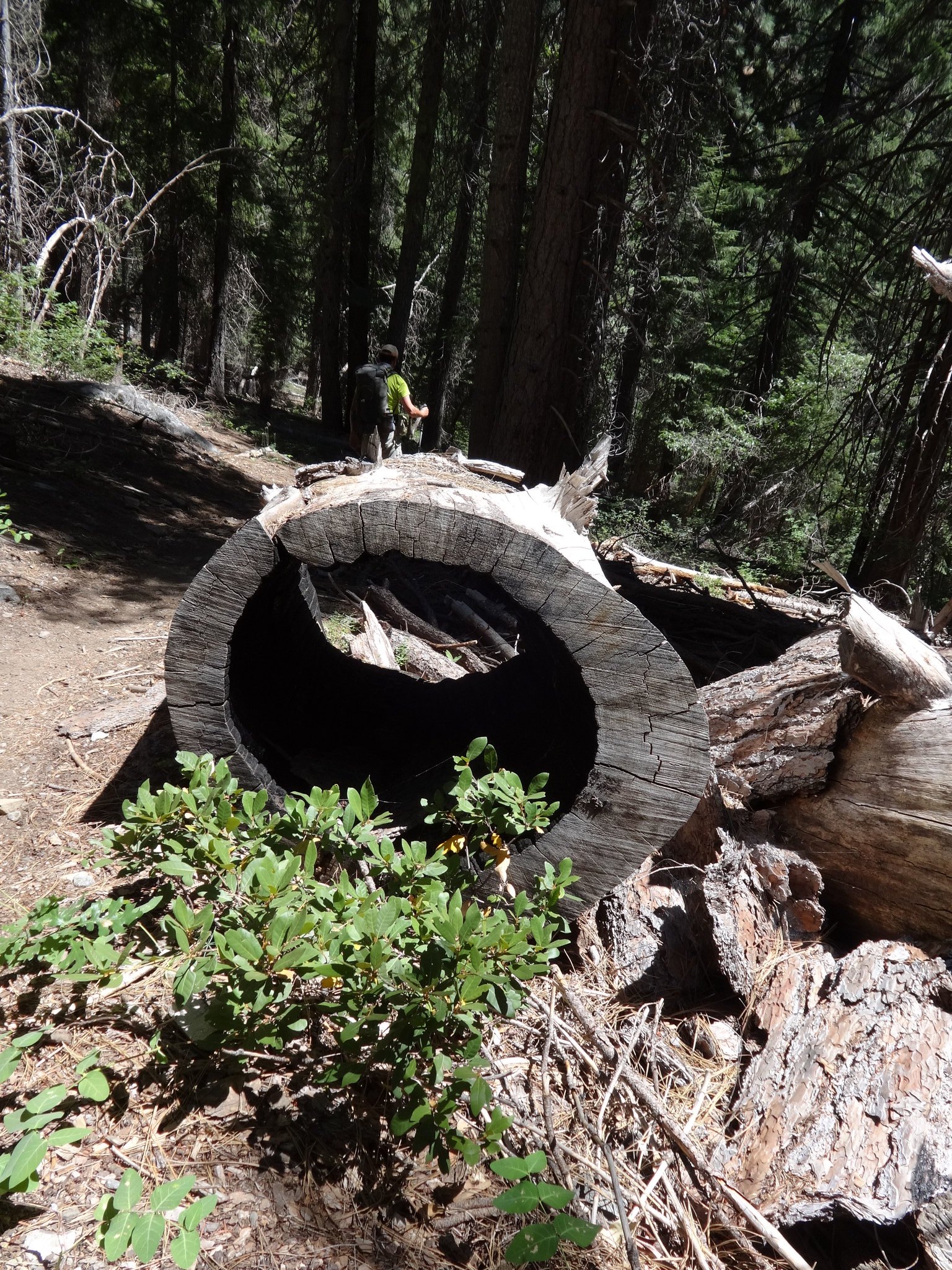
Born2BBrad picked me up at my home, then we drove to Yreka, California, had breakfast (an unusual indulgence), and then continued on to the China Spring Trailhead {China Spring on one map, China Gulch on another map and at the trailhead?} at the end of Forest Road 37N07. We didn't depart the trailhead until 11:00AM and by then it was becoming evident that we were in for a HOT day on the trail. From the trailhead, we contoured south on the China Spring Trail (USFS #11W08) across China Creek through the remains of the 2006 Caribou Complex fire,
 The China Spring Trail climbs through the remains of a forest
and then did a steep ascent [which used to be even steeper when the China Spring Trail started up the ridge from a lower, now abandoned, trailhead] some 1,200 feet to the top of the Salmon River divide and the former site of Hunters Camp. From here we got our first look at snowy Thompson Peak in the distance.
 Salmon Creek divide with snowy Thompson Peak in the distance
After a cooling break at the saddle, we continued on the 11W08 as it did an abrupt 1,200-foot descent, through the remains the 2006 Bar Complex fire which burned on this southern side of the divide, to its junction with the North Fork Trail (USFS #12W01) above Grizzly Creek.
 Descending the China Spring Trail toward Grizzly Creek
Here, we turned south and ascended the #12W01 toward Grizzly Meadow. By now the heat had turned oppressive and our water was running low. It was torture to hear delightful Grizzly Creek gushing along just out of reach owing to either brush or gullies.
 One of the many small waterfalls along Grizzly Creek
It was a mercy to finally reach our planned camping spot at tree-shrouded Grizzly Meadow. Except for a few downed trees, the trails from the trailhead to here were in good condition and easy to follow.
 Grizzly Meadow with Thompson Peak on the horizon
Despite the popularity of this hike, there aren't that many good campsites in this area and the only two people ahead of us on the trail this day took one of the larger sites near the creek. Fortunately, they were able to direct us to an equally nice site back in the trees. Which was good, because about three hours after we made camp, a party of six showed up hoping to camp on this spot - we directed them to another spot a little further up the trail.
 Our campsite at Grizzly Meadow
The heat had taken its toll on us to the extent that we decided to modify our plans, as doing the original loop would mean descending to the infernally hot regions below 4,000 feet. Instead, we decided to go higher and climb Thompson Peak, where things might be a little cooler. But reaching the peak would first require us to reach Grizzly Lake via what the Forest Service calls the "Grizzly Scramble" - an obvious, but very steep, use trail up the side of the canyon to the left of 600-foot Grizzly Falls.
 The Scramble goes up through the greenery and around to the left
So, with a new plan in place, and the Scramble deferred until the morning, we gratefully called it a day.
Day 2
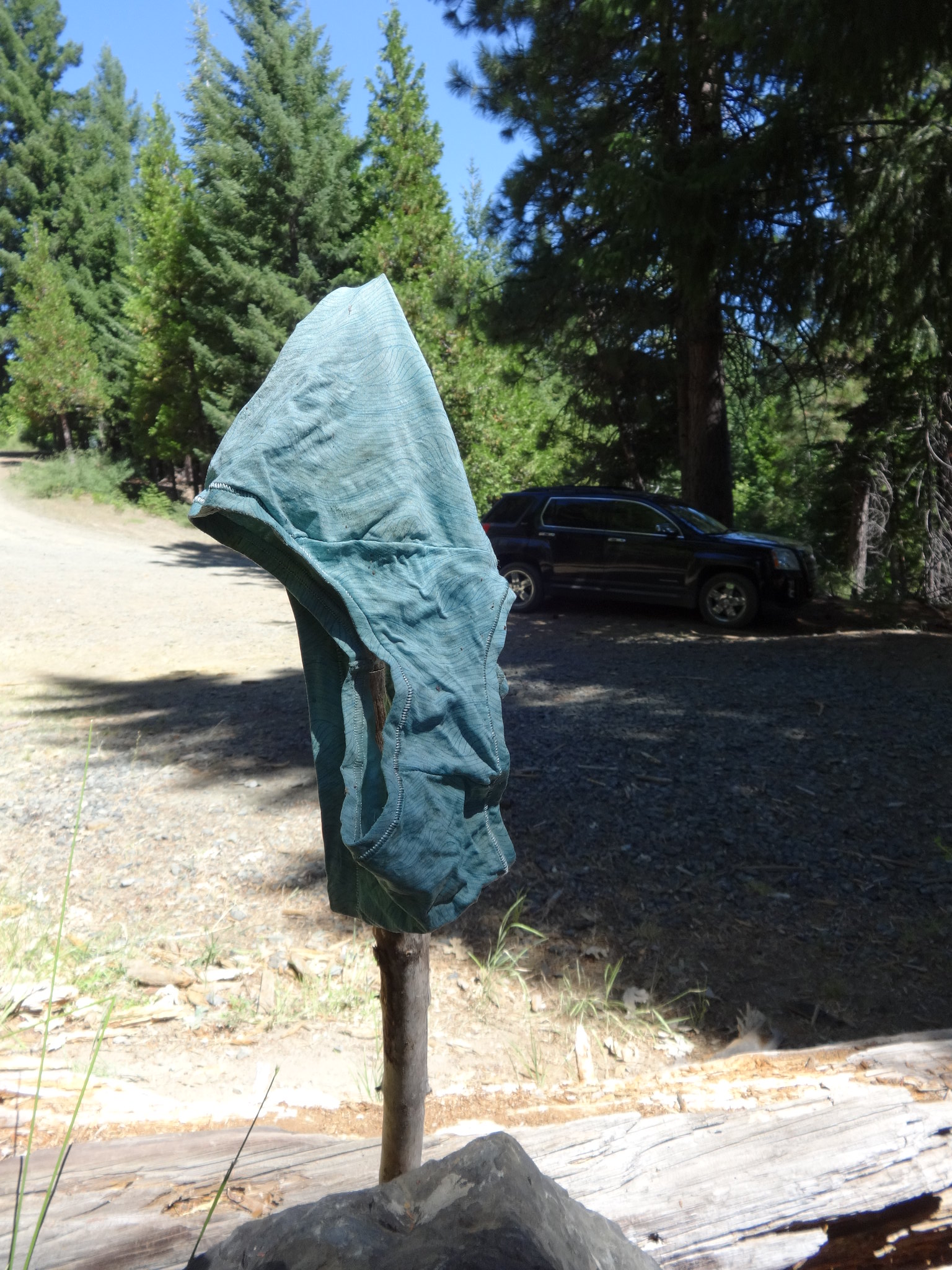
This day began earlier than expected when our camp was raided - not by bears - but by salt-crazed deer! They stole (and presumably chewed) Brad's underwear and bandana, gnawed the straps on his poles, and generally scattered the contents of his pack around our camp. I had all my gear in my tent which - despite noses poking at the fabric - allowed me to avoid Bambi-inflicted damage. These deer were not afraid of us - trying to run them off only made them circle around and attack from another direction!
 When Bambi goes bad...
After securing our stuff from further depredation by deer and rodents, we tackled our first challenge of the day - getting back across the creek at dawn.
 Crossing Grizzly Creek at first light
Immediately after that, we entered the boulder field at the head of the valley and then swung left and up on the use trail that is the Grizzly Scramble (and not a breakfast item at one of the Black Bear restaurants). It's truly a scramble (hands and feet needed) and it's steep - gaining about 1,000 feet in less than 0.5 miles. It also gets a little harder to find as the slope eases just before you reach Grizzly Lake.
 Scrambling up the Grizzly Scramble
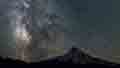
Once we got to the lake, it was immediately apparent why it's considered one of the most spectacular lakes in the Trinity Alps (if not elsewhere as well). It fills the vast cirque beneath Thompson Peak, the highest peak in the Trinity Alps and the second highest in the entire Klamath Mountains. The Thompson Glacier (permanent snow field on the USGS maps) extends from the base of Thompson east toward Julius Caesar Peak and sends numerous large cascades tumbling down the granite cliffs.
 Thompson Peak over Grizzly Lake early in the morning
Just on the other side of the lake's outlet, there are two jutting granite platforms that gave us a great side view of Grizzly Falls.
 Grizzly Falls from the rim
We sat for awhile enjoying the lake and scoping a route up Thompson's flank to the low point on the ridge from where we could traverse southeast to the summit.
 The low point (arrow) on the ridge northwest of Thompson Peak
A handy use trail didn't present itself, so we went west on granite slabs up the ridge just north of the lake and, at about 7,900 feet, turned south on to a broad bench that aimed us right at the low point.
 On the bench at around 8,000 feet
We got about halfway to the low point before we had to start traversing up on snow - perfect spring snow on a moderate slope, great for steps with no slippage!
 On snow after leaving the bench at around 8,200 feet
Once we reached the low point on the ridge, we had an excellent view of Grizzly Lake and a smoke-obscured view of Mount Shasta,
 The view of Grizzly Lake from the low point
as well as one of the ridge we had to traverse to reach the summit.
 Thompson Peak (right) and Caesar Peak (with snow) from the low point
It was here that things got a little dodgy. A lot of the beta we'd accumulated for this route was either too sketchy to be useful or (worse) wrong. We had been told that there was a use trail from the low point to the final summit blocks and there was, but it faded away about halfway to the summit. After that our instinct was to stay high on the ridge despite having to repeatly climb over or around an increasingly convoluted jumble of boulders. There are obviously many different routes here, but none are straightforward and none lend themselves to easy description. About 200 feet below the summit, Born2BBrad said he'd had enough of this thrashing and he'd wait for me if I wanted to go for it. Lacking his common sense, I pressed on. Nearer the summit it got steeper and I found myself making Class 3 moves out over the abyss. After two false summit boulders, I could finally see the next one was higher and (hopefully) the last one on the ridge. But it was across a gully, so I had downclimb about 30 feet and then back up to a nice scramble to get on top of the highest rock.
 Peering down the gully just before the summit
I had promised a quick go at this, so I got a shot of the nearest witness mark (there are at least five benchmarks and witness marks up here),
 One of the USGS witness marks on the summit
one poorly aimed shot of the Wedding Cake to the south,
 The Wedding Cake from the summit
and then retraced my route to rejoin with Born2BBrad. Yes, I got to the summit but not in the best style - it would have been better if we both could have gotten there and had some time to loll around and enjoy the view. Staying lower on the ridge made our return to the low point go a lot faster and easier [Based on this experience and further research, it would have been better to have traversed 0.5 miles on the western side of the summit ridge, climbing only slightly and staying well below the craggy apex, until directly below the summit, then ascend a gully to the top.].
 Grizzly Lake and Mount Shasta from the low point on the ridge
Now in full sunlight, Grizzly Lake was even more amazing as we passed it on our return.
 Grizzly Lake, with cascades from the melting snow fields
 Grizzly Lake and Thompson Peak
Getting back required crossing the outlet of the lake on logs held together with tent cord and perched just 20 feet or so from the edge of 600-foot Grizzly Falls.
 Born2BBrad crosses the logs over the outlet of Grizzly Lake
It had been cool and pleasant up on the peak (as we'd hoped) but was much warmer down in camp. So we turned in early in anticipation of a cool, oh-dark-thirty start in the morning. Two people camped near us that night and by then all the good sites in the meadow were taken.
Day 3
Once again, the day began early with a deer attack - not on us, our stuff was all secured by now - but on the camp next to ours. Our headlamps revealed a three-point buck contentedly chewing on what looked like someone's shirt. Trying to scare the buck away didn't work too well - he just dropped the shirt and started in on a pair of shorts! When we passed their camp on the way out, we could see our neighbor's (chewed) clothes strewn about and their packs all spilled open. We tried to wake them but there was no response, so we ran to save ourselves.
 Across Grizzly Creek with the deer close behind...
After that, it was just back the way we'd come, with a look back at Thompson,
 Morning light on Thompson from the North Fork Trinity Trail
another covetous glance at the waterfalls we'd wished we'd been able to easily access on the way in,
 Another waterfall along Grizzly Creek
then up 1,200-feet and over the Salmon divide - surprisingly easy in the cool of the morning - and back to the trailhead. All told, about 19 miles roundtrip from trailhead to summit, with about 7,000 feet of elevation gain. Going out, we passed 16 backpackers (one group of 10!) and two dayhikers heading in and there were a dozen or so cars at the trailhead. Having been awed by Grizzly Lake, we can well understand why so many folks are willing to work hard to see it. We just weren't sure where all those people were going to find campsites? Oh, and did we mention the deer...
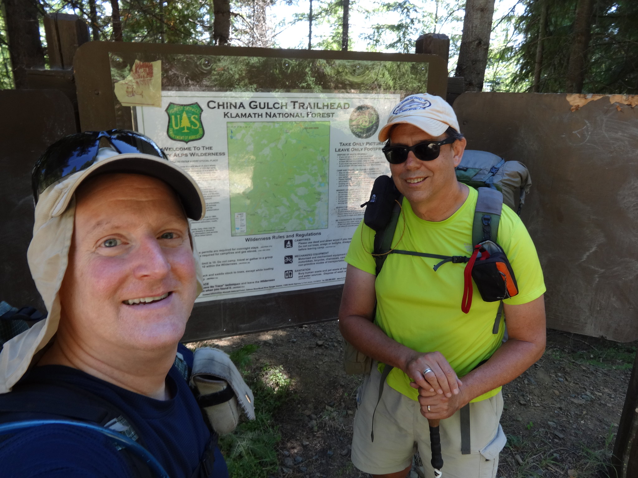
 Hot, sweaty, but back at the trailhead
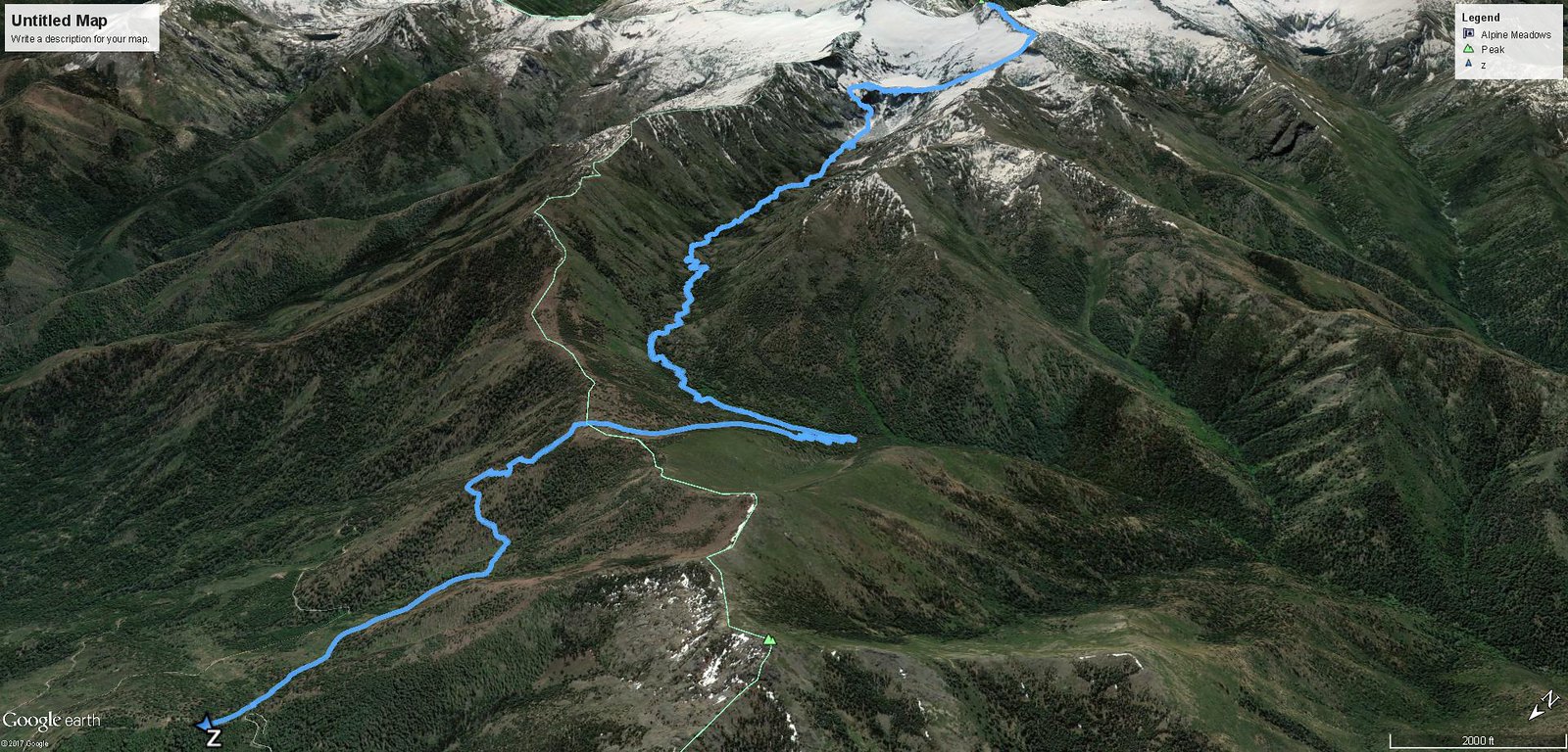
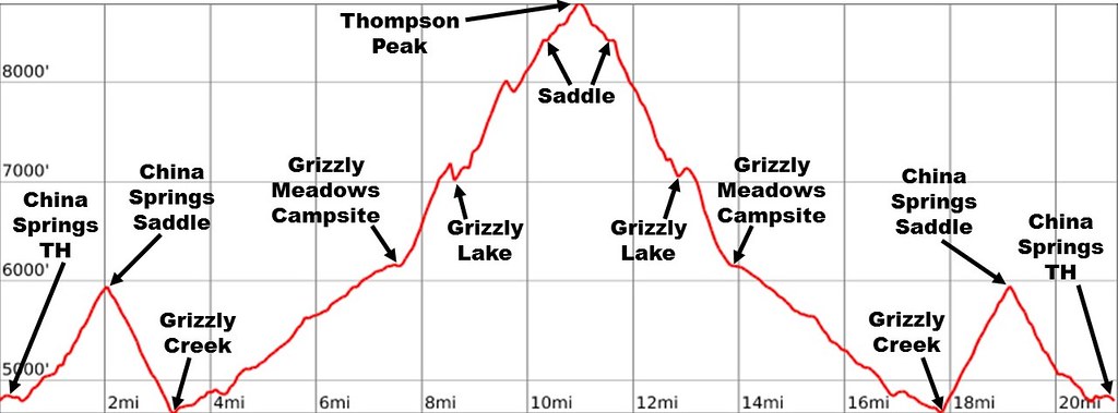
 Our track to and from Thompson Peak