GoalTechHikes God's Thumb - Mud or Trail...or both?
Posted: March 28th, 2017, 5:19 pm
God's Thumb
"Mud or trail...or both?"
3/28/17
Miles: 1.5
Time: 1 hr, 0 min
Avg MPH: 1.5
Elev Min: 95'
Elev Max: 420'
Total Vertical: 500'
Elev Change: 325'
Temp Low: 45
Temp High: 45
Other hikers: 0
Longest time without seeing a hiker: None
Wildlife: None
Opening Shot:
God's Thumb is super close access as it's at the end of the road just past "Roads End State Park" on the northern end of Lincoln City. It's a little tricky to find the trailhead as it doesn't really formally exist. There is no parking allowed at the end of the road. I parked in a single spot on the ocean-side of the street about 50 yards from the end of the road. Going back an additional 25 yards on the same side there appeared to be 2 more spots on the shoulder in gravel. With the exception of these few spots there was not much else until going all the way back to Road's End State Park about a 1/2-mile back. So with that in mind, I'd recommend going early or getting dropped off.
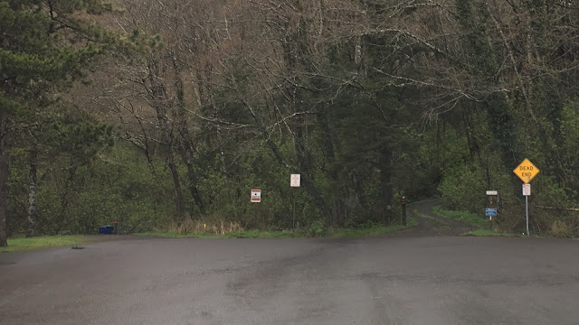
There are two gravel roads at the cul-de-sac end of the road that extend further. Take the left one and cross around the right side of the locked road-gate through a pedestrian pass-way. In this picture you can see the end of the road and the 2 roads I'm referencing.
Then walk up the gravel road about a hundred yards. There are two access points to the trail. The first one is the one I went on. I should have walked an additional 20 yards and taken the second one as it was the real trail and in better condition. If you walk any further on the road past these two points you will enter "no trespassing" private property.
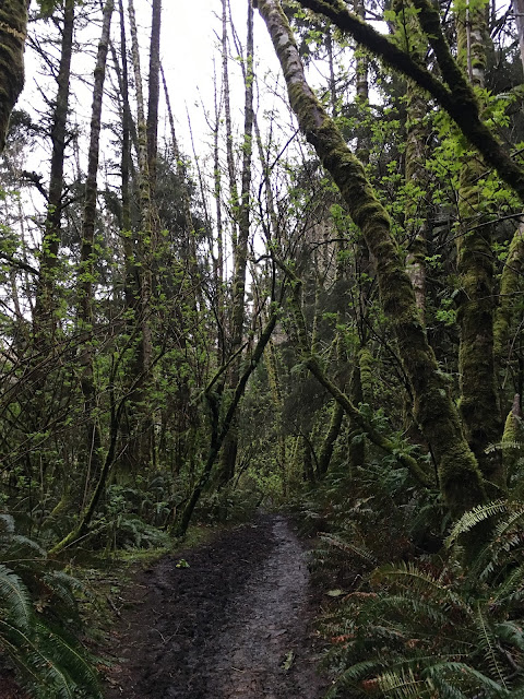
Below is the typical trail as the trail started. It wasn't too muddy...but the "best" was yet to come!
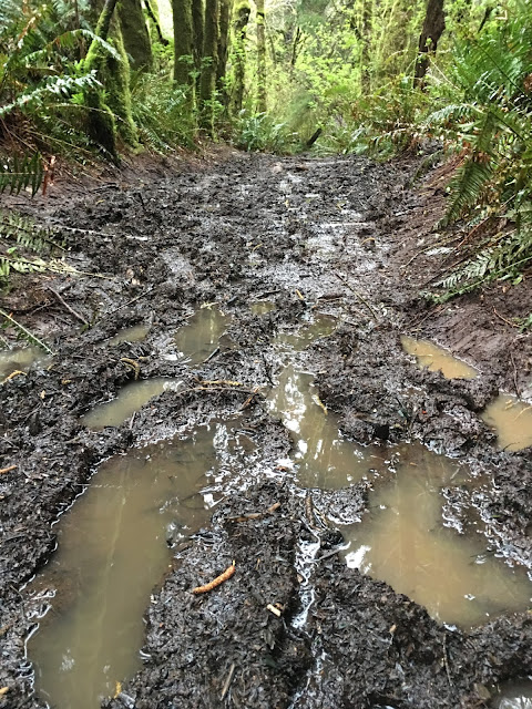
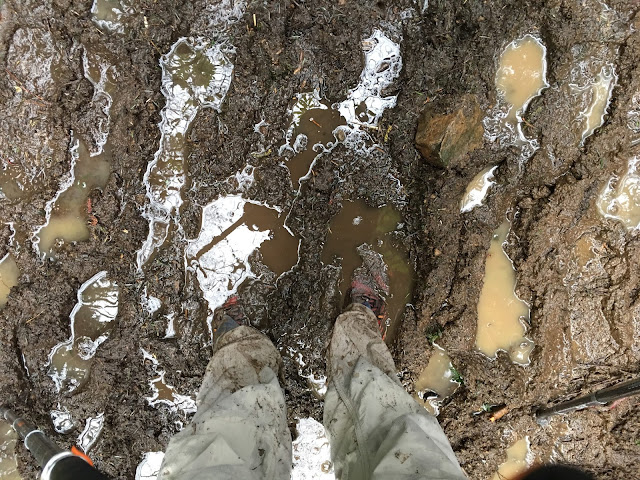
Here's that mud I know and love. About 1/2 the "trail" looked like this. I read somewhere that they only recommend doing this trail in the summer months as it can be pretty muddy...yep they were right. I can pretty much guarantee that you will slip and fall into the mud without trekking poles or soccer cleats as there were some steeper slick sections too.
Just before the open grasslands I caught a glimpse back to Lincoln City on this overcast, but dry morning.
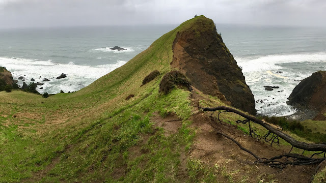
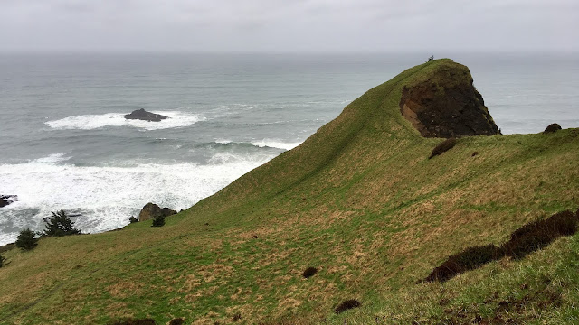
I broke out into the meadow and caught my first view of God's Thumb. It was a pretty cool sight to see it so prominently standing there.
As I approached the base of the final climb I looked down to see Road's End Point.

The meadow and the hill were actually in great shape and pretty easy to climb with firm footing. Again, the trekking poles were a nice insurance policy, particularly going down. Upon arriving at the top I could see over to the north, Cascade Head that I climbed up yesterday.
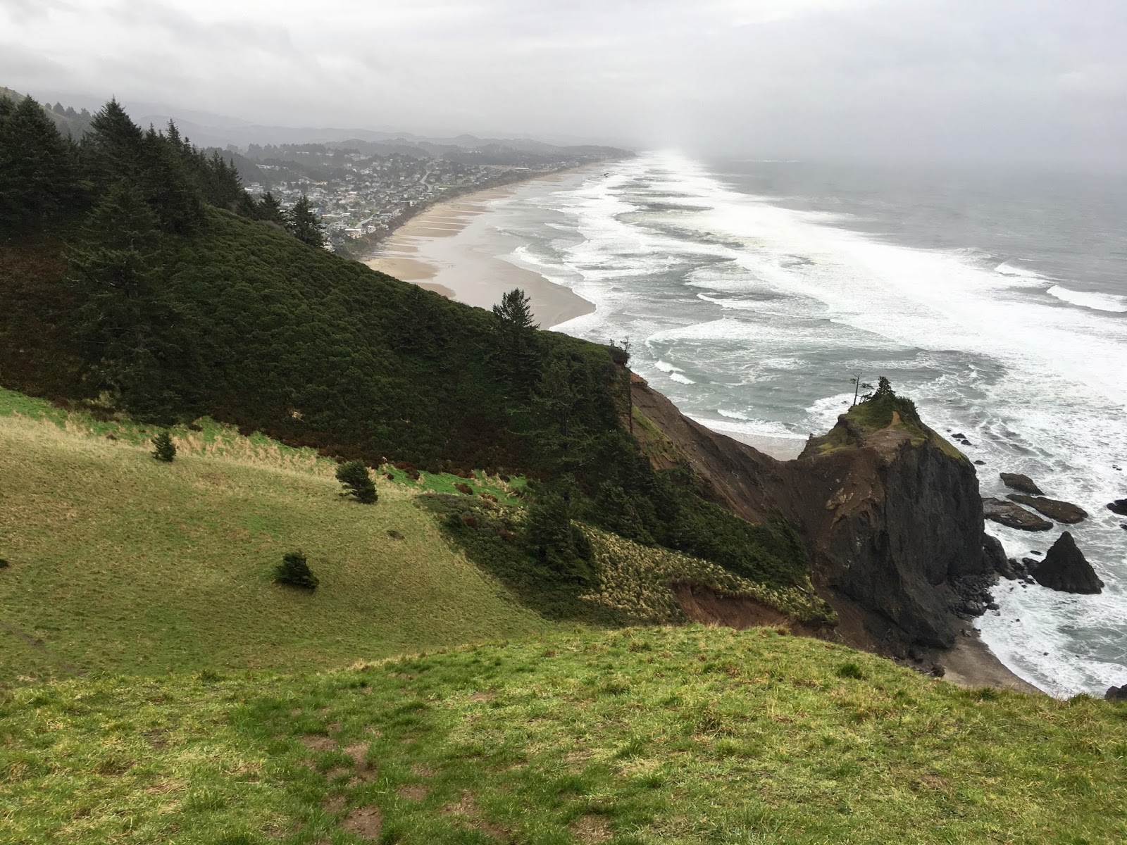
Looking back to the south I could see the sheer dropoff, the approach trail and back to Lincoln City.

And a tighter shot of Lincoln City and Road's End Point.
Instead of going back the way I came, I went along the ridge line a few feet down on the grass side as it didn't look super stable to me! This view shows the sheer drop to the north and the cool looking bay down below.

Just after this last view, I took an alternative social trail up into the high meadow which dodged some of the thick mud on the official trail. It provided some nice alternate views too.
I dropped back down to the main trail back into the sludge. This as got to easily be the most muddy hike I've ever done. Welcome to spring break in Oregon!
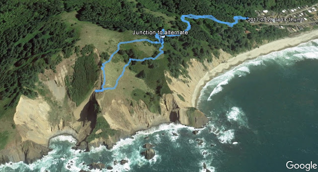
It's a great, short hike as long as the trail dries out and you can find a place to park. Here's a Google Earth image that shows my GPS track overlaid onto it.
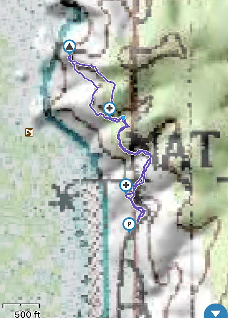
My topo track,
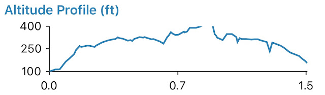
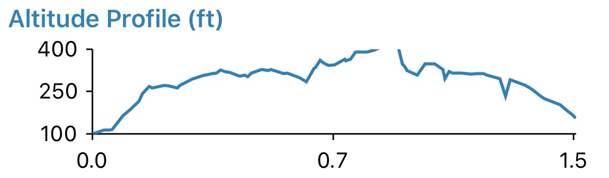
and elevation profile.
Here is my GPS track too if you'd like to download it for reference.
http://gpsfly.org/a/6975
Happy trails!
-Mike (aka GoalTech)
www.GoalTechHikes.com
@goaltechhikes (instagram)
"Mud or trail...or both?"
3/28/17
Miles: 1.5
Time: 1 hr, 0 min
Avg MPH: 1.5
Elev Min: 95'
Elev Max: 420'
Total Vertical: 500'
Elev Change: 325'
Temp Low: 45
Temp High: 45
Other hikers: 0
Longest time without seeing a hiker: None
Wildlife: None
Opening Shot:

God's Thumb is super close access as it's at the end of the road just past "Roads End State Park" on the northern end of Lincoln City. It's a little tricky to find the trailhead as it doesn't really formally exist. There is no parking allowed at the end of the road. I parked in a single spot on the ocean-side of the street about 50 yards from the end of the road. Going back an additional 25 yards on the same side there appeared to be 2 more spots on the shoulder in gravel. With the exception of these few spots there was not much else until going all the way back to Road's End State Park about a 1/2-mile back. So with that in mind, I'd recommend going early or getting dropped off.
There are two gravel roads at the cul-de-sac end of the road that extend further. Take the left one and cross around the right side of the locked road-gate through a pedestrian pass-way. In this picture you can see the end of the road and the 2 roads I'm referencing.

Then walk up the gravel road about a hundred yards. There are two access points to the trail. The first one is the one I went on. I should have walked an additional 20 yards and taken the second one as it was the real trail and in better condition. If you walk any further on the road past these two points you will enter "no trespassing" private property.
Below is the typical trail as the trail started. It wasn't too muddy...but the "best" was yet to come!

Here's that mud I know and love. About 1/2 the "trail" looked like this. I read somewhere that they only recommend doing this trail in the summer months as it can be pretty muddy...yep they were right. I can pretty much guarantee that you will slip and fall into the mud without trekking poles or soccer cleats as there were some steeper slick sections too.

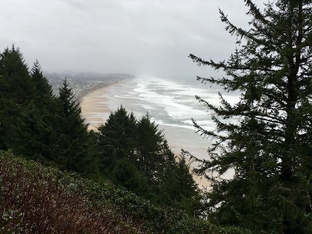
Just before the open grasslands I caught a glimpse back to Lincoln City on this overcast, but dry morning.

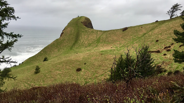
I broke out into the meadow and caught my first view of God's Thumb. It was a pretty cool sight to see it so prominently standing there.

As I approached the base of the final climb I looked down to see Road's End Point.

The meadow and the hill were actually in great shape and pretty easy to climb with firm footing. Again, the trekking poles were a nice insurance policy, particularly going down. Upon arriving at the top I could see over to the north, Cascade Head that I climbed up yesterday.

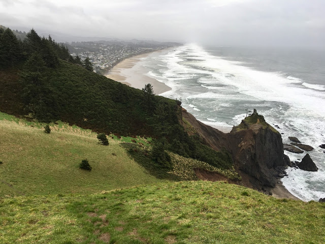
Looking back to the south I could see the sheer dropoff, the approach trail and back to Lincoln City.

And a tighter shot of Lincoln City and Road's End Point.
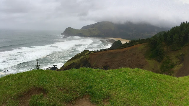
Instead of going back the way I came, I went along the ridge line a few feet down on the grass side as it didn't look super stable to me! This view shows the sheer drop to the north and the cool looking bay down below.

Just after this last view, I took an alternative social trail up into the high meadow which dodged some of the thick mud on the official trail. It provided some nice alternate views too.

I dropped back down to the main trail back into the sludge. This as got to easily be the most muddy hike I've ever done. Welcome to spring break in Oregon!

It's a great, short hike as long as the trail dries out and you can find a place to park. Here's a Google Earth image that shows my GPS track overlaid onto it.

My topo track,

and elevation profile.
Here is my GPS track too if you'd like to download it for reference.
http://gpsfly.org/a/6975
Happy trails!
-Mike (aka GoalTech)
www.GoalTechHikes.com
@goaltechhikes (instagram)