Goat Rocks Knife Edge via N. Fork Tieton Aug '15 Bike Hike

This forum is used to share your experiences out on the trails.
Post Reply
User avatar
TwoPaw
Posts: 113
Joined: July 28th, 2013, 10:30 am
Location: Portland

Goat Rocks Knife Edge via N. Fork Tieton Aug '15 Bike Hike

Post by TwoPaw » October 25th, 2015, 7:40 pm

Plenty written about PCT's Knife Edge in Goat Rocks so angle here is starting from North Fork Tieton trailhead.

Drove I5 North, 12 East, to NS 1200 / Tieton Reservoir Rd continuing onto 1207.
https://www.google.com/maps/dir/Portlan ... 230622!1m0

As of December 2014 Rd 1207 closed 2.5 miles before end/trailhead due to damage on Miriam Creek bridge. As this road represents a jutting finger into Goat Rocks Wilderness this is not end of the world. Road still open to bikes which I chose to do to the actual trailhead.
testP1030068.jpg.jpg
Gate at Rd 1207 Closure
Road surface after this gate remarkably smooth and grade very gentle. Reached trailhead, stashed bike, and signed in.
testP1030072.jpg.jpg
After a very short segment I veered right onto trail 1118 - N. Fork Tieton
testP1030075.jpg.jpg
This trail climbs steadily on a very well graded path beneath a nice canopy of trees providing shade even midday. The first couple of miles had ample and frequent water but higher up things dried up due to low snow/rainfall this past winter. I saw no one but heard a couple of rifle reports somewhere in the canyon. Although forest fires were burning to the north and south skies were still clear overhead at this point.
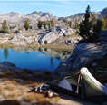
Only horseprints were visible on the trail until 1118 met PCT where I turned directly south. After awhile I passed nearly dried up Lultz Lake until I veered left down to McCall Basin. This junction is unmarked but sign down the trail informs forks this is now a dead end in the Basin. More horseprints as I descended into the flat of the pleasant basin until I sited in distance the animal I'd been following - tethered up. I backtracked a little bit to a campsite near a still flowing stream.
Evening presented a pretty sky with some smoke to the east, the moon, and clouds above:
test_1030082.jpg.jpg
Next morning I heading back up out of Mccall Basin, then continued south on PCT, soon clearing above treeline with a view of Mt. Rainier.
testP1030096.jpg.jpg
Now smoke moved in increasing force as I ascended towards Elk Pass where I passed a couple with a small horse camp. Staying due south on PCT I navigated the knife's edge with limited, surreal but limited views, passing some grumpy PCT through-hikers.
testP1030107.jpg.jpg
There were a fair number of folks on the trail now, some totally unaware that yes this was a bad fire season. (One upside: the smoke did screen also the sun's heat.)

With no sweeping views to be had I stayed on the primary PCT trail and ignored the alternate route up Old Snowy.

My plan had all along been to overnight past the Knife's Edge and return the same day, so I still had hope the winds would shift the next day. Passing the other approach to Old Snowy I descended the bone dry landscape offering campsites left and right next to barren creeks. Finally mid afternoon I set up camp next to the gushing creek just below junction with trail 96.

Between a full moon and the smoke stargazing was diminished but by near morning things darkened, and brightened. The stars came out in full force and I awoke early, decamped, and headed back north toward.

Blue skies! I was in the world we all love at Goat Rocks!
testSuperPano2.jpg.jpg
I had all day to take the Alternate PCT route over Old Snowy and back to McCall basin. Pure bliss.
testP1030151.jpg.jpg
Fire and clouds to the south near Mt. Adams.
I meandered back down from Elk Pass to the pleasant meadows below for a nice creekside lunch.
testP1030209.jpg.jpg
testP1030207.jpg.jpg
That afternoon I returned to McCall Basin this time exploring further to find the falls
testP1030216.jpg.jpg
and a nice creekside campsite.
testP1030214.jpg.jpg
Final Day a few very light sprinkles as I returned to the trailhead, biked back to the car and was on the road early afternoon.

I like this route as an alternate approach to the Knife's Edge. Normally it would have been far less crowded if not for the herd of PCT thru-hikers. And the distance Elk Pass is fairly efficient. McCall basin is also pleasant and appears to be far less used now that an extra 2.5 miles has been added to the journey.
Attachments
testPanorama1.jpg-1.jpg
testP1030070.jpg.jpg

User avatar
RobinB
Posts: 803
Joined: September 9th, 2013, 11:29 pm
Location: Portland, OR

Re: Goat Rocks Knife Edge via N. Fork Tieton Aug '15 Bike Hi

Post by RobinB » October 26th, 2015, 12:15 am

Very nice! I'd been wondering about that approach for a while - thanks for the report!

backcracker
Posts: 38
Joined: July 25th, 2013, 11:55 am
Location: Tri-Cities

Re: Goat Rocks Knife Edge via N. Fork Tieton Aug '15 Bike Hi

Post by backcracker » October 27th, 2015, 6:53 pm

I day hiked the N Fork Tieton to PCT and headed South a bit in 2013 and also rode in on my mtn bike. Crossed paths with one elderly through hiker (Tic Tock) who said there were only 8 PCT hikers ahead of him. Biking in and out is the only way to go. When I returned to my bike which was chained to a tree and well hidden from view there was a small rock placed on the seat which was kind of eerie. Cycled past few backpackers exiting and they were drooling as I descended by effortlessly.

Thanks for the report.

Post Reply