The Mountain Lakes Wilderness (not to be confused with the Sky Lakes Wilderness just to the N) is an exactly one section square (36 sq mi) area that encompasses several lakes within an old (if it were not, you wouldn't be reading this TR) caldera. Certainly the "squarest" wilderness area in Oregon.
We had previously explored its southern side via the Clover Creek TH enroute to a climb of its high point - Aspen Butte (Aspen Butte TR). Aimless then posted a TR of an overnight backpack via the Varney Creek TH (Harriette Lake TR) and so we added that to our "to do" list. The Mountain Lakes Loop is Hike #53 in Sullivan's Southern Oregon guide (3rd edition).
With the Loved One out of action with a knee injury, it fell to me to explore Varney Ck and hike the Mountain Lakes loop - which circles the lakes in the core of the wilderness - alone ( ). With air temps in the valley hitting triple digits, I thought it would be cool enough over 6,000' for a comfortable hike. This was somewhat true until the afternoon when it got pretty hot at altitude (near 90F), a heat haze formed, and smoke from nearby wildfires started rolling in. But it was cool when I started up the gently climbing Varney Creek trail (USFS #3718) through open forest,
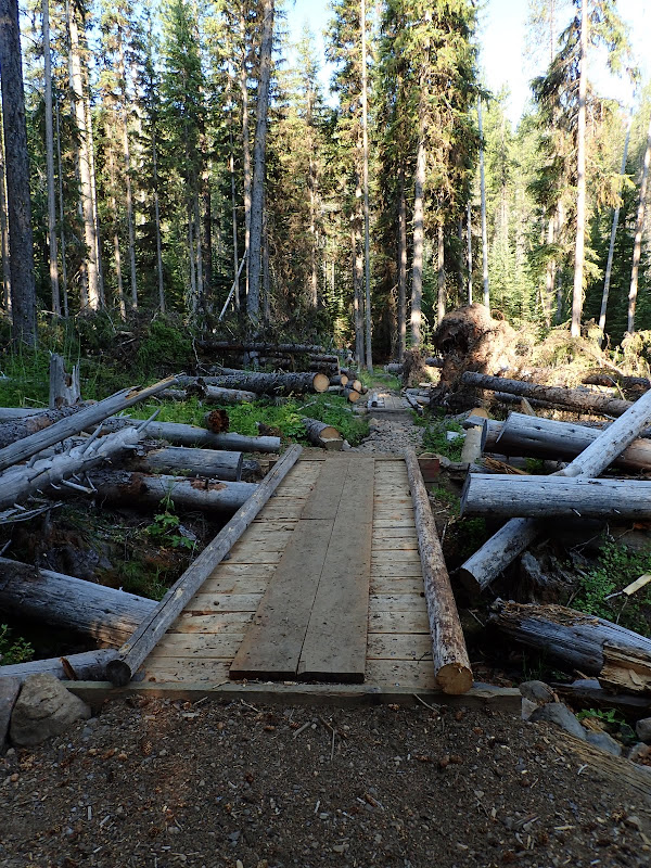
an area of intense trail maintenance (lots of trees cleared and two new bridges built),
and across small meadows still showing some greenery (but looking wilted by afternoon),
to its junction with the Mountain Lakes Loop trail (USFS #3727) at about 6,700'. I did the loop counter-clockwise, so I soon came to Eb Lake (Greyback Mtn on the horizon),
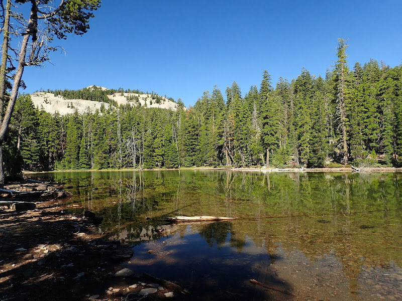
and Zeb Lake (Whiteface Pk in the distance). There are a few small campsites at these lakes.
The trail then climbs up to the saddle on the W side of Whiteface Pk and the junction with the Mountain Lakes trail (#3721) coming in from the N. This is the one place where you can get a clear view (but with smoke haze) of Mt. McLoughlin to the N.
From there, the loop trail heads SE, first dropping slightly and then climbing back to the ridge at about 7,200' for a view of Harriette Lake from above.
I should note that the way that trail #3727 shows on even the most current maps is not exactly how it plays out on the ground. Specifically, the maps show the trail contouring from below Whiteface Pk, past Pt 7514, to the ridge above Harriette Lk. It doesn't, as this would involve traversing some extensive boulder fields, across which I could find no evidence of a trail, old or new. Instead the loop trail drops down to about 6,800' (to get around the boulders) and then climbs back to the ridge. From its high point on the ridge, the loop trail then drops down into the lake basin, becoming quite rocky in the process. With the exception of the lakes themselves, it was bone dry in the forest, with many places that had known water in the past but had seen none recently,
or were just patches of weed-choked water.
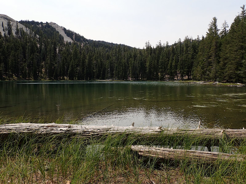
Harriette Lk is the largest in the wilderness, and was cool, clear, and inviting on what was becoming a hot day (yes, there was some splashing). The shores are rocky but I saw 2-3 decent campsites along the N shore.
The loop trail then climbs out of the Harriette Lk basin,
before descending past Lake Como (2-3 small campsites),
to its junction with the Varney Ck trail. Then it was 4.5 easy but waterless miles back to the TH under a hot and hazy sky. Overall, a fun hike (17 mi RT, 2900' EG) through a pretty area but one that is now so, so dry - you can almost feel the forest crackle like old, dried paper as you hike through it. Definitely worth a return visit (via the Mountain Lakes TH?) if/when we get some rain to freshen it up a bit.
Mountain Lakes Loop (Mountain Lakes Wilderness) 30-Jul-2015
-
- Posts: 14
- Joined: June 26th, 2015, 1:55 pm
Re: Mountain Lakes Loop (Mountain Lakes Wilderness) 30-Jul-2
Thanks for another solid report Marmot. I recently took the same route trying to escape the valley heat and it worked ok, although that was after and before the heat of the day. How were the bugs? You don't mention them so I'm guessing not too bad? My sister was looking for a loop hike with some water and I mentioned this trail but cautioned that the mosquitos could be intense. On my trip (about a month ago) I couldn't stop for 5 seconds without getting overwhelmed by mosquitos and was constantly swiping/slapping at my arms and legs while walking for the entire trip. I could imagine that this would be a great hike to a swim if the bug pressure was low.
Thanks
Thanks
Re: Mountain Lakes Loop (Mountain Lakes Wilderness) 30-Jul-2
Thanks! There were a few mosquitos at the TH and along the Varney Ck trail in the morning but, after that, essentially none. I stopped for lunch up on the ridge and there were no bugs at all. Same for down at the lakes in the afternoon. Maybe they all come out in the evening but my guess is that all the recent heat/dryness has taken its toll on the bug populations.siskiyoudaniel wrote:Thanks for another solid report Marmot. I recently took the same route trying to escape the valley heat and it worked ok, although that was after and before the heat of the day. How were the bugs? You don't mention them so I'm guessing not too bad? My sister was looking for a loop hike with some water and I mentioned this trail but cautioned that the mosquitos could be intense. On my trip (about a month ago) I couldn't stop for 5 seconds without getting overwhelmed by mosquitos and was constantly swiping/slapping at my arms and legs while walking for the entire trip. I could imagine that this would be a great hike to a swim if the bug pressure was low.
Thanks
-
- Posts: 14
- Joined: June 26th, 2015, 1:55 pm
Re: Mountain Lakes Loop (Mountain Lakes Wilderness) 30-Jul-2
Good to know. Thanks!
Side-note; I'm planning to hike the Cook and Green loop Sunday and of course you've already done it so thanks for the advice to go clockwise and on "reliable" water sources (we'll see what's running this time of year). If I see anything noteworthy I'll write it up.
Cheers
Side-note; I'm planning to hike the Cook and Green loop Sunday and of course you've already done it so thanks for the advice to go clockwise and on "reliable" water sources (we'll see what's running this time of year). If I see anything noteworthy I'll write it up.
Cheers