Personally, that's the sort of thing that gets a hike on my shortlist, but when I arrrived at the Tooth Rock Trailhead (oddly signed as the "Toothrock Trailhead" by the State of Oregon) at 10 am on Sunday morning, there were only two other cars in the parking area. On my six-hour journey up to the ridge and back I met only two couples -- and this was on a warm, sunny weekend day following a fairly gray and unseasonably drizzly week in June, when I would expect any trail in easy reach of the Portland metro area to be pretty crowded (at least by Gorge terms).
So if you like your solitude on the trail, here's my advice: Find a trip that starts out with a nice, long Forest Service or logging road, and with virtually nothing in the way of waterfalls or views. As with Herman Creek (where so many wonderful trails emerge from Herman Camp at the top of a disused logging road), the walk up to Wauna Point starts with a cardio warmup on Forest Service Road 777 -- the most interesting thing you'll see along here is a pretty good look at Bonneville under a swath of power-lines:
That long, slightly dull walk (as with Herman Creek, up to about 1,000 feet) is a guaranteed crowd-killer -- especially when the intersection with Gorge Trail 400 arrives (around 450 feet), promising an easy traverse to Wauna Viewpoint and Eagle Creek. I was bound for Wauna Point proper, so I skipped this and continued up Road 777 up to the Tanner Butte Trailhead (trail 401), where the payoff begins.
Within the first few minutes of heading up the Tanner Butte Trail, no less than four small waterfalls come into view, two of them virtually side-by-side (and difficult to photograph, separately and particularly together):
These two waterfalls occur at the confluence of two creeks -- neither one Tanner Creek, as it turns out. As the trail continues, it passes two more waterfalls. You can literally stand right next to the top of one, while the other comes into view as the trail drops into the creek and picks up on the other side.
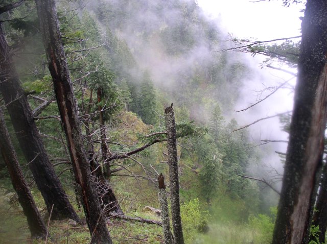
From this point, the trail continues above the creek, where at least one more waterfall can be glimpsed, and perhaps two more exist. Reality intrudes again with the return of power-lines and a service road (power-lines actually cross this route five times), but the trail picks up once again, ridge-running into the high forest. Up here, this really is a classic Gorge trail, with trees and a general sense of quiet and a grade that's not too steep.
I earned bonus points by spotting this Gorge landmark through the trees with my zoom lens (you get bonus points if you can name it):
But of course I wasn't just snapping photos in the woods -- I was looking for the mysterious Wauna Point. I set my altimeter alarm for 2,700 feet, and just as it went off I found myself looking at a roomy, inviting campsite:
A helpful sign indicated that the Tanner Butte Trail continued in the same general direction I was already traveling, so I poked my way down the campsite's cutoff trail, where I found a cairn, a sign for Wauna Point, and a "Trail Not Maintained" sign that had seen better days (it's currently propping up a small, windfallen tree):
From here, the route is definitely not a USFS trail -- it's not hard to follow, but it's really covered with a lot of overgrowth and deadfall as it clambers along a level area above the ridge.
Now here may be the silliest sign in the Columbia River Gorge. For starters, it says "Wauna Point," but there's nothing actually here. Even worse, it says "1300 FT," which is certifiably insane. This is actually closer to 2,600 feet. Thus, was this sign actually created for Wauna Viewpoint (actually 1,050 feet) and placed here? Or is it a "typo" of some kind? And what rational, sentient person actually brought this thing all the way up here and nailed it to a tree with "1300 FT" carved in to the wood as plain as the clouds in the sky?
In any event, if you head up here, remember this sign, becuase it's important -- this is where our adventure to Wauna Point becomes a tale of two trails. The trail forks here.
Head left if you'd like to get a look at the "official" Wauna Point trail. It isn't on the Green Trails topo, although a posting at the Tanner Butte Trailhead suggests this trail might be #402 -- in either case, prominent numbers for something as forsaken as this scramble, because once you work your way down the ridge and crawl under a large log, you'll come to a point where the trail has nearly washed out:
This section is not for anyone with pets, or without trekking poles -- the dropoff looks a bit steep, but there are glimpses of Mt. Adams and the Bridge of the Gods in here as well:
And that's about as good as the "views" get -- the footing gets a bit better along the descent, but it quickly turns into a scramble, particularly with a steep descent to the outer ridge:
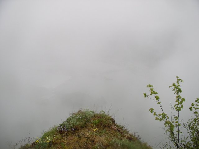
From here, I did my best to figure out where the trail would go. At one point it appeared to switchback down the east side of the spine for a bit, but this turned into a dead end. The spine itself narrows down to just a few feet across, well short of the outermost promintory. And it was there that I really couldn't see one more place to set down a boot:
Time to head back uphill. But now, instead of turning left at the "1300 FT" elevation, it was time to turn right. This continuation of the campsite spur trail is charted on the Green Trails topo, as #401D. From here, I walked about 200 yards and found pleasant, semi-open spot on the top of a cliff (in fact, almost directly above the washed-out trail a few hundered feet below). It sure isn't the best viewpoint in the Gorge, but you can look down on the Wauna Point ridge through the trees, and even get a look at Cascade Locks, Mt. Adams, even Mt. Rainier on a clear day.
And if you stop for lunch here, it's a pretty good bet that it won't be crowded.
-Robert