A bit late in getting this posted: had a nice day at Siouxon Creek last Sunday with my brother-in-law, David. Beautiful canyon, very nice trail and a paved road (albeit with a few potholes) right to the trailhead, so it was downright civilized! We were the second car there, but I don't think there more more than 5 groups all day - including one large group (seemed to be an organized hike) and two sets of mountain bikers (this is a shared trail). I was also testing my new backpacking tripod, but only put it to use a couple times -- the combination of high water levels and not wanting to keep David waiting inspired me to treat this mostly as a scouting trip, and head back up there alone sometime later in the spring. Lots of waterfalls to photograph!
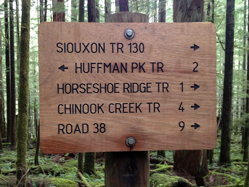
The Gifford Pinchot also has a lot of economic stimulus signage going on -- albeit, with better editing control than we see at the Mount Hood NF and Gorge!
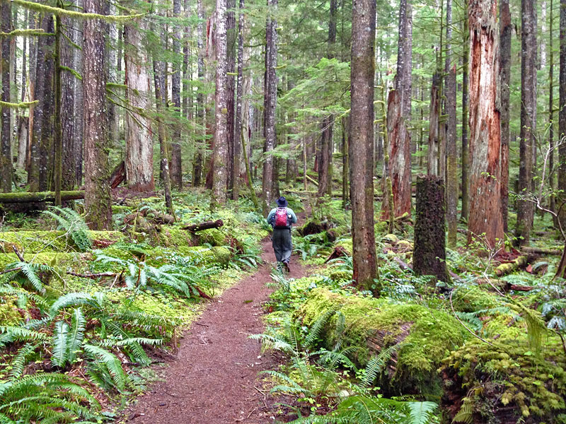
We did the Sullivan-recommended hike to Chinook Creek. Sullivan describes this as an "old growth" forest, and it certainly was before the Yacolt Burn, 110 years ago! Today, it's an attractive, recovering forest with some really magnificent skeletons of the ancient forest that burned scattered throughout the hike:
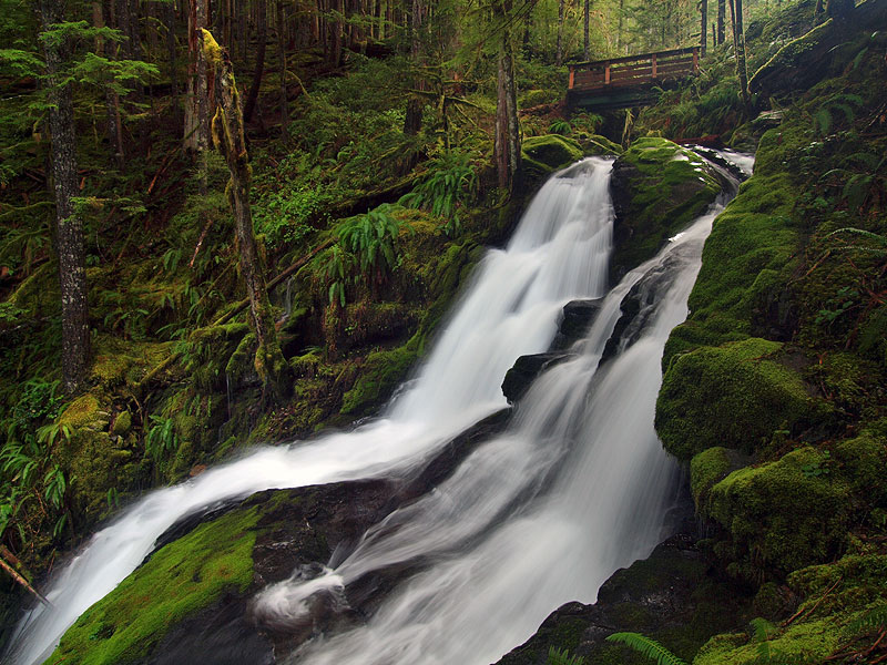
The first falls is on a pretty tributary called Horseshoe Creek, which is crossed by a sturdy new footbridge built on I-beam supports -- also courtesy the American Recovery Act, I suspect. This is the top half of the falls (with the bridge), and there's a spur trail a few hundred yards beyond the bridge that traversed down to the base of the falls, at the junction with Siouxon Creek -- saved that for my return trip:
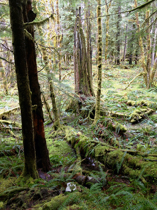
Some beautiful bogs along the trail -- this one used to be a cedar swamp before the Yacolt Burn, but now is a beautiful bigleaf maple swamp -- with a picturesque cedar skeleton haunting the middle of it:
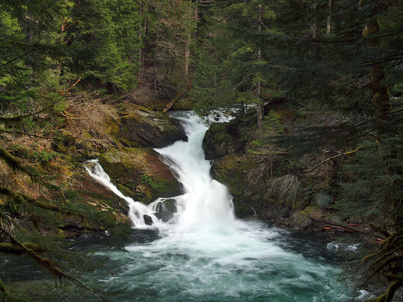
Siouxon Falls is a large, thundering drop that seems lifted out of the Rockies or Sierras -- looks to be a prime summer swimming hole, too, based on the boot paths dropping down to the splash pool:
The tributary crossing just short of the Chinook Trail junction proved to be just as slippery and hazardous as Sullivan warns in his guide (a lot of water flowing over sloping bedrock). We opted to ford it on the way up, but on the advice of a pair of mountain bikers, followed a rather sketchy log crossing a bit upstream on the way down... I'd stick with the wet feet, given the choices..! Oddly enough, there is an elaborate bridge over Siouxon Creek at the start of the Chinook Trail -- just 50 feet beyond -- so who knows, maybe the Gifford Pinchot will bridge the slickrock stream, someday, too?
We hiked the short distance to Chinook Falls, where the Chinook Trail makes a bridgeless crossing and heads up the canyon wall. It would have been a thigh-deep ford this time of year, however! Which also meant that I didn't really have a good way to photograph the very impressive Chinook Falls -- it was thundering, and the near-side views were pretty much at the base of the falls, in the spray zone... so, that will have to wait until next time, too!
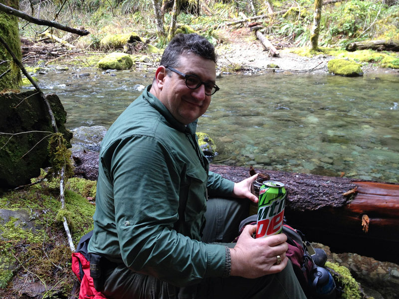
We had a couple of super-sized Mountain Dews and lunch on the bank of Chinook Creek to celebrate our brave foray into the heart of Clark County... (..that was for Karl...)
...then reversed course, and had a nice walk back to the car. Most of my photos on this trip were with my iPhone, so I thought I'd try a Mayem-esque trailhead shot at the conclusion of the hike...
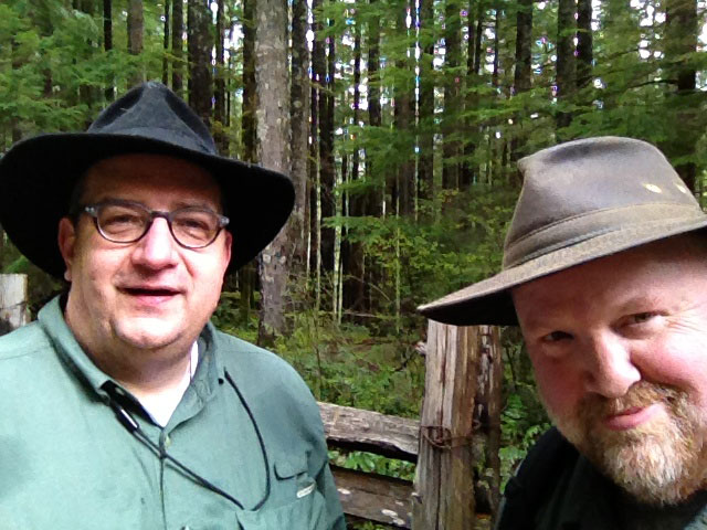
Ack! ...okay, so we're not going to do THAT again..!
Nice hike, about 90 minutes from Portland, a tad confusing to follow the Sullivan instructions, however. The Google Maps lady helped us at several of the poorly/unmarked intersection..!
-Tom
Siouxon Creek Trail (April 14)
- Splintercat
- Posts: 8334
- Joined: May 28th, 2008, 10:03 pm
- Location: Portland
- Contact:
Re: Siouxon Creek Trail (April 14)
Nice! Thanks for posting this, Tom. Any guesses how far you went? Probably not a lot of elevation, right? I still haven't been up there, and really need to do that. Sounds like you go prepared to get wet, eh?
One small step for man, ...Splintercat wrote:our brave foray into the heart of Clark County... (..that was for Karl...)
Karl
Back on the trail, again...
Re: Siouxon Creek Trail (April 14)
You guys could be brothers! Interesting that they are using plywood for their signs. Siouxon is on our list, but haven't been able to figure out driving directions.
- Splintercat
- Posts: 8334
- Joined: May 28th, 2008, 10:03 pm
- Location: Portland
- Contact:
Re: Siouxon Creek Trail (April 14)
According to the USFS signs, Eight miles up and back to Chinook Falls, and I think Sullivan said 700 feet elevation gain? Very modest -- a really nice, relaxed hike. I think I'll take along some flip-flops next time for creek fording -- both for the slippery bedrock crossing and to get a good shot of Chinook Falls (Sullivan describes Chinook Creek as "calf-high", though it's twice that now).Probably not a lot of elevation, right? I still haven't been up there, and really need to do that. Sounds like you go prepared to get wet, eh?
Interesting that they are using plywood for their signs.
Yes, not sure what to make of that. I'm sure it's cheaper, but hard to say what the elements will do to those..?
It's not too bad. You take the Battleground exit on I-5, then drive away to Battleground, where you turn left on Highway 503 and stay on it through multiple doglegs until you get to the crossroads of Chelatchie. Turn right here... then hope that you have cell service to navigate the (paved all the way) logging roads to the trailhead! We had more trouble staying on Highway 503 (signs are not obvious!) than in navigating the forest roads..!Siouxon is on our list, but haven't been able to figure out driving directions.
Tom
Re: Siouxon Creek Trail (April 14)
Thanks for the reminder that Siouxon is a great mid-elevation hike to do at this time of year. I wonder why Sullivan calls it "old growth" other than that the forest has naturally regenerated since the fire. Up on Horseshoe Ridge, however, there are quite a few big trees that escaped the blaze, including some stunning hemlocks.
- Splintercat
- Posts: 8334
- Joined: May 28th, 2008, 10:03 pm
- Location: Portland
- Contact:
Re: Siouxon Creek Trail (April 14)
Maybe because it's such a nice rainforest? The skeletons are so abundant that it does sort of have an old-growth feel. Some are upwards of 40 feet tall, after a century! I meant to grab a photo on the way out, but as you descend the last few hundred yards on the access road, there's a 50+ foot tall skeleton with a good-sized (15 feet?) hemlock growing out of the top -- a perfect little Christmas tree on a very tall pedestal!I wonder why Sullivan calls it "old growth" other than that the forest has naturally regenerated since the fire.
Sullivan describes the hike ending at Chinook Falls, but after looking at Bryan Swan's site, I think I'll add the roughly 3 miles RT next time and visit Middle Siouxon and Upper Siouxon falls -- both are the more subtle, less photographed drops that I really enjoy visiting.
Amazing that the Siouxon canyon wasn't logged -- presumably because of the burn -- but it's such a stark difference from the surrounding sea of stumps! (especially on the dreaded BLM land that fringes the GF boundary).
Tom
Re: Siouxon Creek Trail (April 14)
Great pictures, thanks for sharing!
- Sean Thomas
- Posts: 1647
- Joined: February 25th, 2012, 11:33 pm
Re: Siouxon Creek Trail (April 14)
Great photos, Splint. The lunch spot on Chinook Creek looks awesome as well as the mayhem style parting shot.
- BrianEdwards
- Posts: 2405
- Joined: February 2nd, 2010, 1:32 am
- Location: Oregon City, OR
- Contact:
Re: Siouxon Creek Trail (April 14)
A Splintercat in the Gifford Pinchot? That's not native territory. Good thing there's photos, or it never happened!
The Siouxon was a great choice, especially for one that likes a few waterfalls along their hike. The shot with the falls under the bridge is one that I could've named the photographer in seconds. It's got the greens I'm envious over, and the water is perfectly silked with no blue saturation. Nice!
Clackamas River Waterfall Project - 95 Documented, 18 to go.
Re: Siouxon Creek Trail (April 14)
Great photos, Tom. The falls under the bridge shot is particularly nice. What are you using as your new tripod, and how do you like it?
Looks like a great area to hike. I'm going to have to get up there soon; for some reason Siouxon Creek is a hike I've never done. In fact, my ignorance of the area even extends to the name--how do you pronounce Siouxon?