Goodman Creek/ Eagle's Rest

This forum is used to share your experiences out on the trails.
Post Reply
User avatar
jessbee
Posts: 877
Joined: May 28th, 2008, 10:03 pm
Contact:

Goodman Creek/ Eagle's Rest

Post by jessbee » March 19th, 2013, 9:56 am

Hardesty Mountain Trail> Goodman Creek Trail > Eagle’s Rest Trail and back

13.5 miles | 2100′ ele. gain | 6 hrs.
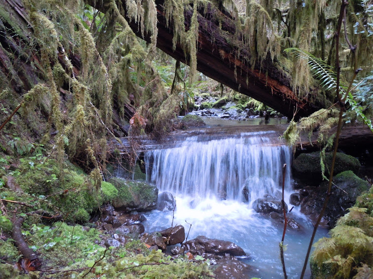

Image

Photo Album

Numerous trailheads dot the main road heading east from Eugene towards Oakridge. From Portland, it’s a bit of a haul…but from Corvallis, this is a fairly short drive. So we decided to explore the Goodman Creek Trail from Hardesty Trailhead.

Image

Sunshine filled the morning. This was a welcome change from the past few days. We began on a muddy trail that passed through a corridor of tall trees. The trail had many ups and downs, getting us warmed up pretty quickly. We veered onto the Goodman Creek trail and began to spot the early bloomers: Indian plum, trillium, and what I think was snow queen.

Walking through the forest was pleasant and scenic. The creek rushed along calmly as the trail alternately veered towards it, then away, and back again. We crossed the stream twice, then started to gain a little more elevation. A few boggy areas were dotted with skunk cabbage. The moss and lichen on the ground and in the trees seemed to glow green. The moisture in the air settled on the surface of all the vegetation, making everything glisten.

Image

It started to snow. I zipped up my rain shell and we pressed on. Eventually we passed by a stout 3-sided shelter that could comfortably sleep 4 or more people. From there, we knew we didn’t have much further to go.

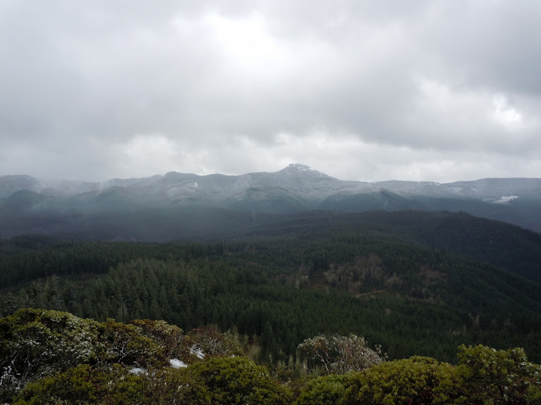
The snow fell a little harder now as we made the final push to the top. We crossed a road and another parking lot, noting that some people could choose to hike to the viewpoint with little effort at all! The summit area was open and rocky. Manzanita clung to the clifftop. We savored a few minutes of views at the top before a couple of ladies joined us there. We sat to eat lunch, but the chilliness of the air bore through our skin and soon forced us to get moving.

Image

On the way down, we passed several pairs of hikers who seemed to have no idea where they were, how long the trail was, or where they were going. “Is this a loop?” someone asked, 4 miles up this out-and-back trail. It’s hard to believe more people don’t get lost out there. Yikes.

Image

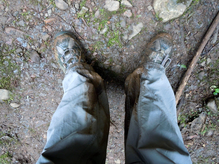
Eagle’s Rest was a wonderful viewpoint hike with lots of access options. I thought the first few miles of trail was the prettiest, so taking the longer option was the way to go. The grade never got very steep, the forest was always lovely, and the flowers were just starting to bloom. Sure, the trail was muddy, but at least it wasn’t raining.

Since the trails around Oakridge are popular with mountain bikers, I’d avoid this trail pretty much most of the year. We only saw two mountain bikers near the end of the trail as we were walking out. They were on a short viewpoint spur so we didn’t really get in each other’s way paths. It was perfect.
Will break trail for beer.

Blog and photos

User avatar
Sean Thomas
Posts: 1647
Joined: February 25th, 2012, 11:33 pm

Re: Goodman Creek/ Eagle's Rest

Post by Sean Thomas » March 19th, 2013, 3:28 pm

Nice photos and description, jessbee. Looks like maybe an early morning/weekday type of hike to avoid the bikers?


I like the flower pics and the newt photo from your album too. That newt looked like a biggen!


I wasn't sure what the little purple flowers were either on a hike last weekend but they turned up in Pojar/Mackinnon's Plants of the Pacific Northwest Coast under Spring Queen.

And here: http://www.nwplants.com/business/catalog/syn_ren.html


The more commonly used name seems to be Snow Queen. It looks like they're even available in nurseries :)

http://www.nwplants.com/business/catalog/syn_ren.html

User avatar
jessbee
Posts: 877
Joined: May 28th, 2008, 10:03 pm
Contact:

Re: Goodman Creek/ Eagle's Rest

Post by jessbee » March 21st, 2013, 7:38 am

Hey, thanks Sean. Yup--definitely an early morning or mid-week hike once the weather starts getting nicer and the trail dries up.

Those first few flowers of spring are always a nice reminder to start packing the ID book and start sharpening my flower ID skills :) Every year I learn a few more so my base knowledge grows and grows. I'm heading to the desert next week so I hope to see some new flowers there.
Will break trail for beer.

Blog and photos

bb12creek
Posts: 5
Joined: February 15th, 2013, 12:05 pm

Re: Goodman Creek/ Eagle's Rest

Post by bb12creek » March 22nd, 2013, 12:35 pm

Glad you enjoyed the Goodman and Eagle's Rest Trails. I live in Eugene and enjoy hiking and mountain biking in and around the state. The mountain bike club that I belong to, Disciples of Dirt, has a very well established relationship with the Middle Fork District of the Willamette National Forest and we do a lot of work on the trails. You probably noticed that parts of the Eagle's Rest Trail (above the first dirt road crossing) were quite beat up as a result of this winter's work. That will heal as things dry out and the trail will be better drained and more sustainable in years to come as a result.

Hiker / biker interactions on the Goodman Creek Trail and the Eagle's Rest Trail generally occur on the lower stretches of the Goodman Creek Trail. Early morning and mid week is of course the best time to avoid other trail users of any kind. As someone that enjoys hiking and trail running as much as mountain biking, I understand the concerns of trail users on foot. The Hardesty Mt Trail is where someone on foot would be more likely to have a negative interaction with a biker. It is a very narrow trail that can be very fast on a bike. It also receives a lot of biking pressure. Groups like the Disciples of Dirt go out of their way to promote proper trail etiquette. There is still a lot of work to be done, but we are getting there. Unfortunately, it only takes one inconsiderate group on bikes to create a negative interaction. The whole trail network around Hardesty Mt benefits from being accessible by multiple user groups.

Check out the Lawler / Patterson Mt Trail sometime. It sees less bike pressure, passes some great views, and gets into very cool old growth. The whole trail from the lowest access is 7 miles or so, with an upper access allowing for a shorter hike to a cool shelter and viewpoint in awesome woods. The whole trail is used by bikers, but it sees quite a bit less riding than Hardesty Mt proper. Very worthy hike. Upper parts should be snow free by the end of April.

I hope to post some hiking trip reports soon!

User avatar
Crusak
Posts: 3617
Joined: August 6th, 2009, 7:33 pm
Location: Oregon

Re: Goodman Creek/ Eagle's Rest

Post by Crusak » March 23rd, 2013, 9:19 pm

Nice TR for what looks like an interesting trail. Your current location is definitely closer to lots of amazing hikes than the Portland metro area is!
jessbee wrote:On the way down, we passed several pairs of hikers who seemed to have no idea where they were, how long the trail was, or where they were going. “Is this a loop?” someone asked, 4 miles up this out-and-back trail. It’s hard to believe more people don’t get lost out there. Yikes.
On a few hikes in the gorge I've printed a couple of extra maps, just in case I come across people who seem a little turned around (but who could likely get out on their own, with a little direction). It is amazing to me that we don't see more lost hikers in the news. Most of them must find their way out somehow, even if it takes them a while.
Jim's Hikes

Solvitur Ambulando

User avatar
jessbee
Posts: 877
Joined: May 28th, 2008, 10:03 pm
Contact:

Re: Goodman Creek/ Eagle's Rest

Post by jessbee » March 30th, 2013, 1:39 pm

bb12creek wrote:Groups like the Disciples of Dirt go out of their way to promote proper trail etiquette. There is still a lot of work to be done, but we are getting there. Unfortunately, it only takes one inconsiderate group on bikes to create a negative interaction. The whole trail network around Hardesty Mt benefits from being accessible by multiple user groups.
Thanks! I appreciate the work you are doing. I did run into a guy taking some notes for future trail improvements. It was obvious that a lot of work is done to keep up that trail.

Unfortunately, unless the trail is flat and wide, I find it impossible to have a good experience as a hiker when the trail is open to mountain bikes. In fact, I will never hike at Coyote Wall again because my last experience was so stressful with hundreds of bikes everywhere. Bikers should definitely have access to trail, but I'll choose to hike elsewhere. The two modes, IMHO, are incompatible. Coming down from Mary's Peak I had to jump off the trail a couple of times after hearing bikes crashing down the trail, and was dismayed when the bikers rode right past me before looking back and saying with disbelief "Oh, I didn't see you there!" If I want to fear being run over I'll go for a bike ride in Beaverton :lol:
bb12creek wrote: Check out the Lawler / Patterson Mt Trail sometime. It sees less bike pressure, passes some great views, and gets into very cool old growth.
Awesome, thanks for the heads up. I am always looking for new trails to explore. Have fun out there, on bike and on foot. I look forward to reading your reports!
Crusak wrote: Nice TR for what looks like an interesting trail. Your current location is definitely closer to lots of amazing hikes than the Portland metro area is!
Heck yeah. I got so sick of the Gorge I had to move to get access to new trails. Plus it put me a whole hour closer to Death Valley, where I spent last week. :D Those trip reports are going to be insane, keep your eyes open for them.
Will break trail for beer.

Blog and photos

Post Reply