Goat Rocks Are Open! Packwood Lake to Lily Basin 8/1-3

This forum is used to share your experiences out on the trails.
User avatar
cunningkeith
Posts: 209
Joined: June 26th, 2010, 4:28 am
Location: Portland

Goat Rocks Are Open! Packwood Lake to Lily Basin 8/1-3

Post by cunningkeith » August 4th, 2012, 8:14 pm

For all the hand-wringing about the remaining snow coverage, I can let you in on a little secret: the Goat Rocks are open for business. So get on out there!

My first trip ever to the Goat Rocks Wilderness was a big hit. I don't know why I had avoided going there so long, but after having done a big tour of the area for the three past days, I now see what all the fuss is about. Just splendid.

Yes, there's still snow, but only in one main area: Goat Lake to Heart Lake. The rest of the area I visited was just fine.

I did a large loop of the wilderness, starting at the Packwood Lake TR, following the PCT south along the crest, over Old Snowy Mountain, through the highest point on the Washington PCT, down into the Snowgrass area, then north to Jordan Basin, Heart Lake Basin, Lily Basin and out. I think the distance was somewhere in the range of 40 miles, but it felt like more because of the snow. The route is described in Backpacking Washington, with a few small changes.

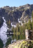
So we begin with the mostly viewless slog to Packwood Lake. A lovely setting, the lake has views up to the north end of the Goat Rocks. One family was camping there and another was doing a day hike.

[BTW these pics supposedly have GPS coordinates embedded in them. I could view them on Google maps to show the whole track, but I couldn't figure out how to post the map here. This was apparently beyond my tech pay grade]


Packwood Lake on Day 1
Image

The bugs were pretty awful from Packwood Lake to Coyote Ridge. But once on the ridge (say 5500 ft) the bugs disappeared.

Here is Coyote Ridge. The flowers were in full effect. The approach to the basin below was unbelievable.
Image

I camped the first night near the intersection of Coyote Ridge and the Saddle Creek Trail (about 1 mile before meeting the PCT). The next morning, the big show awaited. By that I mean, the incredibly dramatic climb over the Goat Rocks and the Cascade crest, crossing the highest point of the Washington PCT.

Intersection of the PCT. Now heading south.
Image

Check out the ridge. I thought for sure I'd hit snow on a steep area and have to turn back. But my luck was running high that day. The trail stayed snow-free, despite snow drops to the left and right. We're at around 7,000 feet here. I see why Backpacking Washington warned to cross this section only in good weather as hikers have died of hypothermia along the route. Lots of signs warning those with pack animals not to pass hikers.

Image

Lots of smells of goats along the way. Here is a goat scratching post right on the PCT as it follows the Cascade crest.

Image

Looking down to the basin before hitting Old Snowy Mountain
Image

The highest point of the PCT in Washington looking at Old Snowy Mountain.
Image

Coming down to the western side of the Goat Rocks was a welcome relief. I was surprised to find more snow over here. But still the trail was easy to follow. I'd say the PCT was about 40% snow-covered, but a boot pack and cairns made it easy-going.

Here is the intersection of the PCT and Snowgrass Trail. Two groups were camping in the area, but lots of empty campsites were available. Here were the first people I saw in 24 hours since leaving Packwood Lake.
Image

After dropping down to Snowgrass Flat (disappointing without flowers, but still only 10% snow), I headed north along the Lily Basin Trail on Day 2. This is where the hiking got hard.

I approached Goat Lake around 4pm, and clouds started to roll in. I was hoping to hike over to the Heart Lake basin for the night, but the weather was deteriorating quickly.
Image

Goat Lake was, well, still quite "snowy."
Image

The hike from Goat Lake over the ridge to the Heart Lake basin was the most challenging of the trip. Deep, steep snow drifts remained. And the low visibility with clouds made the crossing no fun. I decided to leave the "trail" (which was 90% under snow anyway) and head to the trees for the night (good call). Night 2 was spent in a nondescript site somewhere in the Heart Lake Basin.

Day 3 (my hike out day) the weather was clear and visibility excellent. My plan was to hike to the Lily Basin TR and then find a way back to the Packwood TH (my car). It turned out to be a crumby plan.

There was still snow along the Lily Basin Trail, but at least I could see. I was glad to have my Yak Trax for the frozen snow drifts.

Looking down at Heart Lake.
Image

Intersection of the Angry Mountain Trail (the obligatory picture of flowers and Rainier). BTW, the flowers were spectacular along the Lily Basin and Coyote Ridge Trails. I just didn't take many flower pictures, but they were lovely.
Image

Packwood Lake far below on the Lily Basin Trail.
Image

So Backpacking Washington recommends making this a car shuttle. Well, after looking at the map, I thought I could scramble back to my car at the Packwood Lake TH along FS roads and X-country without doing a shuttle. That's what I did for four long hours. It was horrible and I wouldn't wish it on my worst enemy. But I found my car, and home I went (just under three hours to Portland).

I'll be back again to explore this fantastic area.

User avatar
Slugman
Posts: 26
Joined: May 28th, 2008, 10:03 pm
Location: Lynnwood, WA

Re: Goat Rocks Are Open! Packwood Lake to Lily Basin 8/1-3

Post by Slugman » August 4th, 2012, 9:16 pm

Excellent pictures and narrative. I've been to that area several times, and it is spectacular. I've never been up there with that much snow, though, so your pics were a nice change, some places I hardly recognized. Strong work, even if unpleasant, to finish off the loop cross country like that.
Climb the mountains and get their good tidings. Nature's peace will flow into you as sunshine flows into trees. The winds will blow their own freshness into you, and the storms their energy, while cares will drop off like autumn leaves. ~John Muir

skeeter
Posts: 5
Joined: August 13th, 2011, 7:36 pm

Re: Goat Rocks Are Open! Packwood Lake to Lily Basin 8/1-3

Post by skeeter » August 4th, 2012, 9:27 pm

Excellent report on a nice long loop. It's great to see the goat rocks opening up finally, though that shot of Goat Lake looked like it belonged in someone else's TR!

User avatar
Chase
Posts: 1265
Joined: May 28th, 2008, 10:03 pm

Re: Goat Rocks Are Open! Packwood Lake to Lily Basin 8/1-3

Post by Chase » August 5th, 2012, 7:43 am

Great to see Goat Rocks is open in early August. One of my favorite places in the world!

User avatar
roadtripmom
Posts: 304
Joined: March 3rd, 2010, 9:20 pm
Location: Vancouver, WA

Re: Goat Rocks Are Open! Packwood Lake to Lily Basin 8/1-3

Post by roadtripmom » August 5th, 2012, 8:18 am

What a wonderful trip ! Goat rocks is an amazing are and you hit all the best spots. Thank you for sharing. :D
Filling my bucket, one hike at a time.
Amanda

Steve20050
Posts: 395
Joined: November 12th, 2009, 8:06 pm

Re: Goat Rocks Are Open! Packwood Lake to Lily Basin 8/1-3

Post by Steve20050 » August 5th, 2012, 12:18 pm

Great trip report. I can reaffirm it is best to wait for snow melt to hike into this area. Once when much younger I tried this on 4th of July. Spent better part of an afternoon and next day getting up around the snowed in lake in your picture. I ended up scrambling straight down that chute from the lake with my pack. I wanted to get into the meadows below to get out of there instead of going back over the steep snow drifts. Was rather harrowing coming down not being sure it was even possible to do, missing all the cliffs. Yeah, the fun things we do. Glad to hear the trip went well.

User avatar
Born2BBrad
Posts: 1086
Joined: May 1st, 2011, 7:26 pm
Location: The Dalles

Re: Goat Rocks Are Open! Packwood Lake to Lily Basin 8/1-3

Post by Born2BBrad » August 5th, 2012, 1:42 pm

Oh yeah! Now I'm really looking forward to my trip there at the end of August.

Great TR and pics.

Brad
Make now always the most precious time. Now will never come again.
- Jean Luc Picard

Link to GPX tracks
Link to Trip Reports

Darin
Posts: 3
Joined: September 9th, 2011, 9:03 pm

Re: Goat Rocks Are Open! Packwood Lake to Lily Basin 8/1-3

Post by Darin » August 6th, 2012, 12:51 am

Glad to hear it's open. I was just planning this same loop in another 3 weeks - including the scramble from Lily Basin trail to Packwood Lake. Any tips for negotiating that section? what made it so awful? It seems so easy on a map to drop down 1200 feet and hit the lake. Maybe I need a new plan.

User avatar
Bosterson
Posts: 2320
Joined: May 18th, 2009, 3:17 pm
Location: Portland

Re: Goat Rocks Are Open! Packwood Lake to Lily Basin 8/1-3

Post by Bosterson » August 6th, 2012, 7:36 am

Nice work! I did a very similar loop three years ago (except we detoured up from Packwood Lake to Lost Lake and then followed the trail past Chimney Rock to Elk Pass). We made the exact same assumption that you can exit on the Lily Basin trail and then follow the forest roads (with some bushwhacking) back down to the Packwood Lake TH, and we also found it to be a terrible idea - our attempt included endless walking along the roads, a bit of getting lost (following some flagging that led in a circle!), running out of water, etc.

I was less versed in off trail travel then, and we didn't have a GPS and weren't being good about taking compass bearings to guide us down, so I would recommend either following a GPS track or compass bearing when you're heading downhill through the dense forest (the "ridge" isn't as defined as it looks on the map), and maybe cutting off right from the road above Art Lake and off-trailing it down to the basin around Packwood Lake to catch that trail that leads back to the parking lot. We ended up walking down the road north of Art Lake as it switches back and forth, which took foreeeevver.
#pnw #bestlife #bitingflies #favoriteyellowcap #neverdispleased

User avatar
cunningkeith
Posts: 209
Joined: June 26th, 2010, 4:28 am
Location: Portland

Re: Goat Rocks Are Open! Packwood Lake to Lily Basin 8/1-3

Post by cunningkeith » August 6th, 2012, 10:05 am

Bosterson wrote:We made the exact same assumption that you can exit on the Lily Basin trail and then follow the forest roads (with some bushwhacking) back down to the Packwood Lake TH, and we also found it to be a terrible idea - our attempt included endless walking along the roads, a bit of getting lost (following some flagging that led in a circle!), running out of water, etc.
Oh, I forgot about running out of water. I did that too. I had such easy access to water most of the time that I neglected to fill up before leaving the Lily Basin area (before you reach the views of Packwood Lake). I was out of water for a few hours before reaching Art Lake. No fun.
Darin wrote:Any tips for negotiating that section? what made it so awful? It seems so easy on a map to drop down 1200 feet and hit the lake. Maybe I need a new plan.
I did not drop down to Packwood Lake. I dropped down to The Packwood Trailhead. My route went all the way to the Lily Basin TH, then I walked along FS 48 to its end beneath Snyder Moutain. The x-country to FS 4840 (awful x-country like all of this area b/c it has been logged and the overgrowth was dense bushes (thankfully nothing thorny); lots of walking on bushes and branches without being able to see the ground; having to whack branches out of your face the entire time; pace of .5 mile to 1.0 mile per hour.
I did it with GPS, so my line was okay, but it was still slow.

Then from the end of FS 4840, more x-country to FS4820 (I think), then hike along FS 4820 to Art Lake. Then more x-country from Art Lake to the Packwood Lake Trail, then hike out west along the trail for .75 miles.

I did look at the simpler alternative of just dropping down to Packwood Lake from Lily Basin Trail. If I did it again, that's what I'd do. Although I think it involves more total mileage of x-country, the big advantage (which I hadn't considered) is you're in wilderness area, so in theory the forest should be more mature and easier to scramble through. If you try that route, let us know how it goes.

Post Reply