Table Mtn: A Small Variation 21-April-2012

This forum is used to share your experiences out on the trails.
User avatar
VanMarmot
Posts: 1924
Joined: May 28th, 2008, 10:03 pm
Contact:

Table Mtn: A Small Variation 21-April-2012

Post by VanMarmot » April 22nd, 2012, 6:37 am

Table Mtn is very familiar territory but it is on the "sunny" side of the Gorge and thus seemed ideal for what was promised as (and proved to be) a seriously bluebird day. After parking at the Bonneville Hot Springs "TH", I headed up the Dick Thomas Trail. Someone (thank you!) has finally chainsawed the two trees that required "duck and cover" moves shortly after the start of the trail - it was a new experience walking upright through that stretch. I took the road and by-pass trail up to the PCT, encountering my first salamander of the season.

Image

I was aiming for Table's NW Ridge, so I stayed on the PCT heading north. Coming around the corner of Table's West Ridge, S Birkenfeld (Pt 3553) came into view, so it got added to the hike.

Image

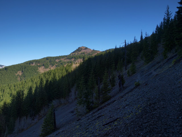
The PCT was snowfree until just before and after its crossing under the power lines - here there were stretches of firm, walkable snow.

Image

I stayed on the PCT as it climbed up and around the lower slopes of S Birkenfeld, for a good view of Adams,

Image

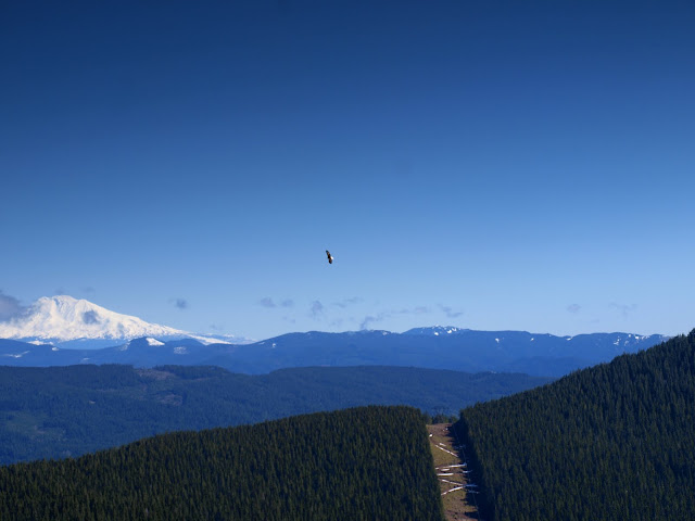
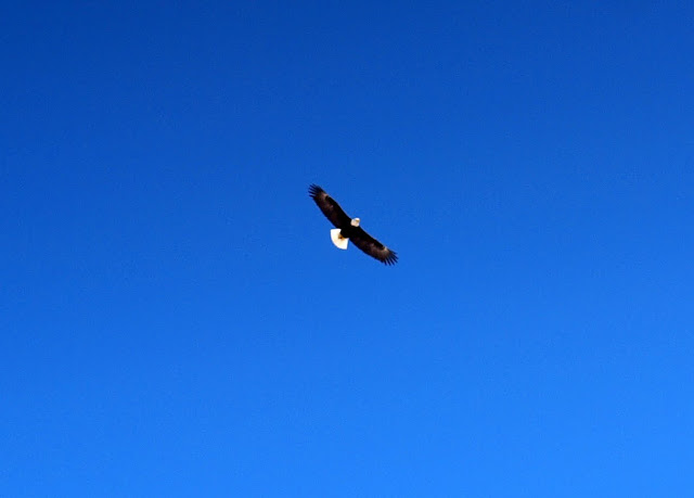
and of a bald eagle circling overhead.

Image

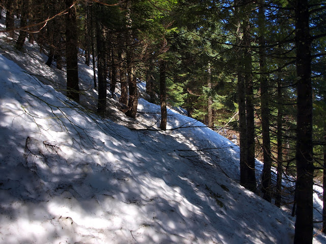
At this point, instead of heading up the ridge (largely snowfree), I decided to continue on the PCT. This was a poor choice as far as speedy travel was concerned, as the PCT here is still covered by several feet of steeply angled, alternately soft and slippery snow. It was slow going.

Image

After reaching the saddle between S Birkenfeld and Birkenfeld (Pt 3763), I thought about going over to Birkenfeld (to the left, with Rainier in the distance).

Image

But that route was all on snow, which had now softened considerably - making it a slow slog without snow shoes. So I headed back across the top of S Birkenfeld (largely snow-free and much easier travel compared to the PCT on the slopes below) to a lunch spot with a view of Table and Hood.

Image

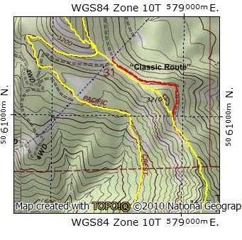
From there, my plan was to climb Table via its NW ridge, but I wasn't relishing post-holing through the snow and brush on the old road to the E of the ridge. But from my lunch perch, it looked like there might be a route up the ridge itself, by-passing the road and much of the snow. From where the power line service road crosses the saddle, the "classic" route up Table's NW ridge goes E on the old road. But there's a more obscure, much more faded "road" that goes to the right. I followed this and soon encountered a use trail that took me along the top of the ridge. There were a few brushy spots but not many and progress was rapid. From a distance, it looks like you might encounter a wildly exposed traverse just W of Pt 3210, but you don't. I soon reached the point on the ridge just before where the old road and the use trail to the summit converge. Finding this route going down the ridge could be trickier but certainly doable.

Image

There were patches of snow on the ridge from here to the summit but nothing serious. From the ridge, I had a view of a contrail sweeping past Table Mtn.

Image

One person passed me right after Carpenters Lake and I passed another person on the ridge. There were two people on the summit as I was climbing the ridge but they were gone when I finally topped out. It seemed odd to have the summit of Table to myself on such a nice day. But then marmots aren't particularly sociable... Views all around, of course. Silver Star (S) and Three Corner Rock (T),

Image

then Three Corner Rock (T), S Birkenfeld (SB), Birkenfeld (B), and St. Helens (H).

Image

I passed 6 people while descending Heartbreak Ridge (... that boulder field :evil: ) and saw a group across on the West Ridge. My favorite view on this route is the towering E face of Table.

Image

Six more people on the road toward Aldrich Butte TH and that was the "crowd" for the day. Should probably have pushed on to Birkenfeld but finding that way around the road on the ridge made up for not doing so. Not a particularly long day (12.4 mi, 4100' EG) but extra aerobic thanks to the snow, route finding, and twists and turns along the ridge.

Image
Last edited by VanMarmot on April 24th, 2012, 7:35 pm, edited 3 times in total.

User avatar
Peder
Posts: 3401
Joined: May 28th, 2008, 10:02 pm
Location: Lake Oswego

Re: Table Mtn: A Small Variation 21-April-2012

Post by Peder » April 22nd, 2012, 9:15 am

Bruce - Thanks for the report; it seems that the snow is melting rapidly. :) I will check out the variation on the Table north ridge. As always you take great pictures, I love your bald eagle.
Some people are really fit at eighty; thankfully I still have many years to get into shape…

User avatar
Don Nelsen
Posts: 4380
Joined: May 28th, 2008, 10:03 pm
Location: Vancouver, WA

Re: Table Mtn: A Small Variation 21-April-2012

Post by Don Nelsen » April 22nd, 2012, 5:11 pm

Excellent report and especially the photos! I've wondered if that variation was do-able but never gave it a shot, so, thanks for documenting that. I'll give it a try the next time I'm on Table.

-Don
"Everything works in the planning stage" - Kelly

"If you don't do it this year, you will be one year older when you do" - Warren Miller

T-money
Posts: 1
Joined: March 25th, 2012, 3:09 pm

Re: Table Mtn: A Small Variation 21-April-2012

Post by T-money » April 23rd, 2012, 3:15 am

I think I passed you Saturday morning right after Carpenters Lake. Where you wearing blue gators? I went up the West Trail and came down Heartbreak Ridge. Your route sounded much more interesting the mine. The weather was amazing!!

User avatar
Crusak
Posts: 3617
Joined: August 6th, 2009, 7:33 pm
Location: Oregon

Re: Table Mtn: A Small Variation 21-April-2012

Post by Crusak » April 23rd, 2012, 5:16 am

First of all, thanks for bringing your bluebird hiking days to the weekends! :) Your schedule change is working out well for us all.

Great pictures, especially of the bald eagle. Very nice.
Jim's Hikes

Solvitur Ambulando

User avatar
VanMarmot
Posts: 1924
Joined: May 28th, 2008, 10:03 pm
Contact:

Re: Table Mtn: A Small Variation 21-April-2012

Post by VanMarmot » April 23rd, 2012, 8:17 am

T-money wrote:I think I passed you Saturday morning right after Carpenters Lake. Where you wearing blue gators? I went up the West Trail and came down Heartbreak Ridge. Your route sounded much more interesting the mine. The weather was amazing!!
Yep, that was me with the blue gaiters. You were moving right along and stayed on the road, while I cut right where the road crosses the ridge and took the use trail up the ridge to the PCT. Weather was great! :D

User avatar
pdxflowergirl
Posts: 589
Joined: March 6th, 2009, 12:47 pm
Location: Portland, Oregon
Contact:

Re: Table Mtn: A Small Variation 21-April-2012

Post by pdxflowergirl » April 23rd, 2012, 8:45 am

Crusak wrote:First of all, thanks for bringing your bluebird hiking days to the weekends! Your schedule change is working out well for us all.

Great pictures, especially of the bald eagle. Very nice.
I agree! This trend of having beautiful weather on the weekends has been awesome. And the bald eagle photo is wonderful.

We hiked to the summit via the "classic" route on Sunday (4/22/12). The weather was glorious! Instead of submitting another TR, I'm going to post a few pics here. Snow seems to be melting quickly with only a few sparse patches to hike through on the north side. The descent described as "arduous" in the field guide should be dubbed "ankle-break" ridge :lol: Definitely prefer the ascent up "heart-break" ridge. After all the full sun exposure, I appreciated returning to the shade of the forest (and Walking Man Brewery). Nice to see so many reports on this hike!

NE vista (bad example of image stitched together in Pano app on my iPhone)
ne_view.jpg
SW vista (good example of image stitched together in Pano app on my iPhone)
sw_view.jpg
talus slope
talus slope.jpg
eye on the goal
summit.jpg
sunset on the Columbia
sunset.jpg
Kam

User avatar
Jack
Posts: 325
Joined: November 22nd, 2011, 3:36 pm

Re: Table Mtn: A Small Variation 21-April-2012

Post by Jack » April 23rd, 2012, 9:51 am

VanMarmot, those are some sweet pics and a fine trip report. Very interesting about the road on the west side from the powerlines. We, coincidentally, did the same route in reverse, Sun., with a few variations I’ll list later in a TR. I’ve always thought that road on the west was just a dead end to nowhere. Thanks for scouting out a possible alternative. We came down the eastside road, which as expected was full of snow and half buried deciduous branches. With that, we then went over and back via the top of S. Belkenfeld, due to the ankle flopping drifts we knew seem to hang around forever on the eastside PCT, every year. Just getting through there is commendable, indeed! Thanks for the great report and spectacular photos!

User avatar
potato
Posts: 1211
Joined: October 10th, 2011, 9:16 pm
Location: my car
Contact:

Re: Table Mtn: A Small Variation 21-April-2012

Post by potato » April 23rd, 2012, 5:28 pm

Thanks for the TR, and for bringing the nice weather to the weekends like Crusak said :)

pdxflowergirl, I did the same hike yesterday. probably saw some of the same people, if not each other... did you see the 3-legged dog?
self observing universe (main blog)
Joe hikes (PCT blog)
Laws of Nature (bandcamp)

User avatar
pdxflowergirl
Posts: 589
Joined: March 6th, 2009, 12:47 pm
Location: Portland, Oregon
Contact:

Re: Table Mtn: A Small Variation 21-April-2012

Post by pdxflowergirl » April 23rd, 2012, 8:51 pm

theradpotato wrote:I did the same hike yesterday. probably saw some of the same people, if not each other... did you see the 3-legged dog?
Yes! We were the group of six (3 women, 3 men) taking an extended lunch break at the overlook. I asked about your dog and you told me the rescue group amputated it and then she came home with you with instructions to keep her on "bed rest." I am curious how she fared on the return trip. That section with the cairns was grueling.

Also, did your dogs pick up any ticks?
Kam

Post Reply