Trail/Road Closures, Gnarl Ridge Fire

General discussions on hiking in Oregon and the Pacific Northwest
User avatar
Grannyhiker
Posts: 4598
Joined: May 28th, 2008, 10:03 pm
Location: Gateway to the Columbia Gorge

Gnarl Ridge Fire - September Redux - Updates and Closures

Post by Grannyhiker » September 18th, 2008, 5:06 pm

I know this has been posted in the Trip Reports forum, but since it could affect a lot of weekend hiking plans, I decided to post it here, too.

From the Hood River Ranger District, Mt. Hood National Forest, as of today (9/18):
http://www.fs.fed.us/r6/mthood/conditions/index.shtml
EMERGENCY FIRE CLOSURE
GNARL FIRE UPDATE: THE FOLLOWING CAMPGROUNDS TRAILS AND ROADS ARE CLOSED DO TO ACTIVITY FROM THE GNARL RIDGE FIRE: Bluegrass Ridge Trail #647, Cloud Cap RD #3512, Cloud Cap Campground, Cooper Spur Trail #600-B, East Fork Trail #650, Elk Cove Trail #631, Elk Meadows Trail #645 north of the intersection with the Newton Creek Trail #646, Elk Meadows Perimeter Trail #645-A, Forest Road #2840 and associated spurs (Laurance Lake RD), Forest Road #3511 and associated spurs, Forest Road #3520 and associated spurs, Gnarl Ridge Trail #652, Kinnickinnick campground (Laurance Lake), Lamberson Spur Trail #644, Little John Snopark, Mazama Trail #625 (a.k.a.: Cathedral Ridge Trail), Pnnacle Ridge #639, Polallie Ridge #643,Tamanawas Falls Trail #650-A, Tamanawas Tie Trail #650-B, Tilly Jane campground, Tilly Jane Trail #448, Tilly Jane Trail #643, Tilly Jane Trail #600-A, Timberline Trail #600 from the intersection with the Newton Creek Trail #646 north and west to intersection with the McGee Creek Trail #627, Vista Ridge Trail #626, Wagon Road #642.
Evidently the Cloud Cap Inn has been spared, but due to heavy smoke the status of the Tilly Jane cabins is still unknown. http://www.inciweb.org/incident/news/article/1465/8221/ The fire did burn through the Tilly Jane campground.

User avatar
Splintercat
Posts: 8334
Joined: May 28th, 2008, 10:03 pm
Location: Portland
Contact:

Re: Red Flag Warning - Gnarl fire back to life? 9-16-08

Post by Splintercat » September 18th, 2008, 5:13 pm

Wow - I was just looking at the USFS kml for the fire perimeter, and the boundary for the "heat perimeter" not only jumps Polallie Canyon, but extends across the Cloud Cap slopes all the way to the far lip of the Eliot Branch canyon...! Yikes! I don't know exactly that that means, but it doesn't bode well for structures in the historic Cloud Cap triangle.

Tom :shock:

User avatar
Splintercat
Posts: 8334
Joined: May 28th, 2008, 10:03 pm
Location: Portland
Contact:

Re: Trail/Road Closures, Gnarl Ridge Fire

Post by Splintercat » September 18th, 2008, 5:21 pm

Folks, I just merged three different threads to make this a bit easier to navigate, since this is a pretty big deal!

Tom

User avatar
retired jerry
Posts: 14424
Joined: May 28th, 2008, 10:03 pm

Re: Trail/Road Closures, Gnarl Ridge Fire

Post by retired jerry » September 18th, 2008, 7:20 pm

Looking at your link to trail closures, all the North side trails are closed, bummer - the Elk Cove, Pinnacle Ridge, McGee Creek, PCT from Lolo Pass to Top Spur, etc.

The TV news said Cloud Cap structure was safe.

User avatar
Splintercat
Posts: 8334
Joined: May 28th, 2008, 10:03 pm
Location: Portland
Contact:

Re: Trail/Road Closures, Gnarl Ridge Fire

Post by Splintercat » September 18th, 2008, 8:27 pm

This is somewhat old, but is the latest from the InciWeb site:

"The 2375-acre fire has burned around the historic Cloud Cap Inn, but retardant drops helped keep the inn from burning. Tilly Jane campground has been burned over but, due to heavy smoke, the status of the historic Tilly Jane cabins is unknown."

:shock:

Wyeast pal
Posts: 72
Joined: May 28th, 2008, 10:03 pm

Re: Trail/Road Closures, Gnarl Ridge Fire

Post by Wyeast pal » September 18th, 2008, 8:47 pm

Here is the link to the google map of the estimated fire perimeter. All the cloud cap road switchbacks are within the estimated perimeter.
http://www.inciweb.org/incident/1465/ then go to the lower right corner for the current map link.

Wyeast pal
Posts: 72
Joined: May 28th, 2008, 10:03 pm

Re: Trail/Road Closures, Gnarl Ridge Fire

Post by Wyeast pal » September 18th, 2008, 8:50 pm

and, photos - the Hood River News http://www.hoodrivernews.com/ has some good aerial shots with a couple showing Cooper Spur ski runs so you can get a better orientation.

User avatar
adamschneider
Posts: 3717
Joined: May 28th, 2008, 10:02 pm
Location: SE Portland
Contact:

Re: Trail/Road Closures, Gnarl Ridge Fire

Post by adamschneider » September 18th, 2008, 9:21 pm

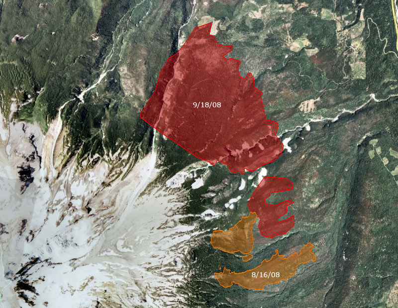
Holy cow: :shock:

Image

User avatar
Splintercat
Posts: 8334
Joined: May 28th, 2008, 10:03 pm
Location: Portland
Contact:

Re: Trail/Road Closures, Gnarl Ridge Fire

Post by Splintercat » September 18th, 2008, 10:00 pm

Boy, that's a lot of terrain! What strikes me as odd is how the fire has hugged timberline, and rotated around the mountain, as opposed to sending runners downslope through all that standing bug damage that you can see in the orthophotos.

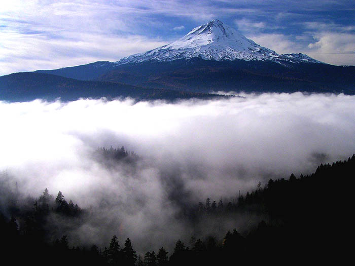
Must just be unusual wind currents -- and the meteorologists have also referenced a pillow of warm air that has collected in the East Fork Valley. I've seen that effect, too. If you've been up above the East Fork in winter, you've likely seen fog backing up from the Hood River Valley:

Image

So, there must be a similar effect with hot air rising from the valley and getting trapped in the upper East Fork Valley? Weird.

WyEast Pal, do you know if the "trail restoration" that was mentioned when the first phase of the fire was winding down referred to the Lamberson Spur trail? I'm wondering if that unfinished route might have taken a permanent blow with the fire... or whether it might be the other way around - that the fire saved the trail?

Tom

Luv2Kayak
Posts: 74
Joined: May 28th, 2008, 10:03 pm

Re: Trail/Road Closures, Gnarl Ridge Fire

Post by Luv2Kayak » September 18th, 2008, 10:13 pm

What could be good news, according to Dave Waag, by way of Darryl Lloyd:

http://offpistemag.com/

A short update as of about 3pm Thursday: The latest report shows that Cloud Cap and the Snowshoe cabin are still ok. Also, a visual on the Tilly Jane area allowed views of the tree canopy around Tilly Jane and it too was intact. Although no direct visual on the A-frame or guard station was confirmed, the existence of the canopy is a good sign that it could be ok.

Post Reply