From the Hood River Ranger District, Mt. Hood National Forest, as of today (9/18):
http://www.fs.fed.us/r6/mthood/conditions/index.shtml
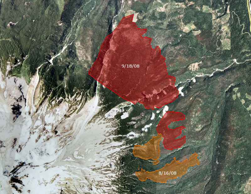
Evidently the Cloud Cap Inn has been spared, but due to heavy smoke the status of the Tilly Jane cabins is still unknown. http://www.inciweb.org/incident/news/article/1465/8221/ The fire did burn through the Tilly Jane campground.EMERGENCY FIRE CLOSURE
GNARL FIRE UPDATE: THE FOLLOWING CAMPGROUNDS TRAILS AND ROADS ARE CLOSED DO TO ACTIVITY FROM THE GNARL RIDGE FIRE: Bluegrass Ridge Trail #647, Cloud Cap RD #3512, Cloud Cap Campground, Cooper Spur Trail #600-B, East Fork Trail #650, Elk Cove Trail #631, Elk Meadows Trail #645 north of the intersection with the Newton Creek Trail #646, Elk Meadows Perimeter Trail #645-A, Forest Road #2840 and associated spurs (Laurance Lake RD), Forest Road #3511 and associated spurs, Forest Road #3520 and associated spurs, Gnarl Ridge Trail #652, Kinnickinnick campground (Laurance Lake), Lamberson Spur Trail #644, Little John Snopark, Mazama Trail #625 (a.k.a.: Cathedral Ridge Trail), Pnnacle Ridge #639, Polallie Ridge #643,Tamanawas Falls Trail #650-A, Tamanawas Tie Trail #650-B, Tilly Jane campground, Tilly Jane Trail #448, Tilly Jane Trail #643, Tilly Jane Trail #600-A, Timberline Trail #600 from the intersection with the Newton Creek Trail #646 north and west to intersection with the McGee Creek Trail #627, Vista Ridge Trail #626, Wagon Road #642.