I don't know how far up they made it, but TKO cleared out brush and logs from the South Burnt Lake Trail last week, so now is the time to go while the way is clear! Barring extreme heat or smoky skies I'm hoping to head up there when I have an unscheduled free day in a few weeks, and I'll report back if no one else has.
If you didn't see it, last summer Chip Down reported that thanks to logging operations that required road improvements, the rough section of Road 207 to the trailhead is now shorter than it used to be.
Brush and logs cleared from South Burnt Lake Trail
-
justpeachy
- Posts: 3068
- Joined: May 28th, 2008, 10:03 pm
- Location: Portland, OR
- Contact:
-
justpeachy
- Posts: 3068
- Joined: May 28th, 2008, 10:03 pm
- Location: Portland, OR
- Contact:
Re: Brush and logs cleared from South Burnt Lake Trail
We hiked from the South Burnt Lake Trailhead yesterday, August 28. Road 207 passes through a piece of private property and by the looks of it the entire piece was clearcut:


From the point where you turn off the highway it's about three miles of decent road. 0.6 miles of pavement on Road 27, followed by gravel on Road 207. I wouldn't call it great but based on what I've heard it sounds like this is better than before. (Yesterday was my first time driving it so I can't compare to prior experience.) After about three miles you reach the far edge of the clearcut and the road stops being decent and becomes rough with rocks and potholes.
The giant puddle just before the switchback has dried up. I guess that's one benefit of going 60 days without rain, or however long it's been now:

After the switchback the road is mostly just rocky, but there are some potholes too. You don't need 4WD, but high clearance is a plus and I was very grateful for the BFG KO2 tires on our Outback.
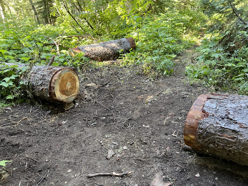
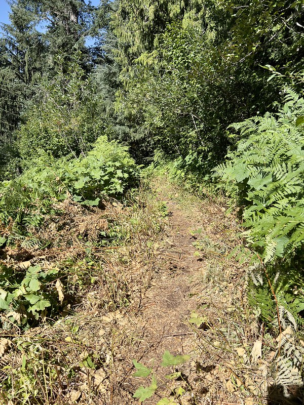
As for the trail, the Burnt lake Trail is mostly brush-free up to the junction with the Devils Tie Trail, except for a few short sections. The logs have been cleared as well. Thanks for clearing this TKO!
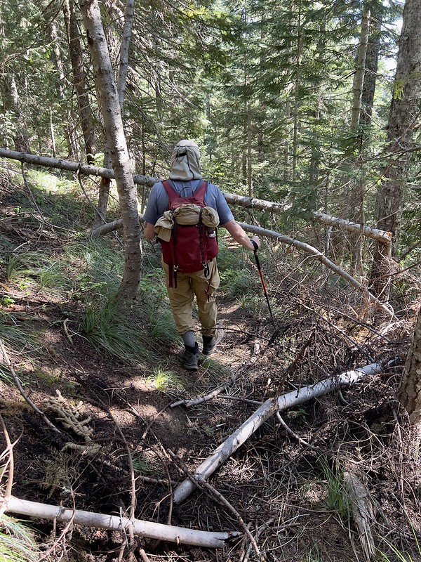
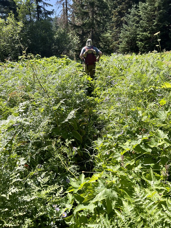
The Devils Tie Trail was pretty good and so was the Cast Lake Trail and the Zigzag Mountain Trail. However, descending back to the trailhead on the Burnt Lake Trail was where the worst section was. The crew didn't make it up this far and that first mile south of the junction with the Zigzag Mountain Trail has not been cleared. It has about 20 fallen trees and plenty of brush:

After a mile though it got better and then it was smooth sailing back to the trailhead. BTW I had the old 1980 USGS quad loaded in Avenza on my phone, so on the drive out we used it to figure out where the abandoned Devils Canyon Trail was located. It's hard to tell from this picture but it was actually quite easy to spot on the side of the road. Looks like it still gets used. Hunters maybe?

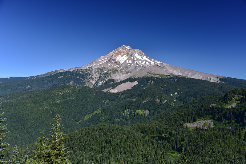
I'll leave you with a shot of Mt. Hood from the Zigzag Mountain Trail. One of the finest views of Mt. Hood, in my opinion.
From the point where you turn off the highway it's about three miles of decent road. 0.6 miles of pavement on Road 27, followed by gravel on Road 207. I wouldn't call it great but based on what I've heard it sounds like this is better than before. (Yesterday was my first time driving it so I can't compare to prior experience.) After about three miles you reach the far edge of the clearcut and the road stops being decent and becomes rough with rocks and potholes.
The giant puddle just before the switchback has dried up. I guess that's one benefit of going 60 days without rain, or however long it's been now:
After the switchback the road is mostly just rocky, but there are some potholes too. You don't need 4WD, but high clearance is a plus and I was very grateful for the BFG KO2 tires on our Outback.
As for the trail, the Burnt lake Trail is mostly brush-free up to the junction with the Devils Tie Trail, except for a few short sections. The logs have been cleared as well. Thanks for clearing this TKO!
The Devils Tie Trail was pretty good and so was the Cast Lake Trail and the Zigzag Mountain Trail. However, descending back to the trailhead on the Burnt Lake Trail was where the worst section was. The crew didn't make it up this far and that first mile south of the junction with the Zigzag Mountain Trail has not been cleared. It has about 20 fallen trees and plenty of brush:
After a mile though it got better and then it was smooth sailing back to the trailhead. BTW I had the old 1980 USGS quad loaded in Avenza on my phone, so on the drive out we used it to figure out where the abandoned Devils Canyon Trail was located. It's hard to tell from this picture but it was actually quite easy to spot on the side of the road. Looks like it still gets used. Hunters maybe?
I'll leave you with a shot of Mt. Hood from the Zigzag Mountain Trail. One of the finest views of Mt. Hood, in my opinion.
-
oldandslow

- Posts: 175
- Joined: August 22nd, 2012, 12:47 pm
Re: Brush and logs cleared from South Burnt Lake Trail
Agree. A fine view of Mt. Hood.
About 20 years ago on my last backpacking trip we spent two night on top of Horseshoe Ridge just off the Zigzag Mountain trail. I took these pictures with my brand new Olympus point and shoot digital camera.