What in the hay now?

General discussions on hiking in Oregon and the Pacific Northwest
User avatar
kaltbluter
Posts: 397
Joined: June 2nd, 2014, 10:36 am

Re: What in the hay now?

Post by kaltbluter » February 9th, 2016, 1:33 pm

Webfoot wrote:Have you read The Machine Stops?
Not for many years. But I recall that the government banned hiking.
The Machine Stops wrote:Advanced thinkers, like Vashti, had always held it foolish to visit the surface of the earth. Air-ships might be necessary, but what was the good of going out for mere curiosity and crawling along for a mile or two in a terrestrial motor? The habit was vulgar and perhaps faintly improper: it was unproductive of ideas, and had no connection with the habits that really mattered.
...
Those who still wanted to know what the earth was like had after all only to listen to some gramophone, or to look into some cinematophote.

User avatar
retired jerry
Posts: 14418
Joined: May 28th, 2008, 10:03 pm

Re: What in the hay now?

Post by retired jerry » February 9th, 2016, 1:43 pm

ha, ha,... yeah, good one - I scanned it

one possible dystopian future

I'm sure other scifi writers have explored the same theme, although I can't think of any

User avatar
BurnsideBob
Posts: 538
Joined: May 6th, 2014, 3:15 pm
Location: Mount Angel, Oregon

Re: What in the hay now?

Post by BurnsideBob » February 9th, 2016, 11:39 pm

Koda wrote:
BurnsideBob wrote:
Koda wrote:doesnt matter, it still uploads when you turn it back on...
My understanding is that your phone transmits location when pinged by cell phone towers, even in 'power off' mode. The only way to stop this transmission is to remove the battery.
Ive done a few off trail trips well out of cell reception and cell towers and pings etc. Used my phone in airplane mode to use Backcountry Navigator.
later on I signed onto Google and checked out that weekend and the entire track was there, and fairly accurate. All off trail, all off the grid. I didnt upload it. If I want to I can still view it and I think I can even download it....

this is why I think that as long as you allow location services, your Android pbone is caching your location at all times regardless of cell reception or if your using airplane mode, and then uploads it automatically when you get back in town..
Koda, you are right. We aren't talking about the same process, and I confused the two, for which I apologize.

What I'm talking about is your cell phone's automatic response to an external ping even if turned off--you have to remove the battery to stop that response. What you are talking about is based on data generated by sensors internal to your phone--accelerometers, compass, gps circuitry, barometer as applicable.
I keep making protein shakes but they always turn out like margaritas.

User avatar
kaltbluter
Posts: 397
Joined: June 2nd, 2014, 10:36 am

Re: What in the hay now?

Post by kaltbluter » March 22nd, 2016, 9:14 am

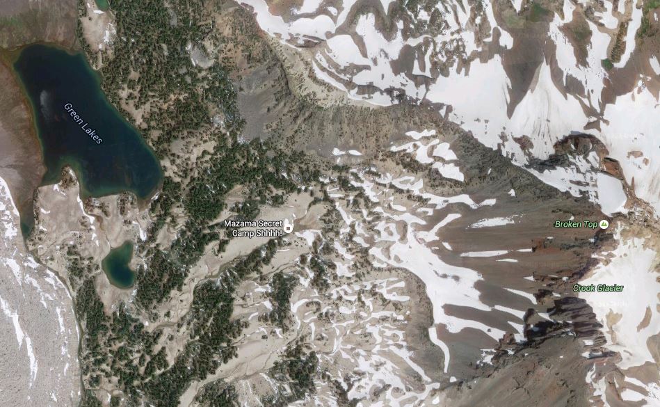
Bosterson wrote:Is this a new thing on Google Maps? Jesus...
Image
I noticed this when I was checking out a gpx track from last summer. Shhh! Don't tell.
Image

User avatar
VanMarmot
Posts: 1924
Joined: May 28th, 2008, 10:03 pm
Contact:

Re: What in the hay now?

Post by VanMarmot » March 22nd, 2016, 9:19 am

kaltbluter wrote:
Bosterson wrote:Is this a new thing on Google Maps? Jesus...
Image
I noticed this when I was checking out a gpx track from last summer. Shhh! Don't tell.
Image
I actually camped there once years ago on a Mazama climb of Broken Top - but nobody was calling it a "secret camp" - it was just a place off the trail to camp. But who puts made-up stuff like this on these maps anyway??? There seems to be a growing disconnect between map software gurus and folks who actually go hiking & camping???

User avatar
kepPNW
Posts: 6411
Joined: June 21st, 2012, 9:55 am
Location: Salmon Creek

Re: What in the hay now?

Post by kepPNW » March 22nd, 2016, 11:30 am

VanMarmot wrote:But who puts made-up stuff like this on these maps anyway??? There seems to be a growing disconnect between map software gurus and folks who actually go hiking & camping???
Not sure there ever was a "connect" to speak of. But Google seems to have disabled the creation of new places. Perhaps for this very reason?
Karl
Back on the trail, again...

User avatar
VanMarmot
Posts: 1924
Joined: May 28th, 2008, 10:03 pm
Contact:

Re: What in the hay now?

Post by VanMarmot » March 23rd, 2016, 8:03 am

kepPNW wrote:
VanMarmot wrote:But who puts made-up stuff like this on these maps anyway??? There seems to be a growing disconnect between map software gurus and folks who actually go hiking & camping???
Not sure there ever was a "connect" to speak of. But Google seems to have disabled the creation of new places. Perhaps for this very reason?
Sad. I was looking forward to the YouTube video of the drone flight over the secret Mazama camp site...

User avatar
potato
Posts: 1211
Joined: October 10th, 2011, 9:16 pm
Location: my car
Contact:

Re: What in the hay now?

Post by potato » March 23rd, 2016, 10:00 am

I guess I will be the lone person to say "I don't see how this is a big deal at all."

Like Karl was saying, data wants to be free... there is a lot of data to be found if you look. That's life now. I don't feel like the internet is crawling with people who are looking for a hint of new destinations hidden in the gorge that they can go just to invade your privacy and cause problems for SAR. And I doubt many people would rely on google maps as their only source of info on this hike, they will probably google Rock of Ages based on seeing the name and find out more info. Even if they do go there unprepared on a whim, it's their job to have personal responsibility and turn around if they realize the trail is tougher than they expected. To me it feels kind of elitist to assume that the masses are so dumb that they will put themselves in danger just because they saw something on google maps. The gorge is very close to Portland and if you're looking for solitude it might not be the best place to go. Any solitude experienced there should be seen as kind of miraculous. I think it would be silly to ask Google to limit this kind of data, it's definitely not their vision to limit access to data based on the fear that the person who sees the data will not be smart enough to use it well.

I agree it would be helpful to show that the trail is unofficial/unmaintained by making it look different on the map, though.
self observing universe (main blog)
Joe hikes (PCT blog)
Laws of Nature (bandcamp)

User avatar
Bosterson
Posts: 2317
Joined: May 18th, 2009, 3:17 pm
Location: Portland

Re: What in the hay now?

Post by Bosterson » March 23rd, 2016, 11:04 am

potato wrote:I don't feel like the internet is crawling with people who are looking for a hint of new destinations hidden in the gorge...
I suspect you're wrong about this. Again, see the #munrapoint hashtag. The internet is definitely contributing to the popularity of these previously little used areas.

Frankly, and no offense to Lurch because I know it's his job to care about this kind of thing, for the sake of argument I don't especially care if every single "novice" person who wanders up the ROA trail were to accidentally walk off the cliff up there. I agree with you that it's not necessarily society's job to protect people from themselves, and that inexperienced people are generally not actually as stupid (in terms of potentially harming themselves) as one might expect. Even though plenty of people will indeed get lost or hurt or need rescue, the proportion of these people out of the seething masses that will go up there is quite small.

However, the seething masses are the problem. New user trails being cut all over the hillside are the problem.

Image

If it's "elitist" to conclude that the seething masses are (overall) either ignorant or negligent when it comes to their impact on the environment, then so be it, but this is why trails exist in the first place. You simply cannot have that many people using an area without serious impact unless they're all funneled into a very specific path. Maybe not every single one of the novices going to ROA is tromping ferns left and right, but even if the proportion who does is small, the amount of damage the environment can absorb is finite, not proportional. The ferns can take a small proportion of a limited group tromping around (eg, when some of us go off trail), but they can't take a "small" proportion when it's of a skyrocketing number. And most of the new people going up to the arch are "tourist" types running up from their car to check out the arch and then go back down, not hikers who at least theoretically have some exposure to Leave No Trace. I think noting that an increase in environmental damage correlates to an increase in an area's popularity is less about "elitism" and more about empiricism.

Imagine if the Multnomah Falls trail weren't paved - or weren't even a trail at all. Do you think the hillside could take thousands - let alone millions - of people walking over it?
#pnw #bestlife #bitingflies #favoriteyellowcap #neverdispleased

User avatar
kepPNW
Posts: 6411
Joined: June 21st, 2012, 9:55 am
Location: Salmon Creek

Re: What in the hay now?

Post by kepPNW » March 23rd, 2016, 11:21 am

potato wrote:I guess I will be the lone person to say "I don't see how this is a big deal at all."

Like Karl was saying, data wants to be free... there is a lot of data to be found if you look. That's life now.
Yep, same conclusion here, which I was attempting to coax out from others with that observation. :)
potato wrote:I doubt many people would rely on google maps as their only source of info on this hike, they will probably google Rock of Ages based on seeing the name and find out more info.
Tried it. Just googling the feature name brings up all sorts of unrelated things. Adding "hike" to the google brings up... any guesses...? Why, of course! Our very own Field Guide! First on the list:
Third on the list, a gushing article from Backpacker magazine, with the Instagram-grabbing subtitle...
  • Backpacker magazine wrote:Trek through a lush wonderland en route to four spectacular waterfalls, countless swimming holes, and postcard-worthy views of the Columbia River Gorge on this 8.8-mile loop.
And everyone's favorite Big-O writer, Terry Richard, has the #4 slot occupied with a thriller description next. He correctly notes the route was (first?) published by the Lowes in the 1970s.

The story's out, folks. No way to reel that puppy back in at this point. That's the slippery nature of data.
Bosterson wrote:However, the seething masses are the problem. New user trails being cut all over the hillside are the problem.
No rational dispute there. The erosion can be significant. But we all know that "hikers will find a way." (How many are going to avoid going to Tunnel Falls simply because they have to step over a "closed" creek? :lol:) I'll continue to suggest that attempting to suppress information about it will be as effective as pounding sand.
Bosterson wrote:I think noting that an increase in environmental damage correlates to an increase in an area's popularity is less about "elitism" and more about empiricism.
It's probably not the act of noticing that's drawing the "elitism" tag into the conversation. ;)
Karl
Back on the trail, again...

Post Reply