What in the hay now?

Re: What in the hay now?
Having a forum only viewable by registered members, or registered members with a couple posts, is doable with the software.
-Dan
Site Tech Helper
Site Tech Helper
Re: What in the hay now?
Should also be able to keep the crawlers from indexing certain boards

Re: What in the hay now?
I think asking folks to register (without also having to post) is not too much of an imposition, if doing so would stop/slow the crawlers and bots. I think doing something like this would be particularly helpful if it kept automotons from ripping data out of the context of a TR - thus losing all interpretation and insight that the TR provided. As I said before, several commercial trail sites uncritically upload data on trails that never existed, or are now abandoned, or haven't received maintenance in years, or are use trails, etc. I don't think Oregon Hikers should feed this fraudulence if it can avoid doing so.
-
retired jerry

- Posts: 14418
- Joined: May 28th, 2008, 10:03 pm
Re: What in the hay now?
the bots examine content including links to other sites and use that to prioritize search engine results
we wouldn't want to exclude them, except maybe the forum of off trail reports that we wouldn't want to show up in search results anyway
we wouldn't want to exclude them, except maybe the forum of off trail reports that we wouldn't want to show up in search results anyway
Re: What in the hay now?
Bot access and permissions to individual boards is manageableretired jerry wrote:the bots examine content including links to other sites and use that to prioritize search engine results
we wouldn't want to exclude them, except maybe the forum of off trail reports that we wouldn't want to show up in search results anyway
-
derwoodynck

- Posts: 286
- Joined: April 21st, 2013, 2:26 pm
- Contact:
Re: What in the hay now?
One of the things that I have noticed is that some of the items showing up on Google are misplaced by quite a bit. A perfect example is Shelter Falls along South Fork Wychus Creek in the Three Sisters Wilderness. Today was the first day I've noticed it showing up on the map and it is much too far upstream. I can't imagine anyone relying solely on Google maps to find places like this, but if they did they would be way off. If you look at in on the Northwest Waterfall Survey Map you can see just how far off it is.
The tree icon to the far left is where Google is showing Shelter Falls while it's actual location is shown by the icon on the upper right hand side.
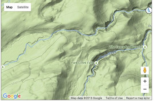
Here is the link to the Northwest Waterfall Survey page.
http://www.waterfallsnorthwest.com/nws/ ... p?num=3701
The tree icon to the far left is where Google is showing Shelter Falls while it's actual location is shown by the icon on the upper right hand side.
Here is the link to the Northwest Waterfall Survey page.
http://www.waterfallsnorthwest.com/nws/ ... p?num=3701

Re: What in the hay now?
derwoodynck wrote:One of the things that I have noticed is that some of the items showing up on Google are misplaced by quite a bit. A perfect example is Shelter Falls along South Fork Wychus Creek in the Three Sisters Wilderness. Today was the first day I've noticed it showing up on the map and it is much too far upstream. I can't imagine anyone relying solely on Google maps to find places like this, but if they did they would be way off. If you look at in on the Northwest Waterfall Survey Map you can see just how far off it is.
The tree icon to the far left is where Google is showing Shelter Falls while it's actual location is shown by the icon on the upper right hand side.
Here is the link to the Northwest Waterfall Survey page.
http://www.waterfallsnorthwest.com/nws/ ... p?num=3701
I just moved it, it should show up in the correct place as soon a someone approves it.
- Michael
-
derwoodynck
- Posts: 286
- Joined: April 21st, 2013, 2:26 pm
- Contact:
Re: What in the hay now?
Thanks, will have to keep an eye out for others. I know I've seen some lately but I don't remember what they were.aiwetir wrote:derwoodynck wrote:One of the things that I have noticed is that some of the items showing up on Google are misplaced by quite a bit. A perfect example is Shelter Falls along South Fork Wychus Creek in the Three Sisters Wilderness. Today was the first day I've noticed it showing up on the map and it is much too far upstream. I can't imagine anyone relying solely on Google maps to find places like this, but if they did they would be way off. If you look at in on the Northwest Waterfall Survey Map you can see just how far off it is.
The tree icon to the far left is where Google is showing Shelter Falls while it's actual location is shown by the icon on the upper right hand side.
Here is the link to the Northwest Waterfall Survey page.
http://www.waterfallsnorthwest.com/nws/ ... p?num=3701
I just moved it, it should show up in the correct place as soon a someone approves it.

Re: What in the hay now?
preface: quick note ive been out of town out of cell reception on a ski mountainsering trip since thursday. just chillin in the car on the drive home catching up on emails.....BurnsideBob wrote:My understanding is that your phone transmits location when pinged by cell phone towers, even in 'power off' mode. The only way to stop this transmission is to remove the battery.Koda wrote:doesnt matter, it still uploads when you turn it back on...
so in response....Ive done a few off trail trips well out of cell reception and cell towers and pings etc. Used my phone in airplane mode to use Backcountry Navigator.
later on I signed onto Google and checked out that weekend and the entire track was there, and fairly accurate. All off trail, all off the grid. I didnt upload it. If I want to I can still view it and I think I can even download it....
this is why I think that as long as you allow location services, your Android pbone is caching your location at all times regardless of cell reception or if your using airplane mode, and then uploads it automatically when you get back in town..
lightweight, cheap, strong... pick 2
Re: What in the hay now?
Have you read The Machine Stops? http://archive.ncsa.illinois.edu/prajlich/forster.htmlretired jerry wrote:I think we should each live in a pod surrounded by 3D screens. A "stairmaster" like device to simulate walking. Just dial up whatever wilderness hike you want to do. No need for wilderness anymore.