General discussions on hiking in Oregon and the Pacific Northwest
-
Naturebat
- Posts: 315
- Joined: January 27th, 2013, 9:18 pm
Post
by Naturebat » November 20th, 2015, 3:33 am
(Mt. Adams Lost Trails post moved to "Off-trail Trip Reports & Lost Trails," since I think it fits that category better.)
Link:
viewtopic.php?f=10&t=22935
Here is a screenshot of all the trails on Mount Adams, including abandoned, unofficial, and "lost" trails.
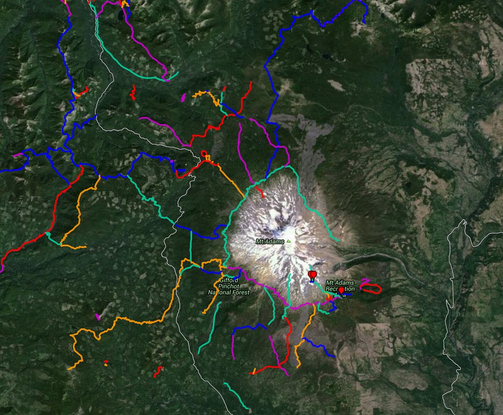 All of Mount Adams' Trails, both official and abandoned or "lost"
 by
fluttershyismagic, on Flickr
http://gpsfly.org/g/5156
EDIT:
Here is an updated gpx file. I accidentally left out the Dry Creek Trail in the Bird Creek Meadows area.
Last edited by
Naturebat on November 21st, 2015, 9:18 pm, edited 2 times in total.
- Previously ElementalFX
-
mayhem
- Posts: 3579
- Joined: December 22nd, 2009, 7:46 pm
-
Contact:
Post
by mayhem » November 21st, 2015, 9:47 am
Coolio! When I really start getting out i have another resource.
Thank you & all of the ponies you came in on or with

Shoe Shine Boy Has Left The Building!
-
aiwetir
- Posts: 603
- Joined: December 10th, 2014, 11:54 am
-
Contact:
Post
by aiwetir » November 21st, 2015, 9:49 am
I haven't zoomed in on all of these tracks yet, but how were they generated?
EDIT: Never mind, I saw the answer in your other posts.
- Michael
-
Naturebat
- Posts: 315
- Joined: January 27th, 2013, 9:18 pm
Post
by Naturebat » November 21st, 2015, 9:11 pm
So, I made a small mistake on the GPX file I uploaded. I left out the Dry Creek Trail at Bird Creek Meadows. I added it in and replaced the old file with a new one.
I'll also link it in this post here.
New file:
- Previously ElementalFX
-
drm
- Posts: 6154
- Joined: May 28th, 2008, 10:03 pm
- Location: The Dalles, OR
-
Contact:
Post
by drm » November 22nd, 2015, 12:51 pm
Stagman Ridge doesn't seem to be properly represented. It's not connected.
-
romann
- Posts: 2417
- Joined: May 28th, 2008, 10:03 pm
- Location: Vancouver, WA
Post
by romann » November 24th, 2015, 1:00 am
Oh wow! This is cool idea - and a lot of work, to gather all tracks in one file. I stole one copy.
It doesn't load on Google Earth, but it works well on my GPS.
Stagman trail looks right to me; there's indeed (per old topo map) another trail that goes down below @ lower Cascade Creek and dead-ends there without connecting to anything.

 All Mount Adams Trails GPS File-23008.gpx


