
2014 Snow Level Thread
Re: 2014 Snow Level Thread
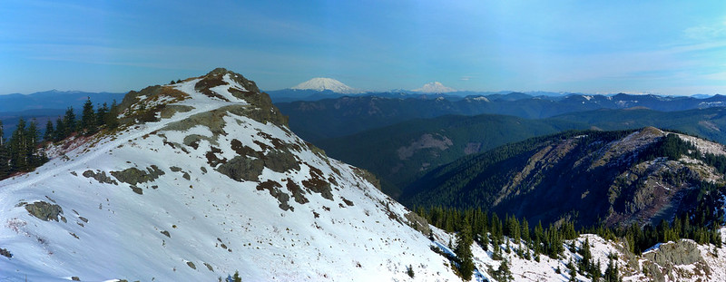
No appreciable snow on Silver Star, January 4.
Rambling on at Allison Outside

Re: 2014 Snow Level Thread
Greetings All -
Does anybody have an idea (guess?) of the snow levels on Tanner Butte right now in the Gorge, between Dublin Lake and the Tanner Butte viewpoint?
I was guessing it had 1 foot to 18 inches of snow after last week at 4500 feet elevation, but now I am not so sure.
I want to go up there tomorrow (Sat 1/18) from Wahclella Falls TH and am trying to decide whether I need to bring snowshoes. It will be a long day (into the early evening), but an adventure for sure.
Thanks for any info, guesses, predictions, tea leaves, etc.
-CraigG
Re: 2014 Snow Level Thread
Mt. Hood, 6800', east side (Gnarl Ridge on right, Heather Canyon on left), January 17.

The snow is very consolidated.
The snow is very consolidated.
Rambling on at Allison Outside

Re: 2014 Snow Level Thread
We were in the Gifford Pinchot Sat, Jan 18, on the 66 road along the east side of Big Lava Bed. First snow on road just below 3,000 ft. Got up to the jct at S Prairie, just above the Little Huckleberry TH, 3,100 ft. A couple of inches. As far as we felt comfortable going without chains. S Prairie covered with ice. Did have some water in the lake about 2 months ago, which froze over about 4 inches thick. Water now all drained, ice now laying on grass. Strange to see.
Last edited by K.Wagner on January 19th, 2014, 12:59 pm, edited 1 time in total.
Kelly
There is no shortcut to anyplace worth going to.
PM me about the soon to be released:
Skamania 231
"How to really get off the beaten path in Skamania County"
There is no shortcut to anyplace worth going to.
PM me about the soon to be released:
Skamania 231
"How to really get off the beaten path in Skamania County"

Re: 2014 Snow Level Thread
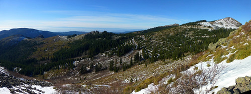
Similar report to Kelly's. We ran into a couple-few inches of snow at about 3000' on Silver Star yesterday (1/18), though all the roads around it are just fine. (People were even using the north trailhead!) Above 4000', the snow was anywhere from 6"-18", mostly consolidated and easy to walk on. It was patchy off-trail, deeper in more sheltered areas; more than a few times we plunged in to our knees. We were still glad we "hadn't bothered" to bring snowshoes, though! They would've been far more trouble than they'd have saved.
55° on the summit, with light breeze.
As we descend cross-country, it was 72° here! That white stuff between rocks and beargrass easy to sink into.
55° on the summit, with light breeze.
As we descend cross-country, it was 72° here! That white stuff between rocks and beargrass easy to sink into.
Karl
Back on the trail, again...
Back on the trail, again...
-
payslee
Re: 2014 Snow Level Thread
Thanks for the road updates yesterday Karl! Made it over the 1200 without trouble, althought the obliterating clearcut at the Skamania Mines junction almost got me lost 
While you were enjoying balmy sun it was about 38 degrees along the river at Moulton
-payslee
While you were enjoying balmy sun it was about 38 degrees along the river at Moulton
-payslee
Re: 2014 Snow Level Thread
My pleasure, payslee! One of these days, our paths will actually cross up there.
We couldn't believe that logging operation, either. His instrument of death was operating right in the middle of the road, when we came up. We sat there, in total awe, at what it could do. Really wished, afterward, to have had the presence of mind to whip out a video of it.
It was soooooooo good to get up out of the fog!!! Been sitting under it all week long. Still looked like most of the Tualatin and Willamette valleys were suffering from it, though most of Clark County looked relatively clear.
Karl
Back on the trail, again...
Back on the trail, again...
Re: 2014 Snow Level Thread
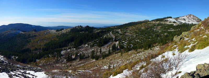
Karl,
In your last picture, not sure of the orientation. Are you looking basically south, with Pyramid Rock on the ridge line to the left & Sturgeon Rock poking over the ridge on the right?
In your last picture, not sure of the orientation. Are you looking basically south, with Pyramid Rock on the ridge line to the left & Sturgeon Rock poking over the ridge on the right?
Kelly
There is no shortcut to anyplace worth going to.
PM me about the soon to be released:
Skamania 231
"How to really get off the beaten path in Skamania County"
There is no shortcut to anyplace worth going to.
PM me about the soon to be released:
Skamania 231
"How to really get off the beaten path in Skamania County"

Re: 2014 Snow Level Thread
I was on Benson Plateau 1-18. No snow or ice at all on the way up from Herman Creek. This shot is from Benson Spur and Ruckel Creek trail intersection. The snow seems to be mostly on the western and southern sides of the plateau. The creek is flowing nicely.
- Benson Ruckel/PCT.
Last edited by turtle on January 19th, 2014, 3:11 pm, edited 1 time in total.
Summer breezes caressed me, my legs stepped forward as though possessed of their own appetite, and the mountains kept promising. Rebecca Solnit
Re: 2014 Snow Level Thread
Well, I would've said "basically west", but yeah Pyramid on the left and Sturgeon/Star2 on the right. It's three images stitched together, spanning about 135° horizontally.K.Wagner wrote:Karl, In your last picture, not sure of the orientation. Are you looking basically south, with Pyramid Rock on the ridge line to the left & Sturgeon Rock poking over the ridge on the right?
- Location and approximate span of photo.
Karl
Back on the trail, again...
Back on the trail, again...