Page 1 of 3
Eagle Creek Map Error!
Posted: April 10th, 2012, 6:54 pm
by Splintercat
Chatting offline with another PH'er, and noticed that Metlako Falls is incorrectly identified on the USGS map! Check it out:
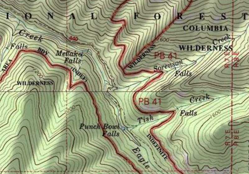
Okay, so maybe this is old news and I've been checked out... but it should be mapped just above the junction (or nearly at the junction) with Sorenson Creek, right? The falls marked "Metlako" is actually the low falls that appears in Jamey's epic winning photo of the lower gorge. Odd that Sorenson Falls isn't even mapped -- it's quite substantial, and year-round, too.
Well, I guess those USGS cartographers are human, too...

-Tom

Re: Eagle Creek Map Error!
Posted: April 10th, 2012, 10:38 pm
by pyles_94
Oh yeah, I've seen this one... However, not to give too much away, that is the approx. location of the weeping wall.
Re: Eagle Creek Map Error!
Posted: April 11th, 2012, 12:19 am
by potato
Splintercat wrote:
Odd that Sorenson Falls isn't even mapped -- it's quite substantial, and year-round, too.
Sorry, but isn't it marked on the map right there, just right of center?
Re: Eagle Creek Map Error!
Posted: April 11th, 2012, 8:45 am
by Don Nelsen
Tom, yeah, I've noticed that too. Not too unusual to have errors, though, and there's too many to count and just seem to go on forever.
Here's a pic I took of Metlako last year and my GPS track showing where I took the photo from. (I seldom correct my camera's time from or too daylight savings so it's an hour off)
Metlako normal lens:

close up:

GPS track:

dn
Re: Eagle Creek Map Error!
Posted: April 11th, 2012, 9:09 am
by Koda
a lot of the maps we use today are old technically, created by aerial surveying. Are there any plans to update the usgs topo maps?
Re: Eagle Creek Map Error!
Posted: April 11th, 2012, 10:05 am
by Splintercat
@Rad -- sorry, I should have said that it's on the map, but in the wrong spot...
Tom
Re: Eagle Creek Map Error!
Posted: April 11th, 2012, 10:52 am
by CampinCarl
Koda wrote:a lot of the maps we use today are old technically, created by aerial surveying. Are there any plans to update the usgs topo maps?
The current generation is called US TOPO and Oregon's were updated in 2011.
Here's a link to the spot we're discussing
USGS Store
Unfortunately, the methodology has been changed and trails (among other features) are not being included at this point. See this thread
New US TOPOs & historic topo quads now available for Oregon
Re: Eagle Creek Map Error!
Posted: April 11th, 2012, 10:56 am
by CampinCarl
You can also always be a helpful citizen and report errors you see on the map

See question 2 for details.
U.S. Board on Geographic Names
Domestic Names - Frequently Asked Questions (FAQs)
Re: Eagle Creek Map Error!
Posted: April 12th, 2012, 1:20 am
by Water
CampinCarl,
Don't waste your time reporting errors. the USGS 2011 Mt. Hood Map is horribly incorrect (SplinterCat and I discussed this offline). I sent a polite email to them with plenty of caveats that I certainly may be out of my element but it seems like a number of mislabeled items (leuthold coulior at illuminsation saddle, camp blossom [timberline area] located directly west on the ridge from ill saddle..Sandy Glacier Headwall is located at Leuthold Coulior, triangle moraine is over in no-mans land by newton clark glacier, across from white river glacier). They sent a semi-snippy response pointing out a few instances where I pluralized a name (leutholds coulior, castle crags, etc) and said someone would be getting in contact with me.
twas perhaps 4-5 months ago..
Re: Eagle Creek Map Error!
Posted: April 12th, 2012, 6:28 am
by CampinCarl

Sorry for your unpleasant experience. I work in the Geographic Information System (GIS) field and I've met the
USGS Geospatial Liason for Oregon.
In a talk I attended a couple of years back, she was part of the panel that discussed the agency's desire to improve the accuracy of the GNIS. I'm not sure why it would be poo-pooed when someone actually wants to help
