Page 11 of 14
Re: Open Source TOPO map/GPS software...
Posted: May 24th, 2013, 10:29 am
by RobFromRedland
kepPNW wrote:RobFromRedland wrote:Just curious - have you taken that track that you list and run it through the GPSies to see how the different levels of simplification affect the track? It would be interesting to see one map with the same track in different colors that had been run through the tool to see how they differ. I'm not sure I have any tracks that I haven't cleaned up so I can do that. The one you posted would be a GREAT one to try.
I haven't, but I'd be happy to try. I'd like to see exactly what it does, too, on a track I was very familiar with. The beauty of that one is I have three different units all recording the same hike, so it's a great one for comparisons.
I got very disappointed in GPSies, very quickly, though after first signing on there. I found they totally ignore the timestamp in the GPX files! Wrote the author/owner, and he said that most tracks he'd ever seen didn't have them, so, in a few words, "tough luck." I just couldn't imagine a more ignorant response, and pretty much never went back.
So, if I were to try this, does it offer you a SaveAs on the smoothed track? Or do I need to upload it three times under different names? Or...?
Thanks!
Hadn't seen anything posted about this - Wondering if you had a chance to try the differerent levels of simplification and how it worked? I'm dying to see the results....
Re: Open Source TOPO map/GPS software...
Posted: May 24th, 2013, 9:07 pm
by kepPNW
RobFromRedland wrote:Hadn't seen anything posted about this - Wondering if you had a chance to try the differerent levels of simplification and how it worked? I'm dying to see the results....
I hadn't really tried yet. Well, logged in there, got frustrated with their interface again, and sorta forgot about it, I'm afraid.

Re: Open Source TOPO map/GPS software...
Posted: May 25th, 2013, 5:30 pm
by Koda
I have yet to try this one but here is something that might have potential:
http://www.gpstrackeditor.com/
from their 'Features overview' page: (bold emphasis mine)
GPS Track Editor Overview
GPS Track Editor is a Windows application for editing GPS tracks.
GPS track is an ordered sequence of points with latitude, longitude, date, time, and maybe some other parameters.
Unfortunately coordinates obtained from a receiver are not precise. GPS errors are affected by a number of reasons that cannot be eliminated. For example the receiver can show some movement while standing still.
GPS Track Editor can help you to clean up your tracks. Some deviations are processed automatically but you can always control the result and edit a part of the track manually.
Features:
Open and save tracks (GPX, NMEA, Magellan SD
are supported).
Display the trajectory of your movement.
Track point filter by parameter limitation.
Adjust track structure, rename segments.
Manually deleting, inserting, moving points,
work with fragments of a track or a set of tracks.
Merge or combine several tracks into one.
Re: Open Source TOPO map/GPS software...
Posted: May 25th, 2013, 6:29 pm
by kepPNW
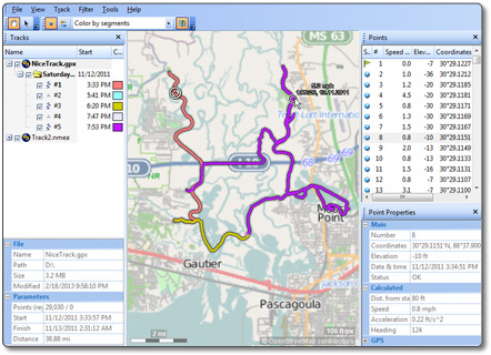
Wow! Try it. I just ran it against that Indian Point track I posted a graphic of earlier. All I did was tell it to to filter "Local Inconsistencies" and it nailed most of the spots where I'd stopped but my GPS hadn't. Only downside was, it also mistook a couple of switchbacks as such problems. But the upside to that downside is, you can easily pan around the track and A) see what it's filtered, and B) "restore" filtered points it shouldn't have. This is really easy to do, as the ones you want to restore are few and far between. At least on the first track I tried. This seems to be exactly the tool we were all hoping to find! And it's free, too, as best I can tell.

Thanks much!!!
Re: Open Source TOPO map/GPS software...
Posted: May 25th, 2013, 6:40 pm
by Koda
I think the program is freeware, but not certain. Its good to hear a wow recommendation on this as I have not had time to play with it yet. My only problem is its windows based and I run Linux. The program opens with Wine (Linux compatibility program) but did not run so well, my only other option is to run it inside a virtual machine which will work but is slow. I know, my own undoing... Linux rocks.

So anyways, I'll make certain I add it to my list with a thumbs up but feel free to let us know its ins and outs.
Re: Open Source TOPO map/GPS software...
Posted: May 25th, 2013, 6:49 pm
by kepPNW
Definitely a Winders critter, yeah. And it doesn't do a whole lot, but what it does is done exceptionally well, it seems! (Caveat: I've only played with it for 5-10 minutes!) What I really like is something I haven't seen in any other editor - it has a "transactional" model for editing. That is, you filter points by whatever criteria, add and remove points to the filter, and finally "commit" the edits. Or cast them aside. Very slick. Seems it'd be pretty easy to overwrite an existing track, so you'll want to be sure to do a SaveAs if you want to keep the original intact.
Looks like it'll do a few other "odd jobs" I've wanted to find a way to accomplish. Next thing I'll try is combining a bunch of tracks from the same area(s). Could be a really nice way to consolidate a lot of info.
Initial impression, yeah, it's definitely worth becoming familiar with, and knowing when to use.
Re: Open Source TOPO map/GPS software...
Posted: May 25th, 2013, 7:00 pm
by Koda
it looks like I already added it to the list (see OP) whenever it was I found it. Thanks for the input Kep. Looks like it will be worth running in virtualbox...
here is another freeware windows only program I used a lot when I used windows.
http://www.easygps.com/. The freeware does not edit much, but its a fast easy interface with the device. The pro version though says "Unlimited topo maps and aerial photos!
Combine GPS, CAD, and GIS data
View your GPS data in Google Earth", that might have potential for the GIS users.
Re: Open Source TOPO map/GPS software...
Posted: May 26th, 2013, 5:52 am
by RobFromRedland
I had tried GPSTrackEditor earlier, but I guess I hadn't given it a fair shake. It looked too much like other tools I had and I didn't think I needed yet another track editor. I think that "filter local inconsistencies" looks like it has a lot of potential, and you are correct, restoring points removed in error is really easy. Thank you for posting this. I think I will have to use this on some of my upcoming tracks to see how it works with them. It will be much easier for me to experiment with a fresh track than one I did a long time ago.
Re: Open Source TOPO map/GPS software...
Posted: May 27th, 2013, 3:20 pm
by rainrunner
On my old computer, I had installed the TerraGo Toolbar as an add-on for Adobe reader.
This program would allow me to measure my hikes on topographic maps which were in pdf format.
Here is the link to the download page:
TerraGo Toolbar
Re: Open Source TOPO map/GPS software...
Posted: May 29th, 2013, 5:15 pm
by RobFromRedland
I did a hike (a very wet hike) on Memorial day, and used GPS Track Editor to clean up the tracks - between the filter local inconsistencies and filter by value (using 5mph), it did a great job of cleaning up the track. Had a couple spots where we stayed put for a while, and got the "spider on acid" track - it cleaned those up very nicely. I don't think it really removed any points in error, although there weren't any switchbacks on this hike.
I will be using this program again.....