
Im specifically looking for a map of the Tillamook State forest and cannot find any source to acquire one. So my first question here is does anyone know?
(I'd also be interested in a map soource for any of Oregons state forests...)
I have a good copy of the Tillamook state forest map but, its no longer published. I keep using it but its wearing out fast, its the only reliable map I know of. Its your typical huge fold out map not unlike any national forest map you buy. If there is no current source to buy a new one...
my second question is there any way to replicate this map electronically, full scale?
(I'll post a picture of the map when I get home if it helps)
Oregon State Forest maps, source and/or replication...
Oregon State Forest maps, source and/or replication...
lightweight, cheap, strong... pick 2
Re: Oregon State Forest maps, source and/or replication...
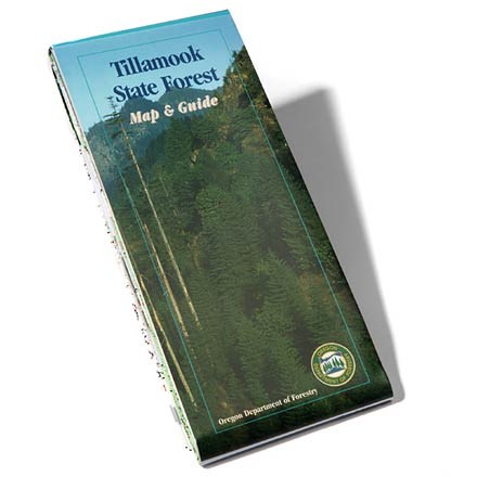
this is the map I have... https://www.rei.com/product/695434/till ... -and-guide
since I cant find a source to buy another one, does anyone know a way to replicate this map digitally or otherwise?
since I cant find a source to buy another one, does anyone know a way to replicate this map digitally or otherwise?
lightweight, cheap, strong... pick 2
Re: Oregon State Forest maps, source and/or replication...
There are a few places around that do large format scanning, generally for art reproductions, but it works in this case. We recently got one of the old gorge maps scanned... It can be a little expensive for a one off, but better than trying to scan pieces and stitch it back together.
I'll look around, I may have some copies of that map
I'll look around, I may have some copies of that map
Re: Oregon State Forest maps, source and/or replication...
I was wondering if someplace like Kinkos could handle that. Id even consider cutting the map in half...
...and as long as it wouldnt cost too much. If so, then Im kinda nerdy enough to scan it at home in 8.5x11 pieces...
(it really is the best map of the Tillamook State Forest....)
...and as long as it wouldnt cost too much. If so, then Im kinda nerdy enough to scan it at home in 8.5x11 pieces...
(it really is the best map of the Tillamook State Forest....)
lightweight, cheap, strong... pick 2
-
CampinCarl

- Posts: 573
- Joined: June 17th, 2011, 7:41 am
- Location: Salem
Re: Oregon State Forest maps, source and/or replication...
You might also contact the GIS team at ODF- [email protected] and see if they have a copy of the map digitally in archives somewhere. They may be able / willing to send it to you. Not sure if they would charge or not. It's worth a shot, anyway.

Re: Oregon State Forest maps, source and/or replication...
Cut it up and scan it in chunks. I could do it if you can wait a month
- Michael
-
kaltbluter

- Posts: 397
- Joined: June 2nd, 2014, 10:36 am
Re: Oregon State Forest maps, source and/or replication...
[quote="Koda"]I was wondering if someplace like Kinkos could handle that.
Fedex Office can copy pretty large engineering drawings. Call around to find a location that does large format scanning.
Fedex Office can copy pretty large engineering drawings. Call around to find a location that does large format scanning.
Re: Oregon State Forest maps, source and/or replication...
I have already emailed the Oregon Forestrys generic contact email and no reply yet. Thanks for the more direct email contact though, I will give that email address a tryCampinCarl wrote:You might also contact the GIS team at ODF- [email protected] and see if they have a copy of the map digitally in archives somewhere. They may be able / willing to send it to you. Not sure if they would charge or not. It's worth a shot, anyway.
lightweight, cheap, strong... pick 2
Re: Oregon State Forest maps, source and/or replication...
I think this will have to be my next step if I exhaust all efforts to buy a new one. I really dont want to cut up my map in 8x11 chunks and scan at home... I've tried carefully folding it but then the edges were a little blurry from the scanner, this worked though for the area I regularly visit so I didn't have to wear out my real map.kaltbluter wrote:Koda wrote:I was wondering if someplace like Kinkos could handle that.
Fedex Office can copy pretty large engineering drawings. Call around to find a location that does large format scanning.
Here is a 1:1 screenshot of a sample of a scanned portion of the map. This is the only map I have ever seen of the TSF that actually shows all the roads and very accurately too including spur roads. The topography level is good enough to navigate off trail, the map does come alive in color. You can see why I need to preserve this map....
- Attachments
-
lightweight, cheap, strong... pick 2

Re: Oregon State Forest maps, source and/or replication...
Rather than folding and scanning Koda maybe try photographing then cropping and stitching.