Nav Work 105 - Coordinate Systems! Datum, Lat/Long, UTM

Cartography, maps, navigation, GPS and more.
Lurch
Posts: 1270
Joined: May 28th, 2008, 10:03 pm
Location: Aurora
Contact:

Nav Work 105 - Coordinate Systems! Datum, Lat/Long, UTM

Post by Lurch » November 24th, 2014, 9:50 pm

Alright y'all, I guess it's time for another holiday season Nav thread!

Coordinate Systems

Datum
Lat / Long


We all know the basics of coordinate systems, and why they're important. They allow us to identify specific locations on the planet, and they also let us plot them into a map. I'll briefly go over Latitude and Longitude, and hopefully do UTM in a followup post shortly.

But first!

MAP DATUM

Extremely simplified down, you can think of the 'map datum' as the mathematical model that describes the size and shape of the planet. I believe we can all agree that the planet is *roughly* spherical. If you have a balloon and change the amount of air in it the points on the surface will move. If you change the model of the planet with a coordinate grid on it, than the various coordinates laid on top if it are going to change in relation. This is called datum shift, and *must* be accounted for if you're working between datums. The two most common map datums in use are NAD27, and WGS84.

Image

NAD 27 (North American Datum 1927) was established in *gasp* 1927! It's based of the Clarke Ellipsoid of the planet built in 1866. All in all, for being calculated out in 1866 it was remarkably accurate! NAD27 uses an origin point in Kansas, designed to mitigate errors in the model through North America. This is the "default" datum for oldschool USGS quads, although ones with a more recent revision/print date may have 'compensation marks' printed on to convert between datums.

WGS84 (World Geodetic System 1984) is obviously much newer. With fancy satellites and a few hundred thousand incredibly accurate measurements it creates a much more accurate model of the planet.

For our practical purposes, there isn't that much of a difference between the two. The caveat being that virtually all modern technology is going to be designed to function in WGS84. Your cellphones, GPS, Google Maps, etc. The whole map datum thing could get incredibly technical, but I guess the important bit is to remember you need to know what your map is in! If your map is printed in NAD27 (like most oldschool 7.5 minute quads) and your GPS / Cellphone is working in WGS84 your coordinates are not going to land where you're expecting them to. For us around here datum shift is really only a couple hundred meters, but that can be quite significant.

Latitude and Longitude

Latitude and Longitude would probably be what most people consider the 'standard' coordinate system. This will be the default in most GPS units, it's what virtually all online mapping sites will use, as well as cellphone pings, etc.

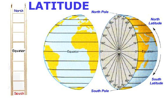
The earth revolves around an axis, we as a people have defined where that axis comes out of the planet as the poles, and arbitrarily decided one as North, and the other as South. Halfway in between we've defined the 'equator' dividing the two. This is a line of latitude that defined by the planet, not by use lowly humans, we just put names on them.

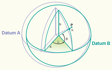
Latitude is further divided radially from the equator North 90° and South 90° This creates concentric 'rings' parallel to the equator, measuring degrees North and South

Image

Longitude is measuring around the planet. These lines converge at the poles, and are furthest apart at the equator. We've decided (arbitrarily) that the 0° mark will be running through Greenwich, England. We like to call that it the Prime Meridian, because it's a fancy name and makes it sound important. Opposite of that is the 180° mark, commonly called the International Date Line, although that's not entirely accurate. The 180° meridian is straight, where the IDL *mostly* follows it, but zigzags around to do things like keep Alaska all in the same day..

Image

Although we've already established that there are 360° in a circle. Coordinates in Lat Long don't like to follow the rules. Latitude is measured 0-90° North/South of the Equator, and Longitude being 0-180° East or West of the Prime Meridian. If we want to get more accurate than that it starts to get tricky... Lat Long is commonly read in one of 3 formats, 1: D°.Decimal Degrees, ie 45.0000°N 122.0000°W 2: D° Minutes'.Decimal Minutes, is 45° 30.000'N 122° 30.000'W or 3: Degrees° Minutes' Seconds"

You can think of Degrees like hours. There are 60 minutes in a Degree, generally designated with a single hash ' and 60 seconds in a minute, with a double hash ". The first D.dddd° is becoming more and more common, you car GPS, cellphones, and most aircraft will be operating in this. It's easier to punch into a computer.

Couple notes to remember if you're actually working on plotting these out on a map. Lat Long as a geographic coordinate system is a series of curved lines, it can be difficult to accurately calculate things like distance, area, and even directions some times. For instance, this satellite orbit is a "straight line" (simplified actually, that particular image takes the rotation of the earth in relation to the satellite out of the equation... )

Image

Lat Longs should always be read Latitude then Longitude. Latitude is measuring Degrees North of the equator, where Longitude is measuring Degrees West of the Prime Meridian. Sometimes it will be expressed as Negative Degrees East, but they're the same thing, it's just easier for most people to work with positive numbers.

Just to make things a bit more confusing... The following sets of coordinates ALL represent the same location (Angels Rest) showing the three different formats of Lat/Long, and the shift caused by switching datums.

WGS84
45.5643°N 122.1533°W
45° 33.858'N 122° 9.198'W
45° 33' 51.48"N 122° 9' 11.8"W

NAD27
45.5645°N 122.1521°W
45° 33.87'N 122° 9.126'W
45° 33' 52.2"N 122° 9' 7.2"W
latlong.jpg
This isn't generally the technique I would teach for finding coordinates, but it works in a pinch. Please note that the scales for Latitude and Longitude are *different*. One degree in one scale is not the same physical distance as 1 degree in another. In fact, 1° of Longitude is not the same physical distance depending where you are on the planet! In this particular map there are 2" tick marks along the margin, with index lines every 30".

If I'm going to plot, or find coordinates, the first thing I like to do is find the 'box' that they will be in. In this case, finding Angels Rest I know it will fall somewhere between 45° 33' 30" - 45° 34' 00"N and 122° 09' 00" - 122° 09' 30"W. Using the scales on the margins I can build a simple reader/ruler to determine what latitude N of the of 45° 33' 30"N line, and West of the 122° 09' 00"W line I am.

UTM's to come! I just wanted to get that out and posted or I know I probably wouldn't do it before the new year... Please please please ask questions if you have them. The main reason I do these threads is to interact and help out. No response = no fun!

User avatar
Koda
Posts: 3466
Joined: June 5th, 2009, 7:54 am

Re: Nav Work 105 - Coordinate Systems! Datum, Lat/Long, UTM

Post by Koda » November 24th, 2014, 11:01 pm

Lurch, to clarify in my head... is everything WGS84 zeroed at the Prime Meridian and everything NAD27 zeroed at its origin point in Kansas? (longitudinally)
lightweight, cheap, strong... pick 2

Lurch
Posts: 1270
Joined: May 28th, 2008, 10:03 pm
Location: Aurora
Contact:

Re: Nav Work 105 - Coordinate Systems! Datum, Lat/Long, UTM

Post by Lurch » November 24th, 2014, 11:57 pm

Negative, WGS84 is actually a geodetic datum that is geocentric to within about 6 feet. It's based off the actual center of mass of the planet, and has much better capabilities in 3d modeling and can actually supply vertical coordinates and not just horizontal like NAD27... All that's beyond the accuracy of most paper maps, or our needs in the wilderness though.. unless you *really* need to know things to the subcentimeter accuracy...

User avatar
Koda
Posts: 3466
Joined: June 5th, 2009, 7:54 am

Re: Nav Work 105 - Coordinate Systems! Datum, Lat/Long, UTM

Post by Koda » November 25th, 2014, 11:19 am

ok, good. The NAD27 origin in Kansas got me confused with the Agonic line... witch is a different subject.

So the short answer to your post is to always use WGS84 for everything and avoid buying NAD27 maps?
lightweight, cheap, strong... pick 2

Lurch
Posts: 1270
Joined: May 28th, 2008, 10:03 pm
Location: Aurora
Contact:

Re: Nav Work 105 - Coordinate Systems! Datum, Lat/Long, UTM

Post by Lurch » November 25th, 2014, 12:14 pm

Not necessarily. NAD27 maps are only going to be a problem if you're planning on plotting coordinates onto them by hand. Even if you are, you can set your GPS to NAD27 and be more than accurate for anything us normal folk will be doing in the wilderness. By default your modern electronics, and coordinates you pull off most digital sources (mapping websites) are going to be in WGS84. That is the standard

Bearings and general navigation (terrain features and such) don't care which datum the map is in. True North is still True North (Grid North may shift by the tiniest of margins). Even if you are working off multiple sources the GPS can convert between them with ease, just make sure you have the datum set properly when you input a set of coordinates, then you can change the GPS Datum and it will do the conversions for you.

If you're posting coordinates on the forum here (or anywhere really) or talking to SAR (hopefully not, but if you were a subject who handed us coordinates that would be mighty helpful!) We're most likely going to be working in WGS 84.. Or just make a point of noting the datum.

One that you *may* see once in awhile is NAD83, which for all intents and purposes this is identical to WGS84 and can be treated as such.

Wikipedia is kind enough to supply a rough map of datum shift throughout the US between the two

Image

The origin point for NAD27 had nothing to do with the agonic line (that moves btw). It was chosen as being relatively close to the geographic center of the Continental US (missed it by about 42 miles) and in theory falls on the intersection of the 39th Parallel (39°N) and 98th Meridian West (98°W). Going off the 'center' of the country, they could mitigate the errors coast to coast that they knew were inherent in the system.

User avatar
sprengers4jc
Posts: 1036
Joined: October 22nd, 2013, 11:35 am
Location: Vancouver, WA

Re: Nav Work 105 - Coordinate Systems! Datum, Lat/Long, UTM

Post by sprengers4jc » November 25th, 2014, 4:14 pm

Great info, thank you!
'We travel not to escape life but for life to not escape us.'
-Unknown

Joseph Elfelt
Posts: 157
Joined: September 3rd, 2010, 10:24 am
Contact:

Re: Nav Work 105 - Coordinate Systems! Datum, Lat/Long, UTM

Post by Joseph Elfelt » December 27th, 2014, 5:24 am

Lurch,

When you do the UTM writeup, it might be helpful to include a Gmap4 map with the UTM grid turned on.

Also, a right click on the map will display coordinates for the spot you clicked in all the common formats.

Finally, Menu ==> "UTM - USNG - LatLng" lets you change the format for the coordinates that appear in one corner of the screen.


Joseph, the Gmap4 guy

User avatar
johngo
Posts: 50
Joined: July 30th, 2015, 9:41 am

Re: Nav Work 105 - Coordinate Systems! Datum, Lat/Long, UTM

Post by johngo » February 11th, 2016, 6:56 pm

Lurch,

I give you a big high-five for your willingness to post an educational series of lessons like this.

You clearly know your stuff, and sure a lot of people can benefit from it.

I have tried to do something similar on some other forms, and you cannot believe the amount of egotistical chest beating that some people feel compelled to do about denigrating someone's efforts to put up some helpful resources like what you're doing.

So, thanks, and keep up the good work.

User avatar
johngo
Posts: 50
Joined: July 30th, 2015, 9:41 am

Re: Nav Work 105 - Coordinate Systems! Datum, Lat/Long, UTM

Post by johngo » June 29th, 2016, 7:13 am

I made a series of navigational instruction videos.

You can find them on YouTube. Search for "Columbia River orienteering club"

I have one on UTM coordinates, both myself and my navigation students think it explains it quite well, and you should have a very good grasp of the concept after you watch the video.

You can see it here:
https://www.youtube.com/watch?v=qstBRB8Og18

User avatar
Chase
Posts: 1265
Joined: May 28th, 2008, 10:03 pm

Re: Nav Work 105 - Coordinate Systems! Datum, Lat/Long, UTM

Post by Chase » June 29th, 2016, 8:01 am

Wait, so when can we start using the US National Grid?

Post Reply