Drawing tracks in Google Earth

Cartography, maps, navigation, GPS and more.
Post Reply
User avatar
adamschneider
Posts: 3716
Joined: May 28th, 2008, 10:02 pm
Location: SE Portland
Contact:

Drawing tracks in Google Earth

Post by adamschneider » October 9th, 2013, 12:57 pm

(continued from the "St Helens 10.4.13" thread...)
kepPNW wrote:
adamschneider wrote:
kepPNW wrote: Tracing? Sounds like something I oughta be familiar with, maybe by another name?
It's not jargon; I mean literally drawing a new track manually on top of the "real" track(s). I reduce the opacity of the existing tracks and use them as a rough guide, but rely mostly on the aerial imagery whenever possible.
Oh wow. That was my first thought, but then, "no way, really?" :)

Why do you feel that's more accurate than what the GPS records? Seems incredibly laborious. Like what we were doing back in the 80's when GIS were still mostly theoretical. I mean, I can sure see the appeal of tracing along visible trails, but the flipside of that is that the image rectification isn't all that wonderful or the feature has moved (happens!) over time.
Sure it's laborious. I said "most accurate," not "easiest"!

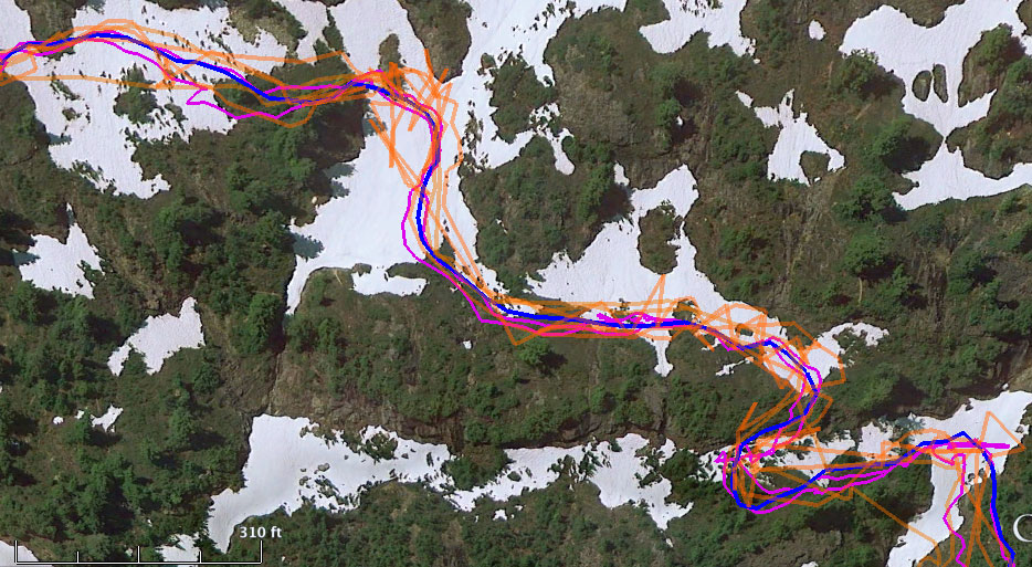
GPS readings can be complete crap at times; we all know this. Often I do an out-and-back hike, and my "out" track is 20 meters away from my "back" track. Sometimes they line up for a while, then one drifts off to the west for a while, then it comes back when another satellite comes into view, or because the GPS gnomes got off their lunch break, or who knows why. You see this even when you're standing still.

If I had a really good signal all day, sometimes I'll simply edit the track I recorded: I move obviously wild points back in line, and I delete the tangled knots that form when I take breaks. But I've come to realize that editing existing tracks can take even more time than just drawing a good clean line on top of what's there.

As for the accuracy of the aerial photography... well, for one thing, in my experience, it's more accurate than most GPS tracks — and it's way better now than it was even 10 years ago. Also, when I'm tracing a clean track, it's usually because I want to get an accurate idea of the distance traveled, rather than the exact position within 2 meters. If the photography for a parcel of land is mis-aligned, oh well... the relative distances are still the same.

Obviously, tracing works best for hikes in open country where the trails are visible from above. Of course, that's when you're also likely to get a good GPS reading... unless you're in a valley, or next to a cliff. Cliffs are even worse than trees when it comes to screwing up your GPS. (When you're under trees, your GPS has trouble and you can't see anything on the aerial photos, so true precision is a lost cause there.)
Last edited by adamschneider on October 9th, 2013, 1:22 pm, edited 1 time in total.

User avatar
adamschneider
Posts: 3716
Joined: May 28th, 2008, 10:02 pm
Location: SE Portland
Contact:

Re: Tracing tracks in Google Earth

Post by adamschneider » October 9th, 2013, 1:12 pm

Here's an example... before I went to Gothic Basin (in the North Cascades), I downloaded as many GPS tracks as I could find online, from EveryTrail and Trimble Outdoors. On the Google Earth view below, the orange tracks are other people's data. The magenta tracks are the ones I actually recorded when I was there. (Note that the orange and magenta lines span about 50 to 80 feet across the trail.)

The blue line is my after-the-fact "trace" — which I feel much more confident about, since I could see the trail in GE when I was drawing it.

Image

User avatar
kepPNW
Posts: 6411
Joined: June 21st, 2012, 9:55 am
Location: Salmon Creek

Re: Drawing tracks in Google Earth

Post by kepPNW » October 9th, 2013, 2:35 pm

Well Adam, in whole, no disagreement.

I think it's correct to say that the orthophotos are reasonably consistent internally if your purpose is to measure a route. I'm pretty sure the measurement will consistently come up short, too. That's the nature of generalization.

But yeah, for depiction on maps/images, I have no doubt what you're doing is going to yield the best results. :)
Karl
Back on the trail, again...

User avatar
adamschneider
Posts: 3716
Joined: May 28th, 2008, 10:02 pm
Location: SE Portland
Contact:

Re: Drawing tracks in Google Earth

Post by adamschneider » October 9th, 2013, 2:45 pm

kepPNW wrote:I think it's correct to say that the orthophotos are reasonably consistent internally if your purpose is to measure a route. I'm pretty sure the measurement will consistently come up short, too. That's the nature of generalization.
Yeah, it might be a little bit short -- but I figure it's a good baseline. In other words, this is the distance you'll travel if you walk right in the middle of the trail, don't meander over to viewpoints, never stop for lunch, never take pictures, etc. (For trail runners, that might be pretty close to the truth.)

On the other hand, I've seen raw GPS tracks that claimed to be twice the real distance due to the wandering signal!

User avatar
kepPNW
Posts: 6411
Joined: June 21st, 2012, 9:55 am
Location: Salmon Creek

Re: Drawing tracks in Google Earth

Post by kepPNW » October 9th, 2013, 2:51 pm

adamschneider wrote:
kepPNW wrote:I think it's correct to say that the orthophotos are reasonably consistent internally if your purpose is to measure a route. I'm pretty sure the measurement will consistently come up short, too. That's the nature of generalization.
Yeah, it might be a little bit short -- but I figure it's a good baseline. In other words, this is the distance you'll travel if you walk right in the middle of the trail, don't meander over to viewpoints, never stop for lunch, never take pictures, etc. (For trail runners, that might be pretty close to the truth.)
It's like the difference between the Trip Computer and the track. Far more generalization in the latter. But yeah, your tracings are probably somewhat closer to what a trail-runner might experience.
adamschneider wrote:On the other hand, I've seen raw GPS tracks that claimed to be twice the real distance due to the wandering signal!
Heh, jeeeez... Eagle Creek canyon?
Karl
Back on the trail, again...

Post Reply