Nav Work 104 - Let's Talk Maps!

Cartography, maps, navigation, GPS and more.
User avatar
Chase
Posts: 1265
Joined: May 28th, 2008, 10:03 pm

Re: Nav Work 104 - Let's Talk Maps!

Post by Chase » August 17th, 2013, 8:41 am

First one to tell me what the highest and lowest point of the topo map I posted above is wins a virtual cookie!
This is a trick question. The actual map is flat, so the highest and lowest points are the same. Everyone else answered that the highest and lowest points represent in elevation.


I don't want a cookie. I deserve a punch in the nose for that one.

User avatar
Crusak
Posts: 3617
Joined: August 6th, 2009, 7:33 pm
Location: Oregon

Re: Nav Work 104 - Let's Talk Maps!

Post by Crusak » August 17th, 2013, 9:33 am

Chase wrote:
First one to tell me what the highest and lowest point of the topo map I posted above is wins a virtual cookie!
This is a trick question. The actual map is flat, so the highest and lowest points are the same. Everyone else answered that the highest and lowest points represent in elevation.


I don't want a cookie. I deserve a punch in the nose for that one.
:lol:
Jim's Hikes

Solvitur Ambulando

User avatar
Eric Peterson
Posts: 4097
Joined: May 11th, 2009, 5:39 am
Location: Oregon
Contact:

Re: Nav Work 104 - Let's Talk Maps!

Post by Eric Peterson » August 17th, 2013, 12:41 pm

You deserve a lot of punches in the nose.

;)

User avatar
Chase
Posts: 1265
Joined: May 28th, 2008, 10:03 pm

Re: Nav Work 104 - Let's Talk Maps!

Post by Chase » August 17th, 2013, 6:25 pm

Eric Peterson wrote:You deserve a lot of punches in the nose.

;)
Just don't hit my throat accidentally.

Lurch
Posts: 1270
Joined: May 28th, 2008, 10:03 pm
Location: Aurora
Contact:

Re: Nav Work 104 - Let's Talk Maps!

Post by Lurch » August 17th, 2013, 6:26 pm

texasbb wrote:I have one question/comment. You explain how to orient the map, then do all your bearings work from that framework. I've personally found that approach to be difficult to use in practice. I can almost never find a flat, dry surface when I need one, and when I can, the wind often makes it practically imposible to keep things aligned. And sometimes the flat surface even interferes with the compass needle (nails/screws in a table top, iron ore in the ground, etc.). I usually end up doing map bearings with a half folded, half wadded map pressed against my thigh or something, then convert to magnetic bearings for travel. So that's how I taught it--keep map and magnetic work separate. A couple of folks in the class who'd done some map work didn't like my approach. Thoughts?
Well first off, get yourself a declinating compass if you can! when SHTF the last thing you want to be doing is mental math.

I do agree with you though, I make most of my maps to fit on 8 1/2 x 11 paper, so I'm not packing a full quad around the forest, although I could zoom out enough to fit most of one on there. Either way, just pinching the compass with one hand to align on the edge of the map will let you stand and orient one handed, or even moving.

Folding your map is definitely one way to get rid of some of that annoyance, and some people even fold the map along their bearing instead of drawing it on. If you're only doing this once or twice it's not much of a problem, but be aware that for every fold you make you are distorting the accuracy of your map. With some practice, the actual drawing of the bearings becomes less and less necessary unless it's something you need to document.

Orienting your map will help you orient yourself on it. That trail in front of you going east, will be going east on the map. There is absolutely no need for the map to be oriented to true for either taking or plotting bearings onto it. Your needle is not used for either, the compass and the map doesn't care what orientation it's in when you do it.

As for not having a writing surface in the field, that's very true! My thigh, or someone elses back has been used many times ;) Most packs framework is aluminum, and shouldn't interfere with your compass if you want to drop your pack and use it as a desk. Even if it does, your needle is NOT needed to plot or find bearings so the table can do what it wants, so long as it's not permanently damaging the compass.
raven
Posts: 1531
Joined: May 28th, 2008, 10:03 pm

Re: Nav Work 104 - Let's Talk Maps!

Post by raven » August 17th, 2013, 8:00 pm

Our lava-based terrain has a lot of areas with magnetic anomalies. Anyone know of an online source with maps of known anomalies?

Lurch
Posts: 1270
Joined: May 28th, 2008, 10:03 pm
Location: Aurora
Contact:

Re: Nav Work 104 - Let's Talk Maps!

Post by Lurch » August 19th, 2013, 10:23 am

raven wrote:Our lava-based terrain has a lot of areas with magnetic anomalies. Anyone know of an online source with maps of known anomalies?
Now that is an interesting topic!

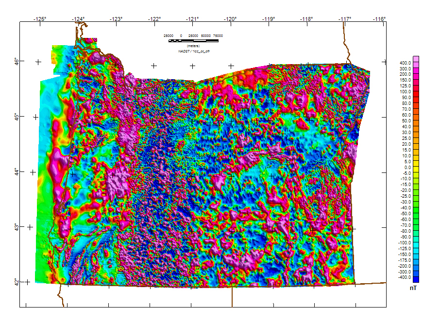
USGS has done "areomagnetic anomaly" surveys. These are conducted by planes flying at a set elevation above ground level. (old surveys were conducted at a set elevation based of sea level, but they aren't as accurate). These surveys produce a *different* sort of topological map

Image

To give you an idea of how accurate, and small most of these variations are. Magnetic field strength is measured in Tesla, where 1 Tesla = 1 Weber per square meter... Blah blah blah, we could dive deep into physics there trying to explain all that, but it would be boring to most.

The map above is measuring the anomaloes from the global field in nanoTesla, or nT. Earth's magnetic field itself at the surface is around 25-65 microTesla. 1,000nT = 1 µT

So in that map above it maxes out at less than .5 µT. Other than very localized and specific anomalies I don't think there will be any sort of significant deviation. Most places say that the earth's main field accounts for ~90% of the interaction on your compass needle. If you'd like a better map it's interesting, but weird to read) you can check out some fairly large PDF's over HERE1 and HERE2

These are laying out the field strengths like you would normally lay out topography, with 50nT intervals. Hachuer marks indicate negative values, as they would indicate 'depressions' on a normal topo map.

raven
Posts: 1531
Joined: May 28th, 2008, 10:03 pm

Re: Nav Work 104 - Let's Talk Maps!

Post by raven » August 19th, 2013, 12:55 pm

Magnetic anomalies are a practical problem for navigation around here. Once I was approaching a triple pass north of Willamette Pass after a long day of solo skiing with a need to get back to the ski area and my ride on a timely basis. As I took a reading on top to decide whether to ski off left or right, something bothered me about the heading. I skied back along my path about, noting a curve. I had been checking my compass regularly because I was skiing in a gray world of short-distance views. I continued down until I was in an area I where I had been skiing in a straight line. Extending that line I approached the summit from a different direction and do took a different valley for my descent. Along for the ride that day was a geology grad student who noted that a local map showed an up to 15 degree magnetic deviation near where I found the anomaly. My indications (the difference between the heading where I skied off and where I read the compass initially) were that the deviation was greater than 15 degrees.

In the days of Loran navigation, which was distorted by magnetic anomalies, one could fly over the lava watching ones speed change in spurts and the heading indicator deviate left and right. Elsewhere too, such as over the highway near Zigzag or powerlines.

So, are there any ground level compass deviation charts available? Field strengths may suffice for a physicist with a calculator, but it is hard to deal with at 4:15 PM on a day when the light is going to fail at 5:00 PM and there is a timely decision to make. Or a conversion program? My generic problem with aeromagnetic surveys is that they average ground readings over distances, muddying any use in navigation for walking-based travel in complicated terrain.
Last edited by raven on August 19th, 2013, 3:05 pm, edited 1 time in total.

Lurch
Posts: 1270
Joined: May 28th, 2008, 10:03 pm
Location: Aurora
Contact:

Re: Nav Work 104 - Let's Talk Maps!

Post by Lurch » August 19th, 2013, 2:17 pm

No doubt those anomalies are around here. I was merely saying that there are a lot of factors that will most often completely outweigh the local effects. You can go out to wyeth and set your compass on the ground and watch the need notably divert. If you want to be super accurate there are even measurable differences in declination based off the time of day. This is where knowing your environment and being able to navigate properly can come into play. At most that diversion should be noticeable, and make you pause to rethink what you're doing and how to compensate.

What you see to be looking for though, is an Isogonic Map of Oregon, if you find a newer one let me know, the best I can do for you right now is one from 1955 ;)
1955declination.png
At the time of that map, the author made an example of an area down in the Steens Mountains where they had documented declinations from as far as 5.7°W to 32.4°E. I'm still looking for a good map for this, but some early surveyors writings on the topic are definitely interesting.

As a side note, USGS has some 7,000+ "Magnetic Stations" in the US, 236 of those were in Oregon as of 1956. These would be marked by the normal benchmark brass plaque, with a star of david shape in the center. I'm working on digging up documentation on those to see if they're still active. Most were marked at the county seat, and are supposed to be re-surveyed every 5 years.

Lurch
Posts: 1270
Joined: May 28th, 2008, 10:03 pm
Location: Aurora
Contact:

Re: Nav Work 104 - Let's Talk Maps!

Post by Lurch » August 19th, 2013, 2:40 pm

If ya want to go back in time a little more ;) This would be an interesting one to actually plot out
1901 Declination.png

Post Reply