The Hillmap utility is a very nice piece of work. I have seen that the author has posted on Portland Hikers. The processing in Hillmap is much the same as what I do but the underlying data is still much lower resolution than LiDAR data. Also, LiDAR effectively removes trees because some part of most laser pulses will reach the ground. I'll find a place that illustrates this by showing old road grades that are normally invisible due to tree cover.have you played with the layer stacking in the Hillmap utility? You can stack different layers on each other adjusting their transparency, the CaltopoHillshade layer looks like lidar imagery...
Where to start discussions about cartography?
-
Adventure Mapper
- Posts: 70
- Joined: October 18th, 2012, 7:37 am
Re: Where to start discussions about cartography?

Re: Where to start discussions about cartography?
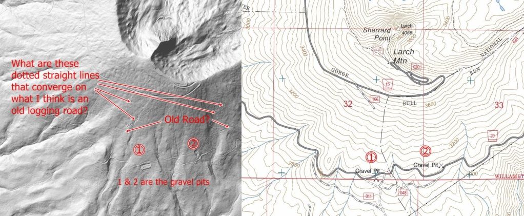
Lidar data is way cool. Here's an area of Larch Mt. that shows where there are old logging roads and strange divots in a straight line converging at the road. I'm guessing it has something to do with the method of moving the timber to the road.
Last edited by Peabody on October 19th, 2012, 7:20 pm, edited 2 times in total.
"I arise in the morning torn between a desire to improve the world and a desire to enjoy the world. This makes it hard to plan the day.”
― E.B. White
― E.B. White
-
Adventure Mapper
- Posts: 70
- Joined: October 18th, 2012, 7:37 am
Re: Where to start discussions about cartography?
It looks like folks are getting LiDAR data as hillshaded (sometimes called shaded relief) images that are not geo-referenced. There are ways to geo-reference the images but it is easier to put the data directly into a GIS program where it can be combined with other data such as GPS tracks, roads and streams.
Who do we talk to to get a place for this type of thread?
Who do we talk to to get a place for this type of thread?
-
Don Nelsen

- Posts: 4381
- Joined: May 28th, 2008, 10:03 pm
- Location: Vancouver, WA
Re: Where to start discussions about cartography?
Hi Peabody,
Those dots converge on a steam donkey site where timber was loaded onto rail cars. Parts of the steam engine chimney are still there in the woods. The dots are actually shallow pits now, two of them had water in them last fall. I'm not sure how a skid road came to be that way but I think it was some sort of high line system that caused the end of logs to dig into the dirt periodically as they were hauled down the slope. The "old logging road" was a steam era railroad grade. The one that heads to the left crossed the Larch Mt. Rd. at MP 12.6 and continues up the hill to a dead end. The one that goes to the right crosses trail 424 and then trail 444 is on top of it into the Larch crater. Neat that the lidar shows that detail so well. I've walked all of those lines and sure would have found them easier if lidar was available earlier!
Don
"Everything works in the planning stage" - Kelly
"If you don't do it this year, you will be one year older when you do" - Warren Miller
"If you don't do it this year, you will be one year older when you do" - Warren Miller
Re: Where to start discussions about cartography?
Don
I found this old 1920's movie online showing the high line and logs digging into the earth like you describe.
Link.
I found this old 1920's movie online showing the high line and logs digging into the earth like you describe.
Link.
"I arise in the morning torn between a desire to improve the world and a desire to enjoy the world. This makes it hard to plan the day.”
― E.B. White
― E.B. White
-
Eric Peterson

- Posts: 4097
- Joined: May 11th, 2009, 5:39 am
- Location: Oregon
- Contact:
Re: Where to start discussions about cartography?
I wonder way back when did they replant those clear cuts or just raise the forest and move on?
-
Adventure Mapper
- Posts: 70
- Joined: October 18th, 2012, 7:37 am
Re: Where to start discussions about cartography?
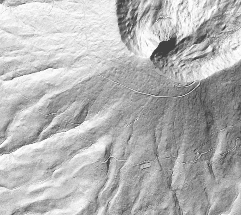
I've attached a "map" of the west slope of Larch Mtn. made from LiDAR data. It's a pretty high resolution image so you can zoom in to see detail.
Roads are orange/black and streams are blue. Roads and streams are Forest Service GIS data, probably hand digitized from aerial photos. They got the roads pretty close but the LiDAR shows the water courses better.
The elevation model is shown slope shaded rather than hillshaded. It's a subtle difference but the slope shade can bring out road cuts and fills more clearly in some cases. Horizontal resolution of the elevation data is only about 3 times better than the usual that is used for CalTopo and others but the way tree cover has been removed and the high vertical resolution indicates that it is LiDAR data.
The grid spacing is 500 meters.
My GPS tracks are overlaid in very faint purple. They follow an old logging RR grade as it splits off a road and heads roughly SE. There is an old camp along the way that includes some old batteries. The skid road runs straight E/W (W is down) just north of a grid line. It looks like there was some sort of bridge where it crosses the stream. Further west there is some really nice old equipment. It looks like another skid road runs down to the NW and joins just above the stream.
- Attachments
-
- This detail is made from LiDAR data (1/9 arc sec DEM).
-
- This map shows the location of the detailed map.
-
Don Nelsen
- Posts: 4381
- Joined: May 28th, 2008, 10:03 pm
- Location: Vancouver, WA
Re: Where to start discussions about cartography?
Thanks for the link!Peabody wrote:Don
I found this old 1920's movie online showing the high line and logs digging into the earth like you describe.
Link.
dn
"Everything works in the planning stage" - Kelly
"If you don't do it this year, you will be one year older when you do" - Warren Miller
"If you don't do it this year, you will be one year older when you do" - Warren Miller
-
Don Nelsen
- Posts: 4381
- Joined: May 28th, 2008, 10:03 pm
- Location: Vancouver, WA
Re: Where to start discussions about cartography?
Adventure Mapper wrote:I've attached a "map" of the west slope of Larch Mtn. made from LiDAR data. It's a pretty high resolution image so you can zoom in to see detail....
...There is an old camp along the way that includes some old batteries. The skid road runs straight E/W (W is down) just north of a grid line. It looks like there was some sort of bridge where it crosses the stream. Further west there is some really nice old equipment. It looks like another skid road runs down to the NW and joins just above the stream.
You've found what was was once known as "Camp A" on the mainline of the Logging RR. I can see some things on the lidar you posted that I have yet to explore. Is this lidar available on-line? dn
"Everything works in the planning stage" - Kelly
"If you don't do it this year, you will be one year older when you do" - Warren Miller
"If you don't do it this year, you will be one year older when you do" - Warren Miller
-
Adventure Mapper
- Posts: 70
- Joined: October 18th, 2012, 7:37 am
Re: Where to start discussions about cartography?
I think it was Roy Stout who took us in there first, either him or Bus Gibson.Don Nelsen wrote: You've found what was was once known as "Camp A" on the mainline of the Logging RR.
The LiDAR data is available on-line but you will need some sort of viewer to use it. What do you use now to view maps and overlay tracks? I might be able to convert the data you want.Don Nelsen wrote: Is this lidar available on-line? dn