Old School: Wallowa Mountain Loop - September 1982
Posted: March 13th, 2011, 5:50 pm
Here we go again! This time, yours truly is prominently featured in the photos... much to my horror! 
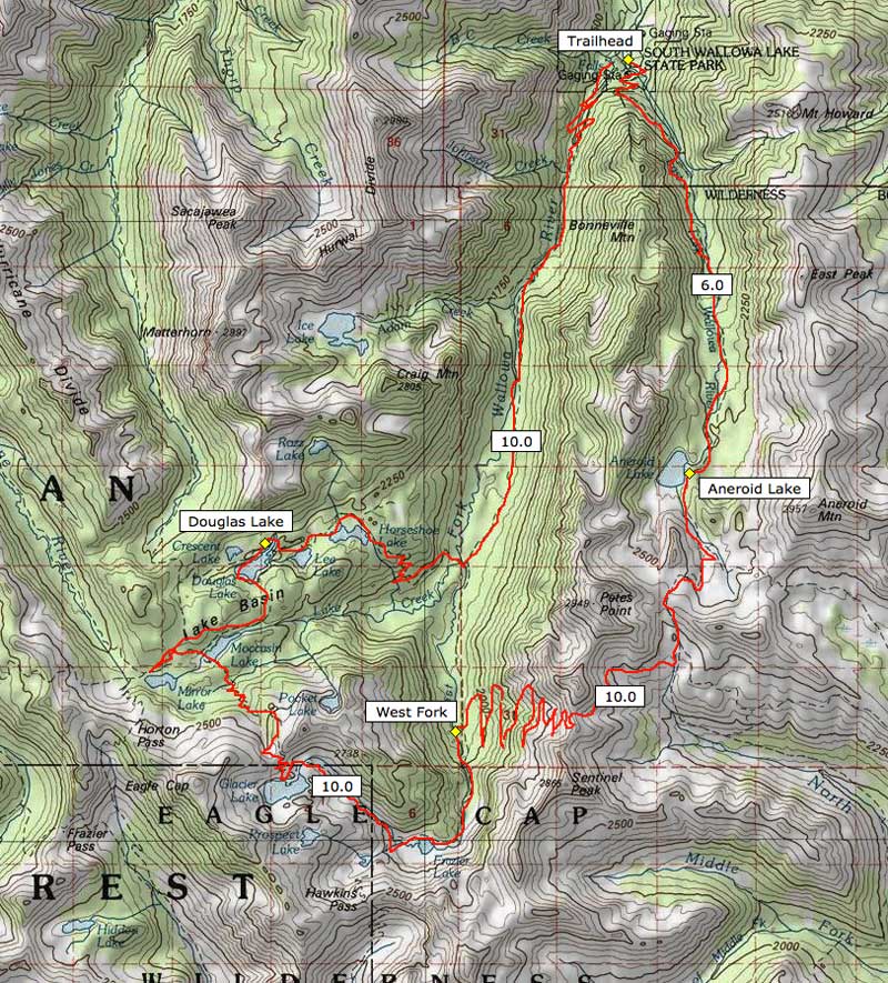
This was 3-day trip that I took with my Oregon State University friend Gary, in September 1982, about a week before fall term started. The loop went up past Aneroid Lake, over Polaris Pass, back up to Glacier Pass, then down through the Lakes Basin and the West Fork to the trailhead. I've posted a "modern" map at the bottom of the report to show the approximate route -- hope to do this again, someday, as I'll explain later...
So, we camped at the trailhead after a late arrival -- here, we're dividing up the groceries and gear for the trip. Note the highly nutritious Pop Tarts and Wheat Thins (more about those, in a moment, too...) that we'd grabbed in Joseph... I think I'm looking at cans of chili, and wondering why I didn't bring along freeze-dried (probably too broke), or worse... WHY I'd brought chili, since we were sharing my tent..!
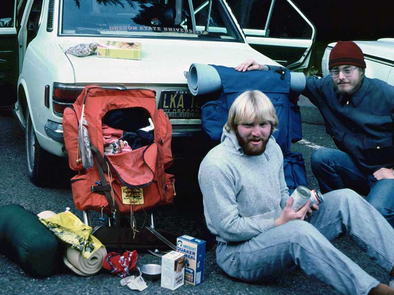
I'm pretty sure that's a bag of trail mix next to the Wheat Thins... and believe it or not, the yellow bag is a "carry your junk out" bag that the USFS provided at the trailhead -- along with a little plastic trowel for burying... well, you know...
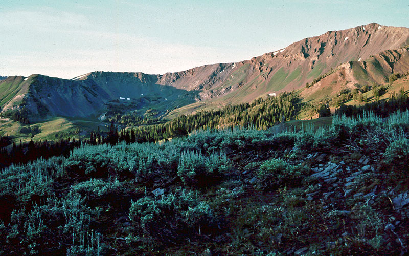
So, the first day we hiked up the East Fork, away from the crowds along the lower trail, past Aneroid Lake (and the last of the hikers), and to a lonely little tarn below Tenderfoot Pass. When we woke up the next day, Sentinel Peak was lit up across the upper meadows of the Imnaha River canyon complex:
From our campsite, the hike to Polaris Pass was relatively straightforward, as we'd done most of the climbing the first day... yet for some reason, I look like I've been run over by a herd of mountain goats! Maybe it was something I was carrying in my wineskin...
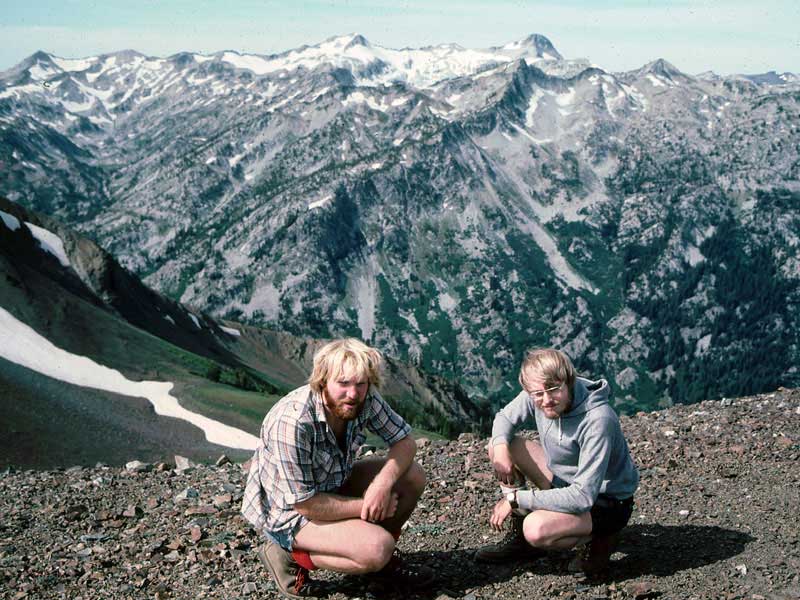
From Polaris Pass -- which I must say, remains my favorite vantage point in the Wallowas -- our route was painfully laid out before us: straight down through a long series of perfectly-graded (yet endless) switchbacks to the bottom of the West Fork canyon, and our second campsite, then over the shoulder of Eagle Cap to our third campsite (the tall peak directly above Gary in the above photo).
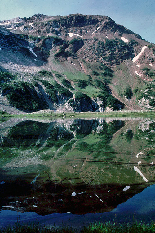
Our campsite along the West Fork was very peaceful -- sounds of the river all night. We got up early for the climb to Glacier Pass the next day, passing beautiful Frazier Lake in the morning sun, just above our still-shaded campsite:
From Frazier Lake, the West Fork trail becomes increasingly spectacular as you wind up the rocky, narrow canyon below Glacier Lake and Eagle Cap. Here's a bit of heartbreak from this trip, however -- this shot, including the well-travelled Wheat Thins box -- is the very last, as the next two rolls of film were exposed at the wrong ASA (what we used to call it before it was ISO), and came out impossibly overexposed:
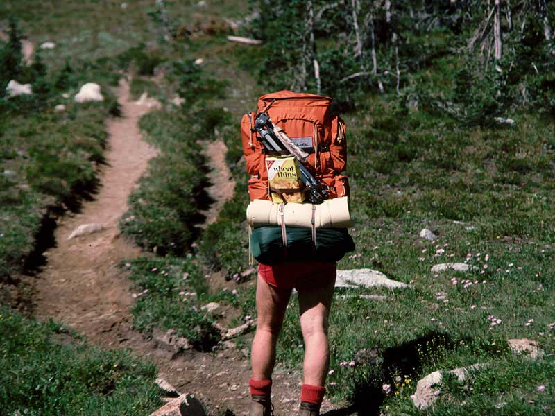
Note in addition to the Wheat Thins box, I was carrying a tripod! That's the real tragedy of the ruined images, as I had carefully set up some pano shots at Glacier Lake and Glacier Pass, then some nice sunset shots from Moccassin Lake that night. The worst part is that had I noticed I was shooting at the wrong speed, I could have had the slide developed accordingly, and they would have been fine... sigh...
Here's a map of the loop, and the "lost shots" are reason enough to do it again someday! It makes for a nice, compact loop that can fit into a mid-week window, thus avoiding weekend crowds. BTW, this is also the trip where we encountered "the naked man with a rifle" running through the forest... LONG after that wineskin was dry, too!
-Tom
This was 3-day trip that I took with my Oregon State University friend Gary, in September 1982, about a week before fall term started. The loop went up past Aneroid Lake, over Polaris Pass, back up to Glacier Pass, then down through the Lakes Basin and the West Fork to the trailhead. I've posted a "modern" map at the bottom of the report to show the approximate route -- hope to do this again, someday, as I'll explain later...
So, we camped at the trailhead after a late arrival -- here, we're dividing up the groceries and gear for the trip. Note the highly nutritious Pop Tarts and Wheat Thins (more about those, in a moment, too...) that we'd grabbed in Joseph... I think I'm looking at cans of chili, and wondering why I didn't bring along freeze-dried (probably too broke), or worse... WHY I'd brought chili, since we were sharing my tent..!
I'm pretty sure that's a bag of trail mix next to the Wheat Thins... and believe it or not, the yellow bag is a "carry your junk out" bag that the USFS provided at the trailhead -- along with a little plastic trowel for burying... well, you know...
So, the first day we hiked up the East Fork, away from the crowds along the lower trail, past Aneroid Lake (and the last of the hikers), and to a lonely little tarn below Tenderfoot Pass. When we woke up the next day, Sentinel Peak was lit up across the upper meadows of the Imnaha River canyon complex:
From our campsite, the hike to Polaris Pass was relatively straightforward, as we'd done most of the climbing the first day... yet for some reason, I look like I've been run over by a herd of mountain goats! Maybe it was something I was carrying in my wineskin...
From Polaris Pass -- which I must say, remains my favorite vantage point in the Wallowas -- our route was painfully laid out before us: straight down through a long series of perfectly-graded (yet endless) switchbacks to the bottom of the West Fork canyon, and our second campsite, then over the shoulder of Eagle Cap to our third campsite (the tall peak directly above Gary in the above photo).
Our campsite along the West Fork was very peaceful -- sounds of the river all night. We got up early for the climb to Glacier Pass the next day, passing beautiful Frazier Lake in the morning sun, just above our still-shaded campsite:
From Frazier Lake, the West Fork trail becomes increasingly spectacular as you wind up the rocky, narrow canyon below Glacier Lake and Eagle Cap. Here's a bit of heartbreak from this trip, however -- this shot, including the well-travelled Wheat Thins box -- is the very last, as the next two rolls of film were exposed at the wrong ASA (what we used to call it before it was ISO), and came out impossibly overexposed:
Note in addition to the Wheat Thins box, I was carrying a tripod! That's the real tragedy of the ruined images, as I had carefully set up some pano shots at Glacier Lake and Glacier Pass, then some nice sunset shots from Moccassin Lake that night. The worst part is that had I noticed I was shooting at the wrong speed, I could have had the slide developed accordingly, and they would have been fine... sigh...
Here's a map of the loop, and the "lost shots" are reason enough to do it again someday! It makes for a nice, compact loop that can fit into a mid-week window, thus avoiding weekend crowds. BTW, this is also the trip where we encountered "the naked man with a rifle" running through the forest... LONG after that wineskin was dry, too!
-Tom