This is a forum for trip reports that pre-date the Portland Hikers forum, trail photos from pre-digital era, or any other discussions that focus on trail history.
-
Splintercat
- Posts: 8334
- Joined: May 28th, 2008, 10:03 pm
- Location: Portland
-
Contact:
Post
by Splintercat » December 21st, 2010, 10:36 pm
This clip is from the same 1920s highway guide that includes the maps I posted in the Upper Bridal Veil thread. In this case, a "lost place" called Gardner's Point is described, and is clearly Sevenmile Hill:
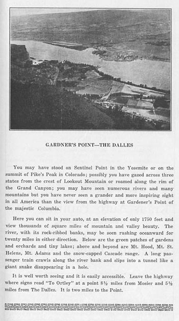
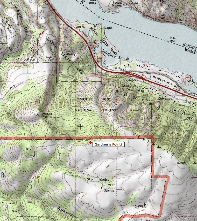
The question in my mind is where -- and one guess would be at the end of the dirt road shown leading out of Ortley. The elevation more or less matches that described in the old guide, and the photo seems to show this perspective of Rowena Crest, below. Here's the topo:
Anyone else heard of this before?
Tom
-
mattisnotfrench
- Posts: 1318
- Joined: May 28th, 2008, 10:03 pm
- Location: SE Portland
-
Contact:
Post
by mattisnotfrench » December 21st, 2010, 10:47 pm
I'm definitely going to check this out. I love that area. What exactly is Ortley? I mean, is it one of those "towns" with two houses and a barn? I see those all over the map in Oregon, such as Friend, near Dufur.
Author of
Extraordinary Oregon!,
PDX Hiking 365,
101 Hikes in the Majestic Mount Jefferson Region, and
Off the Beaten Trail. Website:
www.offthebeatentrailpdx.com
-
BrianEdwards
- Posts: 2405
- Joined: February 2nd, 2010, 1:32 am
- Location: Oregon City, OR
-
Contact:
Post
by BrianEdwards » December 22nd, 2010, 12:02 am
mattisnotfrench wrote:I see those all over the map in Oregon, such as Friend, near Dufur.
The town of Friend, OR used to be the terminus of a railroad line from The Dalles. Six years ago I traveled to Friend to try and find any remains of the line, but only found a modern house and a faint part of the grade in the 'town'. I've found that many of the randomly placed names on the Oregon map are by-gone railroad stations.
-
BigBear
- Posts: 1836
- Joined: October 1st, 2009, 11:54 am
Post
by BigBear » December 22nd, 2010, 10:10 am
I have not heard of Gardiners Point. It might be at the 2050' hill where the microwave tower is currently located. That would be about 1700 feet above the river, which might be the elevation refered to in the article. Also, the photo seems further east of Lyle than the point you marked on the map
Ortley is a ghost town. My wife and I tried to locate it a couple of springs back, but the roads were getting pretty rough for my car. The town is described in a circa 1975 Ghost Towns of Oregon book. The Dalles Info Center person said there was nothing left of the old town when we asked.
If you do want to see a ghost town in the Gorge, go to Sonny. This place is located on the Wygant-Chetwoot loop along the old highway. The rock foundations of a couple of buildings and the old logging flume are still visible. On the way back to your car at Lausman, you can partially make out the old wagon road leading back to the saddle between Mitchell Point and Little Mitchell. The cement foundation of the old stagecoach inn had been easy to locate near the trailhead until a mudslide came down the west side of Mitchell Point and buried the site. Haven't been back recently to see if erosion has brought it back to the surface.
Also from the old days is an apple orchard along the gravel road heading west from the top of Mitchell Point. It was at least a mile to the west and proabably a quarter mile east of the creek which the road crosses.
-
BigBear
- Posts: 1836
- Joined: October 1st, 2009, 11:54 am
Post
by BigBear » December 22nd, 2010, 10:11 am
Oh, an additional find is the chimney of a building just above I-84 along Pernham Creek. Came across that in the spring of 1996 when the official trailhead to Wygant Peak was closed and we had to make-do with some bush-whacking.
-
Stevefromdodge
- Posts: 2508
- Joined: May 28th, 2008, 10:03 pm
Post
by Stevefromdodge » December 22nd, 2010, 10:46 am
BigBear wrote:Oh, an additional find is the chimney of a building just above I-84 along Pernham Creek. Came across that in the spring of 1996 when the official trailhead to Wygant Peak was closed and we had to make-do with some bush-whacking.
There's an old Columbia River Highway marker in a bunch of rocks near Perham Creek. There's a picture of it at
http://www.oregon.gov/ODOT/HWY/HCRH/doc ... n_seg7.pdfIs that the same thing your thinking of?
-
Jane
- Posts: 3639
- Joined: May 28th, 2008, 10:03 pm
Post
by Jane » December 22nd, 2010, 12:33 pm
I did a hike in this area a couple years ago with a friend from Hood River. There were fringes of private lands we crossed, but he had connections with the locals.
Here is that archived trip report, I tried to find the original photos as the one in the tr did not come over well .
http://www.portlandhikers.org/archive/view/31841
...
these were posted hurridly and without exact recollction of correct order 
-
Stevefromdodge
- Posts: 2508
- Joined: May 28th, 2008, 10:03 pm
Post
by Stevefromdodge » December 22nd, 2010, 12:42 pm
Tom from the angle of the foreground ridge (that blocks part of the rail line), I would guess that Gardner's Point was a little farther east. My guess would be at the end of the ridge near the "S" in Seven Mile.
Looks like an interesting place.
-
BigBear
- Posts: 1836
- Joined: October 1st, 2009, 11:54 am
Post
by BigBear » December 22nd, 2010, 12:52 pm
Yes, StevefromDodge. The "chimney" looked like the park marker. We had all incorrectly assumed the rest of the foundation was buried by past mudflows. That looks like an interesting source of info you have come across.