Hi all,
I've only recently started posting here much, but I've been a lurker for awhile. I know there are a lot of you out there that are map hounds/junkies the same as me, especially when it comes to the historic side of the gorge, and lost trails and buildings.
So I have a present for you, a 1:124,000 scale 1911 USGS Topo map of 'Mount Hood and Vicinity'. I've overlayed it in Google Earth, and put it up online for ya. You may have to install the plugin to run the browser based GE, and give it a bit cause it has a lot to load and I don't have the fastest host. If it doesn't drop you onto it automatically just zoom into the gorge for the goodness.
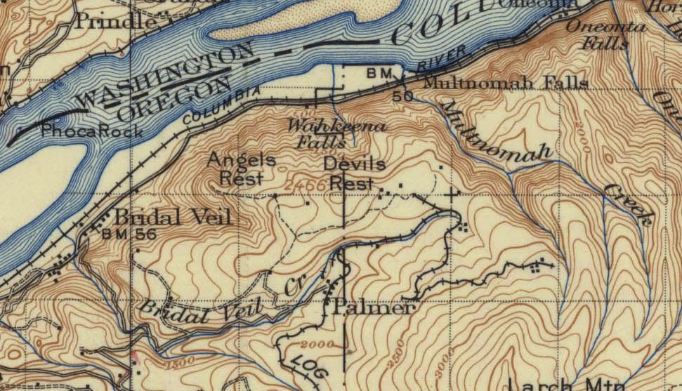
You can check it out HERE
If you just want the images, along with a couple other maps...
1911 Hood
1929 Hood River
1934 The Dalles
I'm working on getting some better print quality versions done, hopefully I'll have them soon.
Old Topo Maps...
Re: Old Topo Maps...
Interesting to see that they'd built a logging railroad almost to the top of Devil's Rest. It amazes me to think that some of those old "roads" we now use as trails could have railbed at one time.
- Splintercat
- Posts: 8333
- Joined: May 28th, 2008, 10:03 pm
- Location: Portland
- Contact:
Re: Old Topo Maps...
Fantastic, Lurch! These are nice, clean scans, too. I've got some old, similar versions but have only scanned chunks of them (or worse, photographed pieces). Fun to scroll around on these. Thanks for posting!
Tom
Tom
Re: Old Topo Maps...
I enjoy looking at old topo maps. There's a lot of history in both where things are and where things aren't. For example, on the 1911 map the Columbia Gorge is virtually trail-free. The Mazamas will not start their hiking program until April 1912 and that will be mainly along established roads. The CCC will not start building trails for two decades. On Hood's north side, the area will not open up for hiking until circa 1923 because there is a mis-belief that this side of the mountain fills Bull Run..
Re: Old Topo Maps...
Great maps, thanks for posting them. It is very timely as I am reading A River Lost and the maps help to understand what is now gone.
Bill
Bill
Re: Old Topo Maps...
Very informative maps, especially 1911 Hood map. It is interesting that on the 1911 map the butte above Cape Horn (east of Washougal WA) is called Mt. Zion - have never seen it on modern maps, was it renamed?
I was surprised that the area was so well researched, for example how did they map Eagle Creek which was virtually inaccessible without a trail (and no helicopters yet at that time)
- Eric Peterson
- Posts: 4097
- Joined: May 11th, 2009, 5:39 am
- Location: Oregon
- Contact:
Re: Old Topo Maps...
The Hood 1911 is the year?
Didn't know there was a Bonneville fish hatchery and such around the dam that wasn't built
into the 30's . . .
Didn't know there was a Bonneville fish hatchery and such around the dam that wasn't built
into the 30's . . .
Re: Old Topo Maps...
The hatchery was built in 1909 I believe
Re: Old Topo Maps...
This is an excellent resource and the oldest map I have yet to see. The details can be amazing!
Beaver Lakes below Sandy Glacier - long since buried by repeated glacial outwash events http://clackamas-outlook.blogspot.com/s ... el/Geology.
The pre-dam rapids of the Cascades of the Columbia - wish these went out to Celilo!
The old logging railroad grades generally are very gradual.
Here is a link to more Northwest old maps from 1921 to 1946 at Trail Advocates:
http://www.trailadvocate.org/?page_id=389
....where does that trail go?