Tom,
What a marvelous bit of sleuthing! - Thank you for this great info. Jamie and I were on a hike with cfm and others today and this story came up so I took a look at your post. I have wondered about this also. There was a turbine contraption used in the old days that was pretty good at generating electricity that might explain why such a steady and powerful head of water was needed. Here is a link to that device: http://en.wikipedia.org/wiki/Pelton_wheel There are rumors of one of these abandoned in the gorge but I have been unable to locate it.
-Don
Pipeline along the Upper McCord Trail
-
Don Nelsen

- Posts: 4380
- Joined: May 28th, 2008, 10:03 pm
- Location: Vancouver, WA
Re: Pipeline along the Upper McCord Trail
"Everything works in the planning stage" - Kelly
"If you don't do it this year, you will be one year older when you do" - Warren Miller
"If you don't do it this year, you will be one year older when you do" - Warren Miller

Re: Pipeline along the Upper McCord Trail
Very cool, would it be this one:Don Nelsen wrote:Tom,
Here is a link to that device: http://en.wikipedia.org/wiki/Pelton_wheel There are rumors of one of these abandoned in the gorge but I have been unable to locate it.
-Don
http://www.trailsclub.org/about_us/founding.html
......Before Lancaster assayed to have the glamour of Larch Mountain features in a big way, there was a well beaten trail from Oneonta, bypassing the gorge and leading past the Triple Fall up Oneonta Creek to a spot known as Bell Camp. Teuscher told this narrator that a small Pelton water wheel had been lugged up the Oneonta trail, hid in the brush and never installed. For aught he knew it might still be used as the object of a treasure hunt. That was thirty years ago. If it is still there and can be stumbled on to, it might be worth salvaging even yet. Why the persons who took it in never got around to installing it or bringing it out remains a mystery.
Now that would be cool find :^)..
-
Splintercat

- Posts: 8333
- Joined: May 28th, 2008, 10:03 pm
- Location: Portland
- Contact:
Re: Pipeline along the Upper McCord Trail
A most interesting theory, Bryan!Perhaps the dam breaking is what caused the now dry third channel of the upper falls to be plugged and dry up?
The Pelton Wheel explanation seems to make the most sense, given the processes involved in canning fish. But here's yet another twist this story, courtesy a 1996 Bonneville Power Administration report:
Another source reports that the Warrendale fish hatchery only functioned for a couple of years, and is mostly notable for being the first hatchery effort in the Gorge (in response to the collapsing fish runs at the time, presumably). So, another question is whether these pipes might have been used as originally theorized, but with the water used to maintain hatchery tanks or ponds..? (...and there's something ironic about breeding salmon fry inside a cannery..! Talk about cradle-to-grave operations..!)The hatchery program increased rapidly after 1888 and maintained high levels of production through the end of the period in 1920 (Figure 5). After turning the Clackamas Hatchery over to the U. S. Fish Commission, the State of Oregon built a hatchery in a cannery at Warrendale in 1889. Several hatcheries were built in the lower river, and in 1901, salmon from the Snake and Grande Ronde rivers were artificially propagated (Cobb 1930). In 1909 Oregon constructed Central Hatchery (later named Bonneville Hatchery) on Tanner Creek in the lower river. Central Hatchery had the capacity to handle 60,000,000 eggs and served as a central clearinghouse and incubation station for eggs collected throughout the region (Wallis 1964).
More tidbits for Don: some background on remnants of the Warrendale cannery activity on this site (that you've undoubtedly visited... but just in case):
Warrendale Hisotry
Cascades Townsite History
-Tom
Re: Pipeline along the Upper McCord Trail
Link from Friends of the Columbia River Gorge to Curious Gorge blog indicates pipe was for a pulp mill.
http://curiousgorgeblog.wordpress.com/10-2/
http://curiousgorgeblog.wordpress.com/10-2/
Re: Pipeline along the Upper McCord Trail
Thx for this post and link, that is really neat info, explains a lot, and great photos attached to the CG blog entry and I wonder what is left of that second pipe.kathyc wrote:Link from Friends of the Columbia River Gorge to Curious Gorge blog indicates pipe was for a pulp mill.
http://curiousgorgeblog.wordpress.com/10-2/
--Paul
The future's uncertain and the end is always near.

Re: Pipeline along the Upper McCord Trail
My favorite quote from that article:

Scott, is that your blog? If so good work digging up that info!
I measured the falls to be 213 feet tall, but my rangefinder generally has a margin of error of about +/-10 feet. So....vindication!In 1916 the United States geologic survey determined the height of the falls to be 221 feet.
Scott, is that your blog? If so good work digging up that info!
-
Splintercat
- Posts: 8333
- Joined: May 28th, 2008, 10:03 pm
- Location: Portland
- Contact:
Re: Pipeline along the Upper McCord Trail
Nice find, Scott! Terrific photos -- the smoking gun!
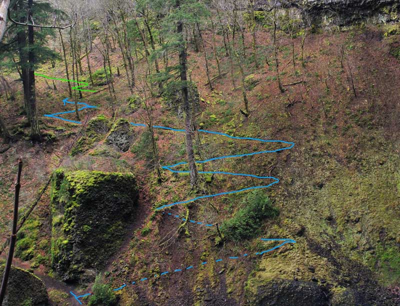
Interesting that the hike began on the east side of the creek, crossed, then climbed the switchbacks to the upper viewpoint. That makes so much more sense than the current Y-shaped format. It also helps explain the switchback traces you can see on the east side of the creek:
Great history!
Tom
Interesting that the hike began on the east side of the creek, crossed, then climbed the switchbacks to the upper viewpoint. That makes so much more sense than the current Y-shaped format. It also helps explain the switchback traces you can see on the east side of the creek:
Great history!
Tom
Re: Pipeline along the Upper McCord Trail
Tom, do you know anything about the history of or possible purpose of that rectangular construction your approximated switchbacks go past? I've never examined the stream looking for structures so I do not know what else might be nearby. Perhaps the block is part of an earlier low pressure water source/reservoir that proved inadequate, causing the building of the expensive pipeline.
-
Splintercat
- Posts: 8333
- Joined: May 28th, 2008, 10:03 pm
- Location: Portland
- Contact:
Re: Pipeline along the Upper McCord Trail
I'm not sure what you mean, Raven -- can you see it in the photo?
Tom
Tom
Re: Pipeline along the Upper McCord Trail
Yes. The dashed blue lines and the two blue-lined switchbacks immediately above them are directly to the right of -- actually are limited in the path they follow by -- what seems to be a stout rectangular solid stone or concrete object. Moss covered, a bit irregular due to erosion damage and possibly the removal of attachments, but it surely looks more to me like a piece of contraption than do many of Don's old railroad trestles.
Steve
Steve