Tom
Pipeline along the Upper McCord Trail
-
Splintercat

- Posts: 8333
- Joined: May 28th, 2008, 10:03 pm
- Location: Portland
- Contact:
Re: Pipeline along the Upper McCord Trail
Oh, THAT tiny object..!  I thought that was just a piece of fairly squarish basalt, but haven't looked at it that closely. In fact, I don't think I've ever walked more than a few feet beyond the bridge, for whatever reason, so not sure if there are traces of humanity over there.
Tom
Tom

Re: Pipeline along the Upper McCord Trail
There was a developed viewpoint on that rock at one time, some of the old fence posts and cable wire guardrail are still there. I'm pretty sure its a natural formation even though it looks oddly squared off on the corners. Really wouldn't have made much sense in there being any sort of building there because it's a good 50-70 feet above the creek and there isn't any evidence (or room) for flumes to have been run down from the east side of the falls to provide it with water.
-
Splintercat
- Posts: 8333
- Joined: May 28th, 2008, 10:03 pm
- Location: Portland
- Contact:
Re: Pipeline along the Upper McCord Trail
So, are you thinking it's the "viewpoint" mentioned in Scott's article, Bryan?
Tom
Tom
Re: Pipeline along the Upper McCord Trail
That's certainly a possibility, but not having gone past there to see what other relics might be found downstream, or followed the old trail tread, there could certainly be other locations where that original viewpoint could have been. If that was one of the original viewpoints, I find it a little odd that we haven't seen old pictures taken from it.
Re: Pipeline along the Upper McCord Trail
FYI -- on a foray up the Nesmith Ridge route awhile back I was wandering around the flatter "plateau" area at the base of the ridge and found a continuation of the old pipeline. It picks up atop the cliffs immediately above the trail switchbacks. A good piece of it was still remaining and it headed off in a general southeasterly direction. Assuming it meets up with the creek eventually, it'd intersect a fair distance above Upper Elowah (Upper McCord Creek) Falls. It was a good-sized pipe.
-
CuriousGorgeGuide

- Posts: 260
- Joined: March 28th, 2010, 10:48 am
Re: Pipeline along the Upper McCord Trail
Hey you Gorge guys...I just stumbled across this thread. I'm glad my blog has helped out some with this history, and if you check it again, you'll see the notation I made about Elowah's true height, with a shout out for Bryan's brilliant website. (Bryan, I just want to take the opportunity to thank you once again for your website and the exceptional due-diligence you display in pursuit of actual FACTS and historical accuracy!!)
Anyhow, I'll attach the pic here of the petrified log that once adorned the east side of the original McCord HCRH bridge (the one mention in the Oregonian article on my blog http://curiousgorgeblog.wordpress.com/10-2/ )
Maybe if i remember later toady, I'll take a photo of the pages of "Fishwheels of the Gorge" that deal with pioneer Myron Kelly...and post the pix here for all us history nerds to read.
Also, i want more info about this petrified stump...especially if it was removed and is now in front of the Sternwheeler Casc Locks office. hmmmm? Always another search in our lil wonderland, isn't there??
cheers, scott

Re: Pipeline along the Upper McCord Trail
I think it has always been just a pipeline. Here's a photo that I hadn't seen before:
http://www.gorgediscovery.org/photoarch ... le&ID=2386
http://www.gorgediscovery.org/photoarch ... le&ID=2386

Re: Pipeline along the Upper McCord Trail
Here's some more info from ODOT on the stump. If it is at the Sternwheeler office now, then it didn't start there!CuriousGorgeGuide wrote:Also, i want more info about this petrified stump...especially if it was removed and is now in front of the Sternwheeler Casc Locks office.
HCRH Trail - HCRH Trail Dedication Guided Tour - Site 10: Petrified Wood
"One vertical petrified tree, originally 10 feet tall, once stood in the road cut on the old Columbia River Highway just east of McCord Creek. The petrified tree became a tourist destination and tourists broke off pieces of the tree to bring home for souvenirs. In the 1930s, the Civillian Conservation Corps constructed a trail to Elowah Falls and placed a cage around the petrified to tree to protect it. During construction of I-84, the petrified tree was moved to Portland State University. During trail construction here in the switch back area, we encountered petrified wood during the rock slope excavation."
https://www.facebook.com/photo.php?fbid ... 772&type=1
Recreating The Historic Columbia River Highway:http://www.recreatingthehcrh.org/

Re: Pipeline along the Upper McCord Trail
Interesting semi-engineering exchange here! Can't add much to it except to say that at either the Washington Bonneville Dam fish viewing room or the Skamania Museum, has I believe that same picture, with some details about the pipe and it's usage. Wish I could recall what the details were, but there's just a big blank up in thought bubble! 
Kelly
There is no shortcut to anyplace worth going to.
PM me about the soon to be released:
Skamania 231
"How to really get off the beaten path in Skamania County"
There is no shortcut to anyplace worth going to.
PM me about the soon to be released:
Skamania 231
"How to really get off the beaten path in Skamania County"
-
Splintercat
- Posts: 8333
- Joined: May 28th, 2008, 10:03 pm
- Location: Portland
- Contact:
Re: Pipeline along the Upper McCord Trail
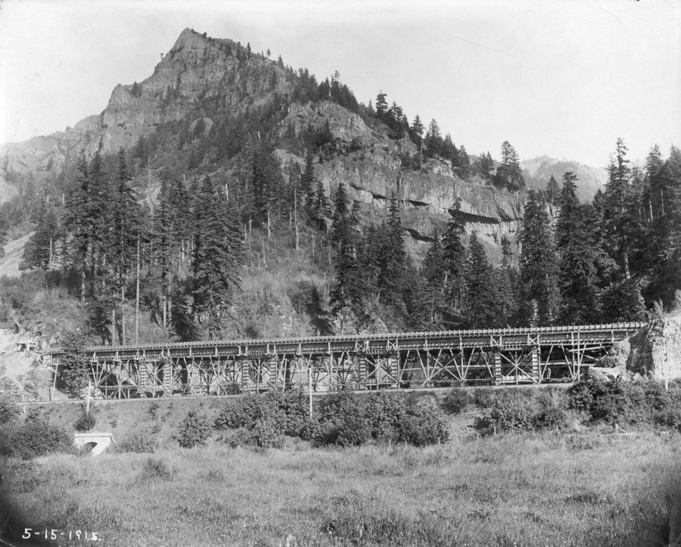
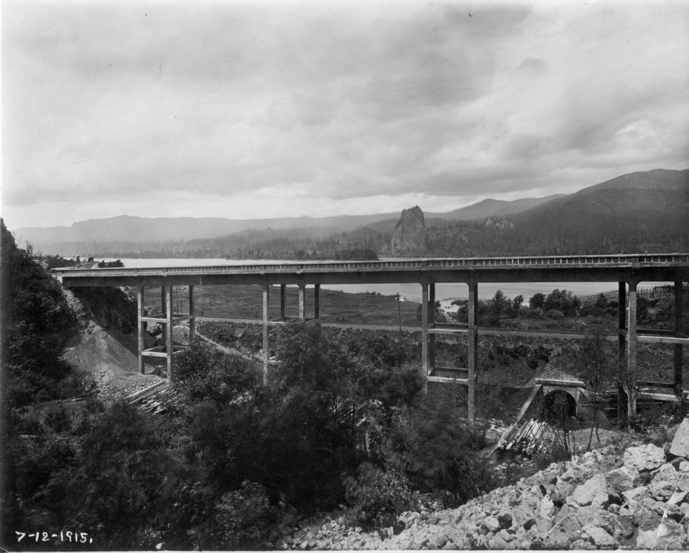
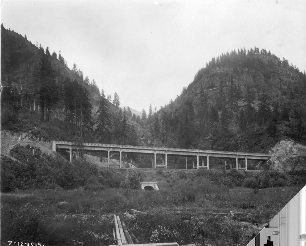
As part of dedicating the new HCRH State Trail bridge over McCord Creek (and it IS a beauty!), ODOT has released the following construction photos of the original highway bridge taken in 1915 -- with some great peeks at the surrounding terrain.
You can see the cut slope on the east end, where the petrified tree was located -- plus, a very nice view of Wauneka Point:
The scaffolding was still on in the May 1915 view, but by June, it was off -- this view from the east side of McCord looking across to Beacon Rock, with fishwheels on the far right, visible between the bridge uprights:
And finally, a July 1915 view that shows the pipeline where the Upper McCord trail is now located - plus, answers the question of how well Elowah Falls could be viewed from the bridge:
Must have been a glorious ride across back in the day -- sadly, most rush by in the modern era at 70 mph, hardly noticing what they are passing (and dodging triple trailers).
Looking forward to more ODOT photos rolling out as the Shellrock Mountain and Mitchell Point phases of the state trail get underway!
Tom