This is a forum for trip reports that pre-date the Portland Hikers forum, trail photos from pre-digital era, or any other discussions that focus on trail history.
-
Splintercat
- Posts: 8333
- Joined: May 28th, 2008, 10:03 pm
- Location: Portland
-
Contact:
Post
by Splintercat » February 13th, 2015, 8:25 pm
I found this image in a USFS historical archive awhile back -- labeled "CCC Trail Building in the Gifford Pinchot National Forest":
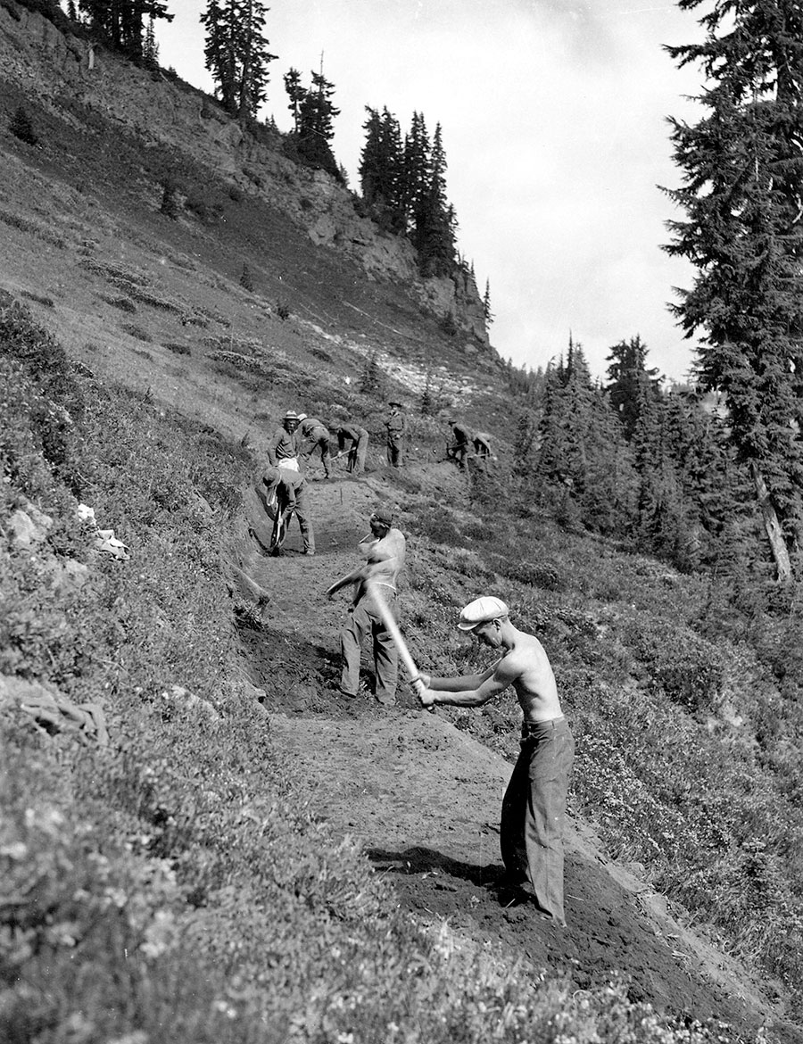
I've since used it on the TKO website and for all manner of retro-trail building stuff, as it's one of the few examples out there of a CCC crew building a trail in our part of the country! That said, I'm wondering if anyone recognizes this spot -- clearly alpine in a little cirque valley, so if it's in the GP, places like Goat Rocks and Mount Adams come to mind... anyone recognize this spot?
Tom
-
-Q-
- Posts: 1433
- Joined: July 5th, 2008, 10:42 pm
Post
by -Q- » February 13th, 2015, 8:40 pm
My money is on Mt Adams... Somewhere on the Round the Mountain Trail between Riley Camp Trail and Bird Creek Meadows
-
Lumpy
- Posts: 809
- Joined: October 8th, 2012, 9:26 am
Post
by Lumpy » February 13th, 2015, 9:01 pm
It might be hard to place that photo as I am fairly certain that there have been enough changes in any one place like that to make it hard to locate from one photo like that one. More trees could have grown, more hillside could have eroded away, the trail could have been relocated, detoured, or abandoned.
I did trail and salmon restoration work with the California Conservation Corps in Trinity County back in 1989-90. I want to go back to the places I worked to see the changes. I wonder if any of the SRP work is even still in existence? Nature could have just swept it all away long ago, changed the course of the run of the water, etc.
"Why are you always chasing women?"
"I'll tell you as soon as I catch one!"
-
retired jerry
- Posts: 14417
- Joined: May 28th, 2008, 10:03 pm
Post
by retired jerry » February 13th, 2015, 9:08 pm
reminds me of PCT South of Adams Creek, like where the Lewis River crosses PCT
-
Splintercat
- Posts: 8333
- Joined: May 28th, 2008, 10:03 pm
- Location: Portland
-
Contact:
Post
by Splintercat » February 13th, 2015, 10:14 pm
It's hard to say whether this slope is still open, but the tree here are mature mountain hemlock and the steep meadow is definitely alpine species (some heather in there), so what came to mind for me are the open slopes that form the west wall of Elk Cove -- where a combination of deep snow drifts and late snow melt have kept the treeline at bay. That's why I'm thinking Adams or Goat Rocks...?
The photo is definitely from the 1930s, and the trail is surprisingly wide -- so it was a recreation trail, not just a way trail for USFS operations. That could be an early version of the Skyline Trail (I don't remember what it was called in WA), as Jerry suggests -- but it could also be somewhere near Rainier, but just outside the NP boundaries.
Hmmm....
-
BigBear
- Posts: 1836
- Joined: October 1st, 2009, 11:54 am
Post
by BigBear » February 24th, 2015, 12:47 pm
A number of places on the trail come to mind, but my guess is Naches Peak near Rainier.
-
Gweedo
- Posts: 11
- Joined: August 14th, 2008, 4:16 pm
Post
by Gweedo » February 24th, 2015, 2:40 pm
Your picture reminded me of the hike up to Tatoosh Peak. Though in comparing the picture below the rocks that make up the top of the ridge are not the same. And the width of the trail has leaned out quite a bit. There's another section of ridge the trail goes along just before where this picture was taken, can't quite remember what the ridge looked like there to rule it out.
-
Attachments
-
 Viewed 5268 times")
-
Splintercat
- Posts: 8333
- Joined: May 28th, 2008, 10:03 pm
- Location: Portland
-
Contact:
Post
by Splintercat » February 25th, 2015, 8:38 pm
That's a pretty good match, though -- I think that could be it (add in 75 years of forest growth, of course). Thanks for posting!
Tom

-
Charley
- Posts: 1838
- Joined: May 28th, 2008, 10:03 pm
- Location: Milwaukie
Post
by Charley » February 26th, 2015, 7:47 am
Gweedo wrote:Your picture reminded me of the hike up to Tatoosh Peak. Though in comparing the picture below the rocks that make up the top of the ridge are not the same. And the width of the trail has leaned out quite a bit. There's another section of ridge the trail goes along just before where this picture was taken, can't quite remember what the ridge looked like there to rule it out.
I want to go THERE!
Believe it or not, I barely ever ride a mountain bike.


