Tom
PCT at Herman Creek
-
Splintercat

- Posts: 8333
- Joined: May 28th, 2008, 10:03 pm
- Location: Portland
- Contact:
Re: PCT at Herman Creek
Eric, that map also shows the PCT following the modern alignment from BP, but then crossing Herman Creek to terminate at the campground (and the roads to the CG make no sense to me on that map - nor the location of the CG, but that's probably just a scale/generalization issue). This is pure speculation, but one explanation for the missing bridge could be that it was a steel truss structure that was lifted from its previous location and moved to the current Trail 400 crossing -- or perhaps elsewhere in the Gorge. I don't know the story of the steel truss bridges in the Gorge, but there were clearly a bunch added at some point, perhaps the 1960s? I don't think they could have gotten the materials to the various sites (along Eagle Creek, Multnomah Creek, Oneonta Creek, etc) without a helicopter. So... just a theory..! 
Tom
Tom
-
Splintercat
- Posts: 8333
- Joined: May 28th, 2008, 10:03 pm
- Location: Portland
- Contact:
Re: PCT at Herman Creek
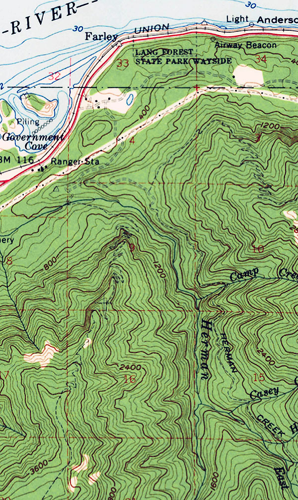
BTW, this is a clip from a 1957 topo map of the area -- shows a very different approach to the trails in the area from logging spurs that originated east of the current campground:
-Tom
-Tom
-
Eric Peterson

- Posts: 4097
- Joined: May 11th, 2009, 5:39 am
- Location: Oregon
- Contact:
Re: PCT at Herman Creek
Hey Tom, nice theory on the steel truss bridges, but I have a feeling the one crossing Herman Creek is
the original location. The trail that bombs off the BP used to nose dive down ridge towards the current
bridge location.
I guess they abandoned that ridge bomb when the PCT was re routed to trail that avoided the Forest Lane
road walk over to Cascade Locks?
Been on my to do list forever to cross the Herman Creek bridge and head OT up the ridge to try and find
any remnants of tread in my red circle above
the original location. The trail that bombs off the BP used to nose dive down ridge towards the current
bridge location.
I guess they abandoned that ridge bomb when the PCT was re routed to trail that avoided the Forest Lane
road walk over to Cascade Locks?
any remnants of tread in my red circle above
-
Don Nelsen

- Posts: 4380
- Joined: May 28th, 2008, 10:03 pm
- Location: Vancouver, WA
Re: PCT at Herman Creek
Hey Paislee, look what you started!
Tom,
You've got me really interested in heading back up there - you too, Eric.
In looking over my current mapset of the area, lots of disagreement with the old maps. On the old maps, not only is the PCT shown diving off the ridge but another trail is shown switch backing up to the Nick Eaton Ridge. Time for an expedition.
"Everything works in the planning stage" - Kelly
"If you don't do it this year, you will be one year older when you do" - Warren Miller
"If you don't do it this year, you will be one year older when you do" - Warren Miller
-
payslee
Re: PCT at Herman Creek
At least for once I'm not causing trouble 
I love learning all the old routes, especially in this area, since, as Viewfinder mentioned, Nick Eaton Ridge is marked on the oldest maps as "old Indian trail to Lost Lake". And it always amazes me just how ephemeral some of our traces in the woods can be, even after just 50 years.
Happy hunting! And if you happen to wait for longer days and better weather, let me know when you're heading out.
-payslee
-
payslee
Re: PCT at Herman Creek
and because old maps are the funnest maps, here's a clip from the 1897 BLM survey showing trails up Nick Eaton, "Benson's trail" to the Plateau, and a Herman Creek-level trail going up as far as Camp Creek.
Sorry for the poor image quality - the original is like 25 MB. Click to enlarge, or better yet, download the original from BLM for excellent zoom quality.
They've got the Herman Camp spring labeled "bear spring" (and yes, Jerry, there really is a spring there )
Looks like the Herman Creek Crossing back then was all the way west in Section 8, well downstream from the current footbridge.
-payslee
Sorry for the poor image quality - the original is like 25 MB. Click to enlarge, or better yet, download the original from BLM for excellent zoom quality.
Looks like the Herman Creek Crossing back then was all the way west in Section 8, well downstream from the current footbridge.
-payslee
-
Eric Peterson
- Posts: 4097
- Joined: May 11th, 2009, 5:39 am
- Location: Oregon
- Contact:
Re: PCT at Herman Creek
Thinking more about those steel truss bridges, shouldn't there be a 'born on date' somewhere?
Next time I cross one, I'll take a closer look
Next time I cross one, I'll take a closer look
Re: PCT at Herman Creek
1. I believe the map fragment Don posts from the 1959 Mt Hood Nat'l Forest map showing the Skyline along the west fork Herman Creek is either an error or just poorly drawn or both. In fact, all trails on this particular map are crudely drawn and most trails that appear in MHNF maps before and after this 1959 map are not to be found. There may be some historical interest in this map but as a trail guide not so much.
2. There is ample evidence in historical maps (other than the 1959 map) to support an alignment of the Skyline Trail along the East Fork of Herman Creek. I think a little digging around in the archives of the MHNF, Mazamas and Trails Club would find more supporting evidence. I was able to locate a boots on the ground letter to the editor of the Oregonian written in 1952 that supports the Skyline along the East fork of Herman Creek.
3. The alignment of the Nick Eaton trail as shown on USGS 24k topo maps is just flat wrong. The alignment on the 1956 62.5K maps is even worse. See hikes 21 (Skyline/PCT) and 22 (Nick Eaton) from the Lowes' 100 hikes for what stuff looked like in 1969 and descriptions of the departure from the work camp. The bridge across Herman Creek was in place by then.
Skyline along East Fork Herman Creek:
The 1938 map has all three trails of interest, the future Pacific Crest Trail along the Benson Plateau, the lesser standard trail along the west fork Herman Creek and the the present-day Herman Creek Trail. Note the markings for phone line on east fork Herman Creek - you can still find a couple of insulators along Herman Creek trail. The trail on the east fork of Herman Creek has always been a major route. And of course, it is labeled 'Skyline Trail'.
The 1952 map shows little change but in the Oregonian archives for 1952 I located a letter to the editor of the Oregon published May 11, 1952 by a C.M.Hamill wherein Mr. Hamill does what is so timeless around here, complain about the state of trails in the Gorge. Specifically the trail along the west fork Herman Creek and another trail what would become part of the PCT. I'll skip the snippet from the 1952 map, looks much like the '38.
This first snippet from Mr. Hamill's letter complains about the unbridged crossing of Herman Creek to get to what he refers to as the Dry Creek Trail and going on up to Tea Kettle Spring and the Benson Plateau.
This snippet from the Hamill letter regards the Skyline/east fork Herman Creek trail and west fork Herman Creek trail.
So boots on the ground support the Skyline along the east fork, trail on the west fork, and the future PCT going up to the Benson.
Here is the 1961 Skyline Map with the more familiar alignment - looks like there could be a bridge across Herman Creek. Note the 404 trail out of Eagle Creek - this would appear to follow Sorenson Creek - I'd be surprised if this trail actually ever existed - I've never seen it anywhere else. The ridge to the south of Sorenson Creek is pretty nice and could have had a way trail there. The 406 along the west fork does not go through - sort of my experience the couple of times I went out that way - Ha!.
My 2 cents.
2. There is ample evidence in historical maps (other than the 1959 map) to support an alignment of the Skyline Trail along the East Fork of Herman Creek. I think a little digging around in the archives of the MHNF, Mazamas and Trails Club would find more supporting evidence. I was able to locate a boots on the ground letter to the editor of the Oregonian written in 1952 that supports the Skyline along the East fork of Herman Creek.
3. The alignment of the Nick Eaton trail as shown on USGS 24k topo maps is just flat wrong. The alignment on the 1956 62.5K maps is even worse. See hikes 21 (Skyline/PCT) and 22 (Nick Eaton) from the Lowes' 100 hikes for what stuff looked like in 1969 and descriptions of the departure from the work camp. The bridge across Herman Creek was in place by then.
Skyline along East Fork Herman Creek:
The 1938 map has all three trails of interest, the future Pacific Crest Trail along the Benson Plateau, the lesser standard trail along the west fork Herman Creek and the the present-day Herman Creek Trail. Note the markings for phone line on east fork Herman Creek - you can still find a couple of insulators along Herman Creek trail. The trail on the east fork of Herman Creek has always been a major route. And of course, it is labeled 'Skyline Trail'.
This first snippet from Mr. Hamill's letter complains about the unbridged crossing of Herman Creek to get to what he refers to as the Dry Creek Trail and going on up to Tea Kettle Spring and the Benson Plateau.
- OArt02.jpg (45.36 KiB) Viewed 3534 times
Here is the 1961 Skyline Map with the more familiar alignment - looks like there could be a bridge across Herman Creek. Note the 404 trail out of Eagle Creek - this would appear to follow Sorenson Creek - I'd be surprised if this trail actually ever existed - I've never seen it anywhere else. The ridge to the south of Sorenson Creek is pretty nice and could have had a way trail there. The 406 along the west fork does not go through - sort of my experience the couple of times I went out that way - Ha!.
The future's uncertain and the end is always near.
-
Eric Peterson
- Posts: 4097
- Joined: May 11th, 2009, 5:39 am
- Location: Oregon
- Contact:
Re: PCT at Herman Creek
Great research Pablo!
Are those map snippets from your physical collection or available online somewhere?
Edit -
Or from http://www.trailadvocate.org/historical ... ine-trail/ ?
Are those map snippets from your physical collection or available online somewhere?
Edit -
Or from http://www.trailadvocate.org/historical ... ine-trail/ ?
-
northridge
- Posts: 73
- Joined: January 24th, 2010, 8:59 am
Re: PCT at Herman Creek
I second the comment regarding the research. Fascinating stuff.
Here is one way to get copies of the maps Pablo references: Look over his trip reports for mentions of lost gear. Go find the gear and return it to him. He will be grateful and will provide you with scans of the maps. It worked for me. (Thanks Pablo, I really appreciate the gesture).
VERY cool to see the possible 404 designation for a route off of EG. I have wondered about that one.