1934 Oak Grove Fork View

This is a forum for trip reports that pre-date the Portland Hikers forum, trail photos from pre-digital era, or any other discussions that focus on trail history.
Post Reply
User avatar
Splintercat
Posts: 8334
Joined: May 28th, 2008, 10:03 pm
Location: Portland
Contact:

1934 Oak Grove Fork View

Post by Splintercat » March 11th, 2013, 10:05 am

Ran across this view of the Oak Grove Fork from the Oak Grove Butte LO, taken in 1934:

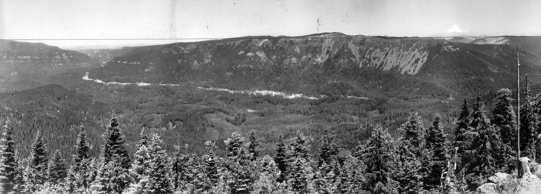
Click for Large Photo (1800 px)

Some familiar features: Mount Hood and Mount Mitchell. But I was curious about the wide swath of cleared ground along the Oak Grove Fork. Is this the original powerline/road/aquaduct corridor associated with Three Lynx/Oak Grove? I don't think the Oak Grove Fork is (was) volatile enough to disrupt the floodplain to that extent -- e.g., not a glacial stream, not an especially huge watershed compared to the main stem Clackamas.

Also liked the band of cliffs showing up so nicely along the NE flank of the Fish Creek Divide (on the far left) -- cliffs that Pablo has scaled and whose waterfalls Brian has explored. Some still show, but the forest has grown a lot over the past 80 years..!

Tom :)

User avatar
BrianEdwards
Posts: 2405
Joined: February 2nd, 2010, 1:32 am
Location: Oregon City, OR
Contact:

Re: 1934 Oak Grove Fork View

Post by BrianEdwards » March 11th, 2013, 2:08 pm

Being that the dam at Harriet was complete in 1923, is this just the clearing for the big pipe installation to the Oak Grove hydro Project? Maybe things were still fresh at that point from the construction. I bet you already considered that though :) Its on the correct side of the river for the pipe.
Clackamas River Waterfall Project - 95 Documented, 18 to go.

User avatar
BrianEdwards
Posts: 2405
Joined: February 2nd, 2010, 1:32 am
Location: Oregon City, OR
Contact:

Re: 1934 Oak Grove Fork View

Post by BrianEdwards » March 11th, 2013, 2:20 pm

The line of the clearing matches up well with the line of the Pipe. The Clearing is definitely up the hill, especially further downstream by the big bend.

I highlighted the pipe

Image

The river stays in a relatively straight line, if anything bending to the left slightly. I don't think the railroad line to the dam required such a clearing.
Clackamas River Waterfall Project - 95 Documented, 18 to go.

User avatar
Splintercat
Posts: 8334
Joined: May 28th, 2008, 10:03 pm
Location: Portland
Contact:

Re: 1934 Oak Grove Fork View

Post by Splintercat » March 11th, 2013, 9:13 pm

That makes sense, Brian - I was just surprised at the size of the clearing! Looks more like a powerline corridor, but I suppose they were moving a lot of equipment (and workers) around when they were building the pipeline, so needed the space. Amazing!

Tom

Post Reply