Page 1 of 2
1939 Mount Hood Map
Posted: March 2nd, 2013, 10:54 pm
by justpeachy
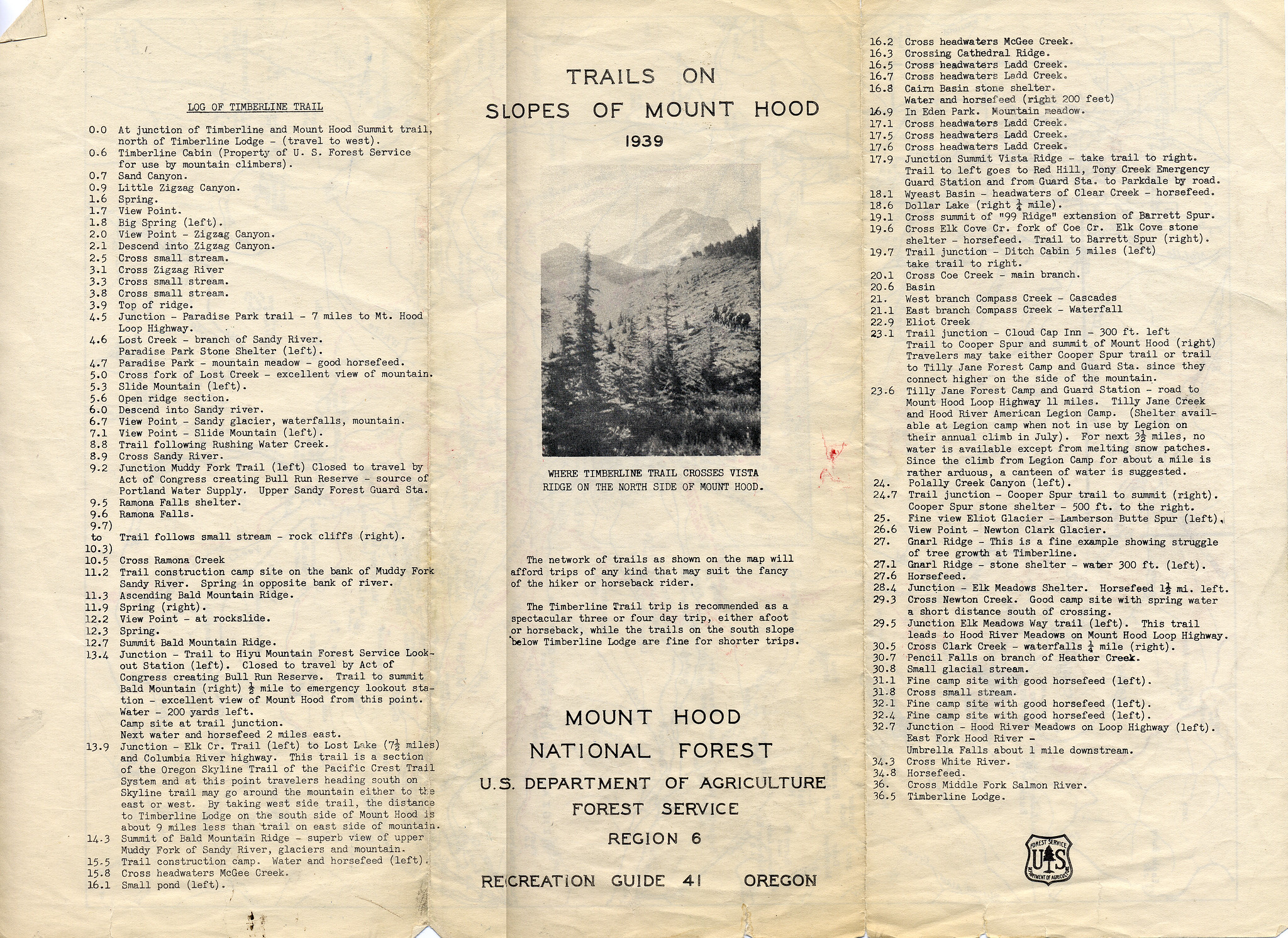
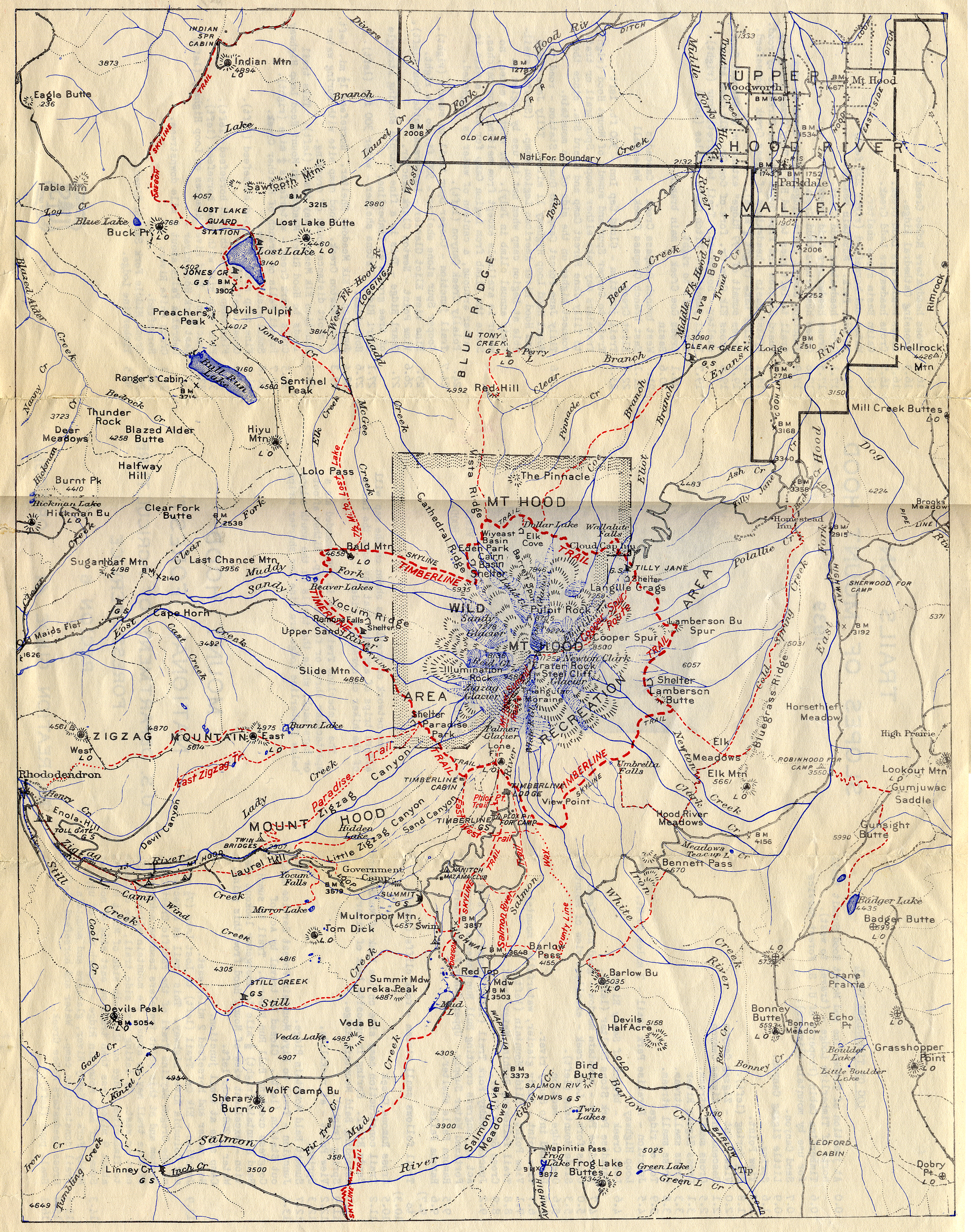
I came across this old brochure called "Trails on the Slopes of Mount Hood" from 1939. It has a map of the Mount Hood area and a list of landmarks along the Timberline Trail. If you're a map geek or history nerd the map is especially fun to study!

Re: 1939 Mount Hood Map
Posted: March 2nd, 2013, 11:31 pm
by raven
Wonderful find. A lot of lost trails on that map that I don't remember seeing on other maps. Of course, some of them will be hard to even imagineer due to fires, roads and clearcuts.
Re: 1939 Mount Hood Map
Posted: March 3rd, 2013, 7:36 am
by retired jerry
Interesting, thanks
Regarding Timberline trail, there was no Yocum Ridge trail or upper Muddy Fork crossing then
It says there's water 500 feet to the left (downhill) from Gnarl Ridge shelter but I've tried and failed to find that. I'll have to go look again

and it says 36.5 miles. maybe 39.5 miles now. The Eliot crossing is a little longer now. Maybe modern GPSes are more accurate
Re: 1939 Mount Hood Map
Posted: March 3rd, 2013, 9:25 am
by Chase
The 36.5 mileage number was accurate; the trail has changed course. The Muddy Fork bit of the late 70's/early 80's actually made the trail a little longer. But the bigger change was a sizable re-route in the Mt. Hood Meadows area (date unknown) which also lengthened the trail. I'm sure Splinty has more specifics on how the length of the trail changed over the years.
Interestingly, one of the two the men who initially measured the trail using a cyclometer were reported to be suspicious and it made the news:
"Crazy Man" Reported
HOOD RIVER, OR., Oct. 19.- (Special).-Members of the Timberline trail crews on Mount Hood a few days ago reported that they had seen, at a distance, a "crazy" man, pushing a bicycle wheel at the end of a stick along the new trail...
Oregonian, October 20, 1934, page 6
Thanks for the high-quality map, justpeachy.
Re: 1939 Mount Hood Map
Posted: March 3rd, 2013, 9:39 am
by kepPNW
What a wonderful map! I love that old-style cartography. It's what we were still doing up through the early 80s, with perhaps a bit less hand-lettering. One of the last artisan practitioners (Phil Arnold) only died a year or so ago. It's so rare to see it done with a multi-color press run, though! Clearly, that was some "big budget" stuff, there! The contrast of typewritten copy on the flipside is just too quaint (said in a good way
).
Thanks for posting those!
Re: 1939 Mount Hood Map
Posted: March 3rd, 2013, 12:58 pm
by Grannyhiker
What a treasure! When I have time, I'm going to enlarge it and go over it in detail. I wonder if there is any chance of resurrecting the trails that have disappeared....
Re: 1939 Mount Hood Map
Posted: March 3rd, 2013, 6:13 pm
by Splintercat
Thanks for the nice, big scan, Cheryl!
If you're a map geek or history nerd the map is especially fun to study!
Wait... I have to CHOOSE..? I'm basically a nerdy historic map geek, after all...
Tom

Re: 1939 Mount Hood Map
Posted: March 4th, 2013, 11:00 pm
by mjirving
Pretty cool! I was studying it and looking for Laurence Lake as a reference on the north side but couldn't find it. Then I realized it didn't exist back then as it is a dammed lake!
Re: 1939 Mount Hood Map
Posted: March 5th, 2013, 7:19 am
by Eric Peterson
Karl, can you geotag this?

I'm definitely a nerdy map geek too, thanks Cheryl!
Re: 1939 Mount Hood Map
Posted: March 5th, 2013, 7:28 am
by kepPNW
Eric Peterson wrote:Karl, can you geotag this?
I'm definitely a nerdy map geek too, thanks Cheryl!
Cool thought! Might have to look at that!