Page 1 of 2
1923 Map of Hood River Valley: I need your help!
Posted: February 10th, 2013, 4:34 pm
by Splintercat
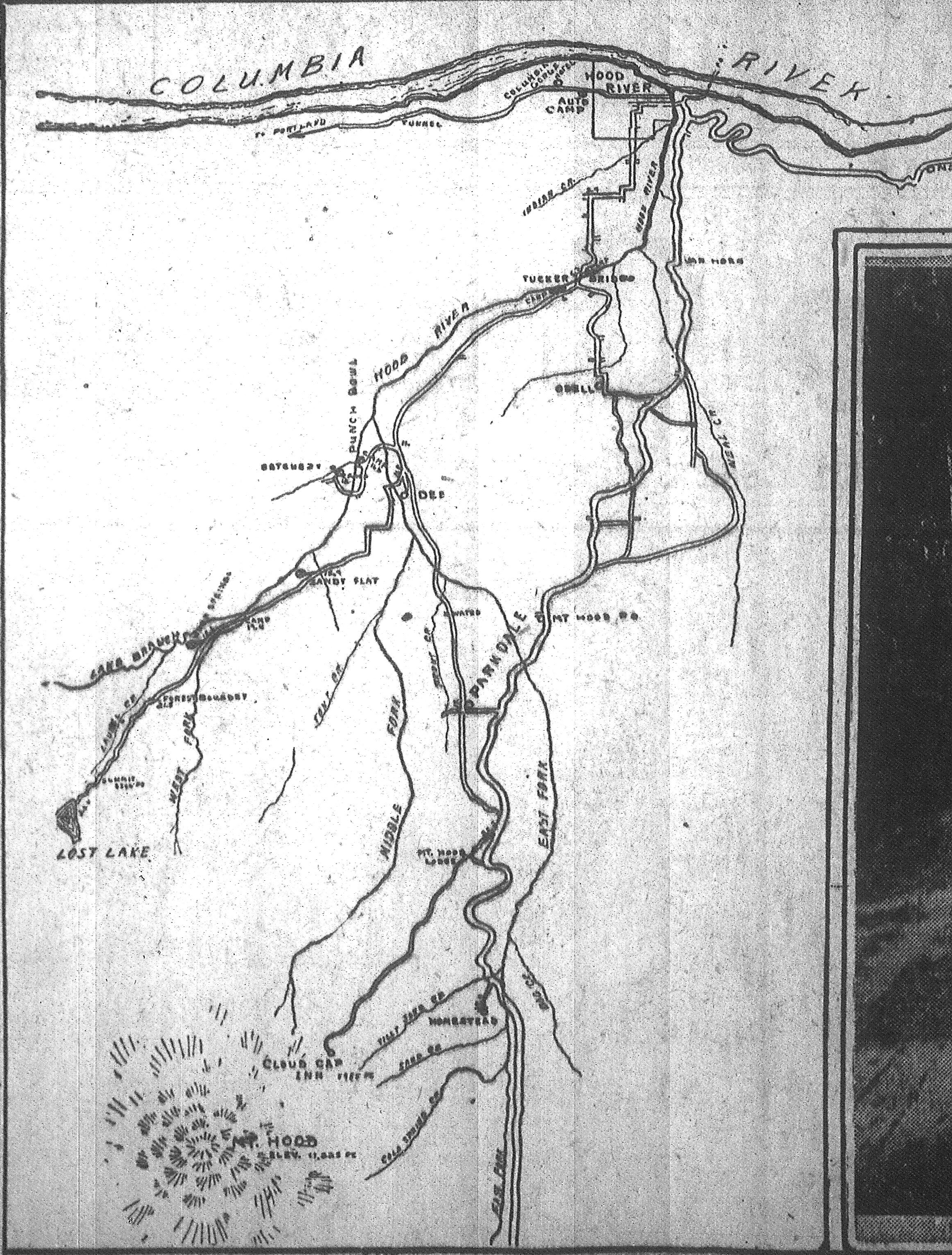
Howdy PHers! I ran across this map in the Oregonian archives, circa 1923, and was fascinated to see that it was drawn by "Mrs. James Stranahan" of the pioneering Stranahan family:

I'm focusing on the area along the Lost Lake Highway, stretching from the mill down of Dee to Lost Lake. I can't make out some of the place names along the way, but so far among the names lost to time is
Sandy Flat. I'm pretty sure the point labeled just west of where the road leaves the West Fork reads "forest boundary". Also in the area is
Punch Bowl,
Hatchery and several mileage ticks along the highway(with distances from Hood River). There was another spot called
Camp Overall somewhere along the West Fork Hood River, but I don't see it on this map.
So, if you know this area, and have any insights, let me know! Here's a much larger version of the map:
Large Stranahan Map
Thanks!
Tom

Re: 1923 Map of Hood River Valley: I need your help!
Posted: February 10th, 2013, 5:28 pm
by Limey
Tom, I live about five miles from that area. In the area marked Sandy Flat there used to be a logging railroad that went from the Dee lumber mill all the way to the lost lake area. If you go to the right after crossing the bridge at the old mill site, that road will take you to the hatchery. On the bend just before the hatchery on the right hand side of the road is an old road that is gated. Walk down that road and keep looking to your left and you will see Dead Point Falls. Walk over towards it, you will come to the west fork. Look upstream and you will be looking at the punchbowl and falls. I was just over there last week and posted some test pics in the user test forum. You can take a look. Dead point falls is really worth seeing.
Any more questions just let me know.
Marilyn
Re: 1923 Map of Hood River Valley: I need your help!
Posted: February 10th, 2013, 5:44 pm
by Limey
Me again Tom. If you go to historicmapworks.com and browse maps you can find the hood river county map for 1931. scroll down and choose the page 9 map. This is the Dee area. I don't know how to post a link yet so this is the only way i know to tell you about the maps.
Marilyn
Re: 1923 Map of Hood River Valley: I need your help!
Posted: February 10th, 2013, 6:55 pm
by Chase
Cool map, Splinty!
You can see Tucker Bridge and some of the points SW to Laurel Creek, but I see what you mean about wanting to know what those unreadable points are...I checked through my old maps and couldn't find anything revealing. Hope to see answers up here soon.
Re: 1923 Map of Hood River Valley: I need your help!
Posted: February 11th, 2013, 9:42 am
by payslee
Splintercat wrote:
I'm focusing on the area along the Lost Lake Highway, stretching from the mill down of Dee to Lost Lake. I can't make out some of the place names along the way,
Hi Tom,
The notation just to the right of "Lake Branch says something "springs". Possibly oxbow springs.
I'm with you on "forest boundary", and I suspect the next upstream notation is "summer camps".
-payslee
Re: 1923 Map of Hood River Valley: I need your help!
Posted: February 11th, 2013, 10:20 am
by payslee
And those falls pictures are great, Marilyn - thanks for posting them!
-payslee
Re: 1923 Map of Hood River Valley: I need your help!
Posted: February 11th, 2013, 9:28 pm
by Splintercat
Thanks, Marilyn, Chase and Payslee! Love this history stuff... wish I had a wayback machine, it would it research a lot easier...

-Tom
Re: 1923 Map of Hood River Valley: I need your help!
Posted: February 16th, 2013, 3:15 pm
by justpeachy
I was downtown at the Central Library today looking up a bunch of stuff on the
Oregon Journal microfilm (dang I wish they'd digitize that newspaper; there's some great stuff in it!). The library has all the
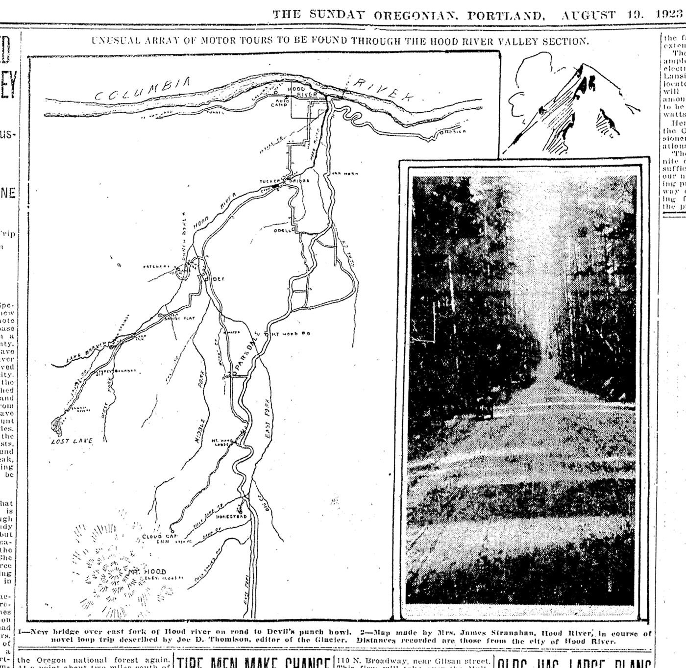
Oregonian issues on microfilm, so I thought I'd find your map, Tom, and see if it was any more readable. There are still some things that are unreadable, but you can make out more words than on the version from the database that you posted. (Click the image for a huge version.)

Re: 1923 Map of Hood River Valley: I need your help!
Posted: April 2nd, 2013, 1:49 pm
by Limey
Tom, I just finished a book called "Switchback to Timber" about the Mt. Hood railroad and the logging railroad at Dee. There is a map in the book that shows Camp Overall in the general vicinity of the Lake Branch/West Fork Confluence. A little further downstream from there it shows something called Mohr Park. I have not been able to find any information on either site.If you have any ideas on where a person would look, I'd appreciate it. Our major goal this year it to try and find as much of the logging railroad route as we can. We have already spotted some remains of one of the trestles, it's now a matter of figuring out how to get to it. We are finding it very difficult to get any history on the area from the Mill to Lost Lake. If I do run into more stuff I will let you know.
Marilyn
Re: 1923 Map of Hood River Valley: I need your help!
Posted: April 4th, 2013, 5:44 am
by Splintercat
Thanks, Marilyn - I've had my eye on that book for awhile, but so far can only find it for a small fortune (online) or at libraries in Hood River and Pendleton, I believe. I'm assuming you've got the early 1900s USGS topos for the general railroad location? If not, let me know, and I'll post a link here to the download site. The other interesting resource is a 1930s lookout panorama taken from Lost Lake Butte that actually shows a train traveling down the upper end of the line:
You can see the steam plume from the train in the distance -- this is a clip from the pano at about 33% reduction.
Cheryl, thanks for the enlarged map! I can read it! No Camp Overall, but we do get Camp 19.4 (very creative) and the springs (can't read the first word here, but it's in the article -- I'll have to hunt for it).
Tom