Owl Point, then and now...

This is a forum for trip reports that pre-date the Portland Hikers forum, trail photos from pre-digital era, or any other discussions that focus on trail history.
User avatar
Splintercat
Posts: 8334
Joined: May 28th, 2008, 10:03 pm
Location: Portland
Contact:

Owl Point, then and now...

Post by Splintercat » November 10th, 2012, 9:25 am

Ran across a cool photo on the Hood River Historical Museum archives -- from the eastern slope of Owl Point, dated 1952. It shows a recovering forest on the north slope of Katsuk Point, in the foreground. I've seen photos as early as the 1920s that show this area burned, so I suspect at this point, the recovery is several decades in the making. It also puts the age of the current forest at about 60 years, more or less.

1952 view:

Image

2011 view (before the Dollar Fire):

Image

2012 (after the Dollar Fire):

Image

Gives some interesting perspective on the fire cycle!

Tom :)

User avatar
Crusak
Posts: 3617
Joined: August 6th, 2009, 7:33 pm
Location: Oregon

Re: Owl Point, then and now...

Post by Crusak » November 10th, 2012, 12:52 pm

Interesting! That fire from the 1920's looks like it burned a much larger area, just based on what I'm seeing in that first photo. Do you think that's the case?
Jim's Hikes

Solvitur Ambulando

raven
Posts: 1531
Joined: May 28th, 2008, 10:03 pm

Re: Owl Point, then and now...

Post by raven » November 10th, 2012, 1:21 pm

As I read the photos, between 1952 and now timberline rose significantly. Does anyone around this board whose been wandering the hills for a long enough while share my impression that the alpine zone in the Cascades has been shrinking more from below than it has been expanding upward? .

User avatar
Grannyhiker
Posts: 4598
Joined: May 28th, 2008, 10:03 pm
Location: Gateway to the Columbia Gorge

Re: Owl Point, then and now...

Post by Grannyhiker » November 10th, 2012, 1:26 pm

Raven, here's a recent study from OSU that confirms your observations: http://oregonstate.edu/ua/ncs/archives/ ... -northwest

Edit, later: Credit goes to a poster on nwhikers.net who cited this study.

raven
Posts: 1531
Joined: May 28th, 2008, 10:03 pm

Re: Owl Point, then and now...

Post by raven » November 10th, 2012, 1:57 pm

Thanks, GH. I had read of the work at Jeff Park, but had forgotten the reference. Jeff Park is but one location. The photos provide a second. I was hoping rather to bring forth personal anecdotes that could spread the observed range.

One example is provided by a trip I took into Jeff Park in April 1991(?) on skis. I wasn't on the South Breitenbush trail which was well buried; rather I had noticed a slight bench on the topo map and was exploring the route. My route, above the trail often, was open and magnificent - I traveled through open meadows to above Jeff Park and skied down into it. A few years later I tried to make the trip with a friend and failed. It was as though I couldn't find my route at all. Later I realized the trees frustrating our travel on the second trip had been smaller and buried at the time of the first trip. The lack of heavy snows in the eighties meant fewer avalanches allowing the trees to establish themselves, and they filled in that snowscape during the early 1990s - between the trips.

I have other specific memories from observations at Diamond Peak and the Goat Rocks; but mostly with slow change I just update my memories slowly and miss the before and after.

User avatar
Splintercat
Posts: 8334
Joined: May 28th, 2008, 10:03 pm
Location: Portland
Contact:

Re: Owl Point, then and now...

Post by Splintercat » November 10th, 2012, 9:10 pm

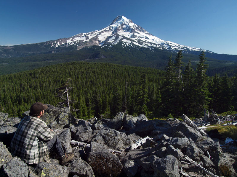
Interesting, Raven -- I've cropped a recent view to better compare to the 1952 view:

Image

More lingering snow in my version, but I do see a few spots where the trees seem to have moved up the mountain -- especially around the base of Barrett Spur.

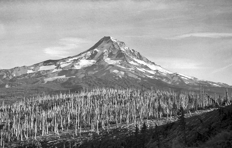
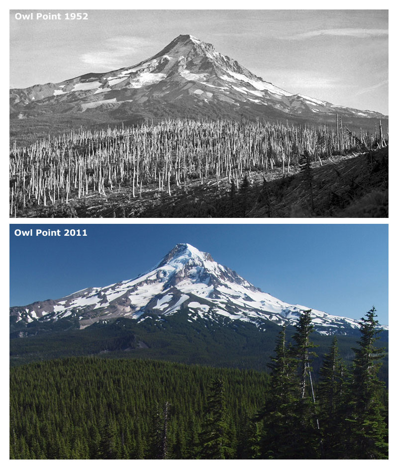
In general, I think the burn in the first photo covered an area roughly inverse of the Dollar Fire of 2011 -- that is, it burned the north side of the Clear Branch valley, but not the slopes of Mount Hood. Amazing to think when this photo was taken, there was no Mount Hood Meadows, no Laurance Lake, no powerlines over Lolo Pass, few logging roads and clear-cuts and the loop highway was a lovely 2-lane gem (and only 25 years old at the time). "Progress..?" Hmm...

Tom

User avatar
mayhem
Posts: 3579
Joined: December 22nd, 2009, 7:46 pm
Contact:

Re: Owl Point, then and now...

Post by mayhem » November 12th, 2012, 12:56 pm

The perspective is not exact but it still works ok.
Shoe Shine Boy Has Left The Building!

User avatar
Splintercat
Posts: 8334
Joined: May 28th, 2008, 10:03 pm
Location: Portland
Contact:

Re: Owl Point, then and now...

Post by Splintercat » November 12th, 2012, 5:36 pm

That's pretty cool, Mayhem! I'll have to try reproducing the exact shot sometime. I know right where they took it - just east of Owl Point. Not sure why the didn't hike up to the point, but they were within 200 yards or so.

I'm thinking this photo was taken at about the same time that Cheryl's Red Hill Guard Station photo was taken -- one is identified as 1952 (Owl Point), the other (Red Hill GS) as 1954... hmm... I'm referring to this one:

Image

Tom :)

User avatar
markesc
Posts: 1530
Joined: May 28th, 2008, 10:03 pm

Re: Owl Point, then and now...

Post by markesc » November 21st, 2012, 2:35 pm

Anyone have some old East Zig Zag mt photos vs today? I first did that hike back in the mid 90's.... when I was back up there in '09 it just didn't seem to be as open of a view from the summit compared to my recollections...

Also I heard from someone way back that they remove trees @ paradise on Rainier on purpose to save those meadows......

viking
Posts: 188
Joined: July 5th, 2009, 6:49 pm

Re: Owl Point, then and now...

Post by viking » November 23rd, 2012, 11:51 am

Great pictures! What gets me is there appears to be much more glacier, not just lingering snow. The area of the upper Coe glacier is much larger in the current photo than the '52 photo. Look at the upper Coe, Queens chair, Snow Dome and ever the Sandy Headwall. They all look significantly larger than yearly melt off would account for. What was the date taken for the current photo? Do we have any idea the month/day of the old photo?

Post Reply