Bushwhacking the "other" Shellrock Mountain

Discussions and Trip Reports for off-trail adventures and rediscovering lost trails
User avatar
Splintercat
Posts: 8334
Joined: May 28th, 2008, 10:03 pm
Location: Portland
Contact:

Bushwhacking the "other" Shellrock Mountain

Post by Splintercat » July 21st, 2008, 4:54 pm

I do not have a terminal illness..! (...that I know of...) :shock: I just happen to be knocking down some long-admired bushwhack destinations this year -- no mortality crises behind this! So far, the longtime goals have included Chak Chak Falls, the Viento Bluffs, upper tier of Lancaster Falls and the subject of this report, the "other" Shellrock Mountain. This version is a rugged peak along Surveyors Ridge, and part of the fault line that forms the east side of the Hood River Valley. Here's a panoramic view of the vicinity, taken from 99 Ridge last summer:

Image

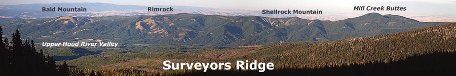
To the north of Shellrock are well-known Bald Mountain and lesser known Rimrock, a former lookout site. To the southeast are the little-known Mill Creek Buttes. This trip begins from an unmarked pullout along Forest Road 17 (detailed directions below), where the Surveyors Ridge Trail is most easily accessed. Here's the view of Shellrock Mountain from that section of trail:

Image

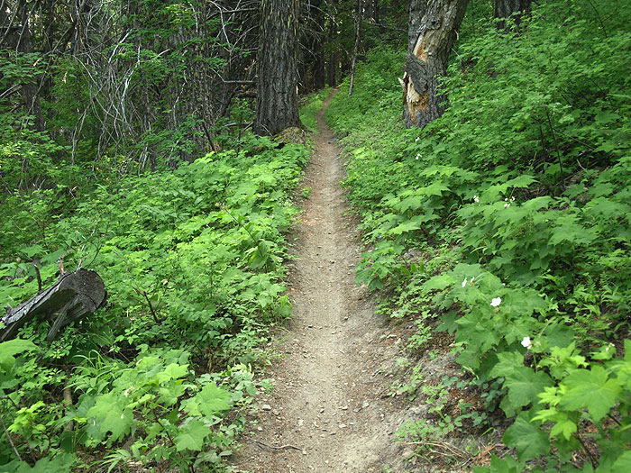
The bushwhack to the summit is up the east slope, on the left in this view. To reach the jump-off point, simply go south (right) on the unmarked Surveyors Ridge Trail, and begin a very gentle climb toward the east shoulder of the peak. The trail enters surprisingly lush forest, and the bushwhack to the summit begins from this section of trail, where it crests:

Image

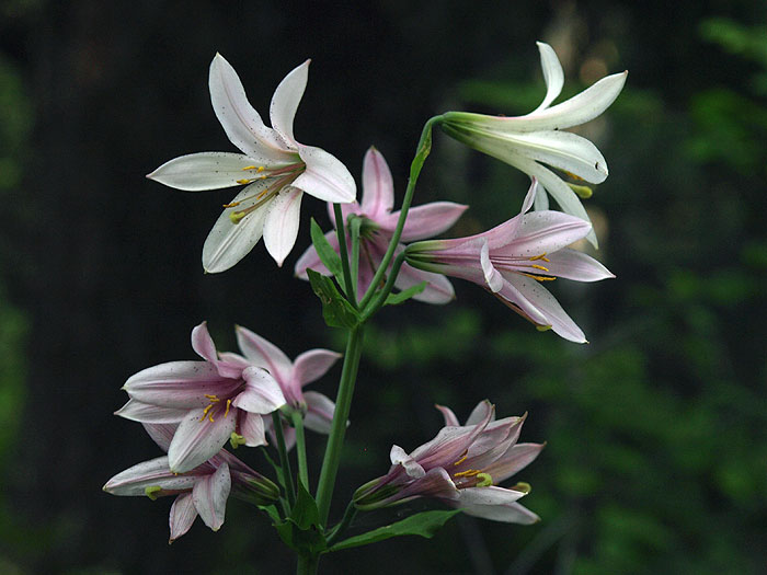
Before heading to the summit, I explored a bit more of the Surveyors Ridge Trail, north of the peak, I was surprised to see many towering Mount Hood lily, some peaking, others just opening their blossoms:

Image

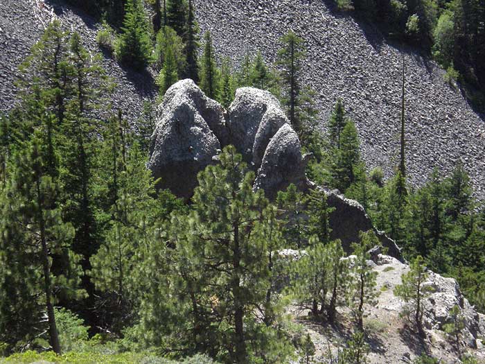
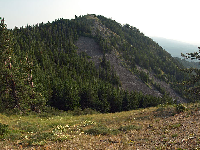
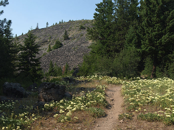
Just beyond the crest, the trail passes a sign pointing to "Shellrock Mountain", but the short path leads just a few yards to a pretty meadow, rock outcrop and view of Shellrock Mountain, towering above. A bit further, the main trail also crosses a series of meadows, and provides this view up to the loose, rocky slopes that give Shellrock it's name:

Image

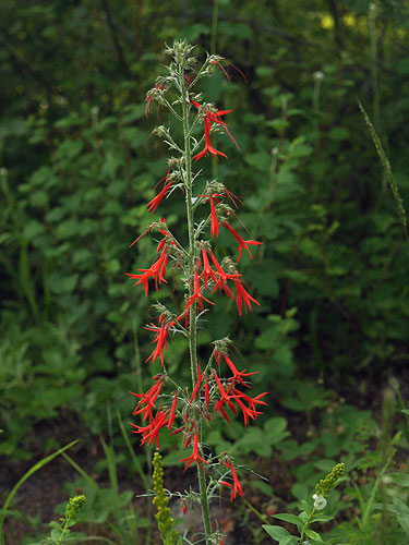
This more open section of trail has an abundance of east side wildflowers, including my own personal favorite, the beautiful skyrocket gilia:

Image

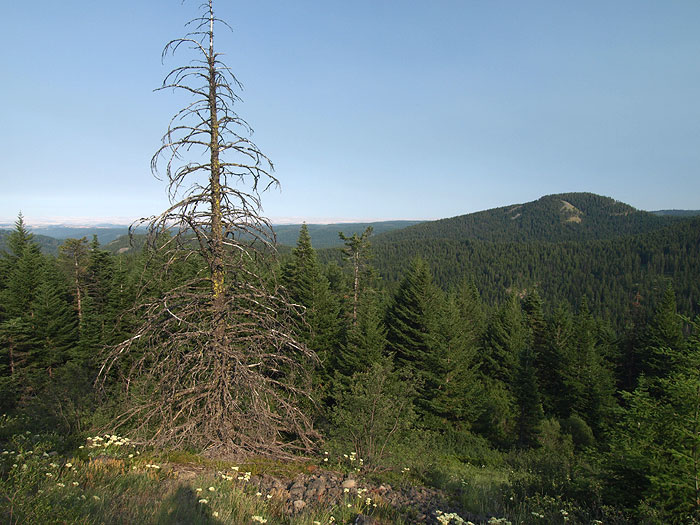
After exploring the little meadows a bit, I retraced my steps back to the gentle crest in the forest, and picked a route to the summit. There is no obvious route, here, just aiming for the light, since the forest margin is not far up the east slopes of Shellrock Mountain. After pushing through the eclectic mix of east and westside trees and shrubs, the scene opens up, and the balance of the bushwhack is simply a steep climb up loose talus, and among patches of manzanita, groves of stunted fir and ponderosea pine. Be sure to turn around here, and pick a spot for your re-entry to forest upon returning. I picked this large snag, which was easily spotted upon my descent:

Image

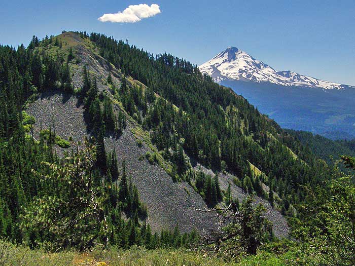
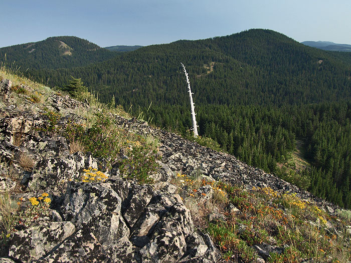
As you continue to traverse the increasingly open slopes, view into Eastern Oregon begin to unfold, as well as view into the Mill Creek Buttes, an area within The Dalles Watershed that is seldom seen or visited. In this view, Lookout Mountain is the distant ridge to the right of the buttes, and the little meadow traversed by the main trail can be seen far below, and right:

Image

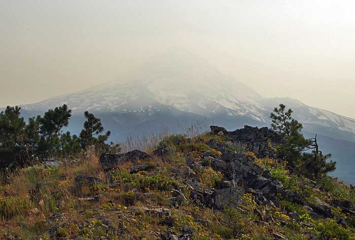
The summit views are spectacular! The summit ridge is a long, narrow crescent, with a wide-open view of Mount Hood from the south end (obscured by forest fire smoke on my trip), and this sprawling view into what I am calling Badlands Basin, from the north end of the summit -- Mount Adams would be rising above the basin on a clear day, and the trailhead for this trip is located at the edge of the trees, on the far right edge of this photo:

Image

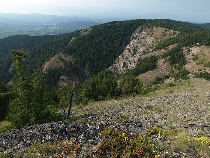
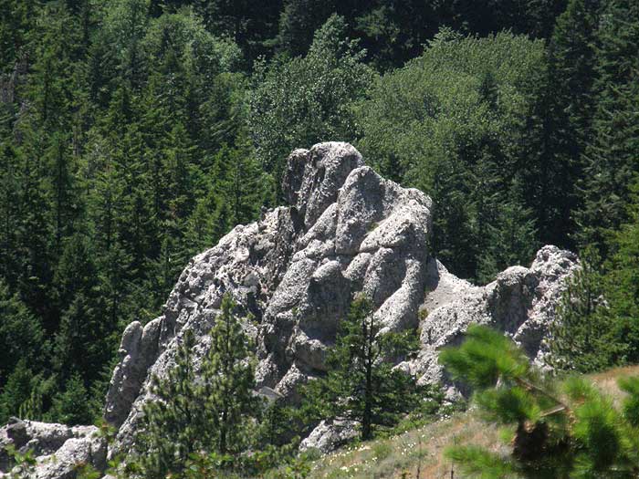
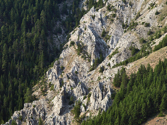
The Badlands Basin is like no other place in the Mount Hood area. I'm still researching the geology, but it looks like an ash deposit, along the lines of Annie Creek at Crater Lake. Here's a closer view of the rugged tiers of pinnacles and fins:

Image

I photographed this area from the trailhead on an earlier scouting visit, and will post images of some "goblins" that can be seen from that direction.

This would be a very manageable bushwhack for most hikers, and comparable to bushwhacking up Mt. Chinidere from the PCT if there weren't a spur trail, for example. The climb from the Surveyors Ridge Trail to the top took less than 20 minutes, and I am no Don Nelson..! :D

BTW, for those following the Trailkeepers of Oregon, this is, indeed, another area that I'm scouting for trail potential. The larger goal here is a trail from Highway 35 all the way to the summit that would cover about 4.5 miles and 3,500 feet, and some of the best scenery in the area, including a swing past Badlands Basin. But an easier short-term project could simply be a spur to the summit, making for an easy destination for families starting at the upper trailhead. Here's the route that I followed, and that roughly represents the "family" version of the trail concept:

Image

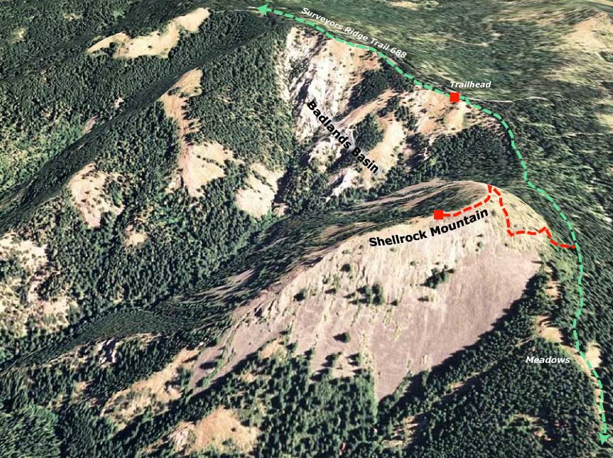
Here are directions to the trailhead shown on this map: from Hood River, follow Highway 35 south past milepost 92 and the Mount Hood Forest Products mill. As you reach the next crest, and a view of Mount Hood, watch for Pine Mont Drive, on the left. This is also Forest Road 17, and marked accordingly once you turn onto the route. Follow this sometimes paved, sometimes gravel route for 10.8 miles to a short road stub that heads off to the right. You'll also see a white marker with "M11" marking this spot. You're at the trailhead, just follow the stub to the obvious trail, and head toward Shellrock Mountain.

This was a fun trip -- and had 360 degree views -- so I guess I'll have to get Jeff up there! It would be SPECTACULAR at sunrise, especially if the forest fires are cooperating.

-Tom :)

User avatar
Splintercat
Posts: 8334
Joined: May 28th, 2008, 10:03 pm
Location: Portland
Contact:

Re: Bushwhacking the "other" Shellrock Mountain

Post by Splintercat » July 21st, 2008, 5:20 pm

A few loose ends from an earlier scouting trip to the Badlands Basin area:

Some goblins -- these look like a pair of elephants heading for the barn:

Image

...not sure what this one is!

Image

...and here's the view of Shellrock Mountain from the Badlands Basin on a clear day, with Hood in the background:

Image

-Tom

User avatar
fettster
Posts: 1720
Joined: May 28th, 2008, 10:03 pm
Location: Hillsboro, OR

Re: Bushwhacking the "other" Shellrock Mountain

Post by fettster » July 21st, 2008, 5:51 pm

Very cool Splintercat! It is very interesting to finally see some pictures of this area as I've eyed it in the past on the topo map as a candidate for a winter snowshoe. That trail from the highway to the summit would be good starter for that kind of trip. The Badlands Basin is a new one for me and definitely keeps my interest peaked to get over there sometime. What's that road like driving up and around to the summit trailhead?

Those Mount Hood Lilies are sure eye-catchers aren't they? Great shot!

pablo
Posts: 1451
Joined: May 28th, 2008, 10:03 pm

Re: Bushwhacking the "other" Shellrock Mountain

Post by pablo » July 21st, 2008, 6:05 pm

Great stuff, you have a good eye for interesting features in the terrain. Have to put this place on my list - I see some nice ridges along Puppy and Cat creeks that would be fun. The Badlands do look bad.

Thx,

--Paul
The future's uncertain and the end is always near.

User avatar
Splintercat
Posts: 8334
Joined: May 28th, 2008, 10:03 pm
Location: Portland
Contact:

Re: Bushwhacking the "other" Shellrock Mountain

Post by Splintercat » July 21st, 2008, 8:41 pm

Thanks - Fettster, the road is a piece of cake. Smooth gravel or paved with a few potholes. I should have mentioned that it's a good idea to watch for bikes on the trail, since this is a prime single track route. They can really sneak up on you, especially when you are headed downhill, and they're coming from behind.

Pablo, you'd definitely be able to exercise your inner mountain goat in this terrain. Here's an enlarged clip from the panorama, showing more of the Badlands Basin -- the photo from the summit just shows the the north half and doesn't do justice to the vastness of the amphitheater:

Image

The formation is about a half-mile across along the rim, and has a 1,200 foot vertical elevation, beginning at the canyon floor, and headwaters of Cat Creek. For the super-buff, a terrific loop could be made from the trailhead that I've mapped by dropping down the open ridges on the north slopes of the Badlands Basin, crossing Cat Creek, and ascending 1,400 feet to Shellrock Mountain, then returning via the trail segment. The winter idea is a good one, too - maybe Thomas and Fred will conquer this one when the snow falls..!

Neat area - deserves more hikers! :D

Tom

User avatar
fettster
Posts: 1720
Joined: May 28th, 2008, 10:03 pm
Location: Hillsboro, OR

Re: Bushwhacking the "other" Shellrock Mountain

Post by fettster » July 21st, 2008, 8:49 pm

Splintercat wrote:It would be SPECTACULAR at sunrise, especially if the forest fires are cooperating
Seem like there were many good places near the summit to pitch a tent?

User avatar
Splintercat
Posts: 8334
Joined: May 28th, 2008, 10:03 pm
Location: Portland
Contact:

Re: Bushwhacking the "other" Shellrock Mountain

Post by Splintercat » July 21st, 2008, 9:30 pm

Good question! The summit is entirely composed of shale clinkers and larger rock - think Chinidere Mountain, it's very similar on top, with a few flowers and grasses filling in between stones. There are definitely enough flat spots to actually set up a tent, if you have a very thick sleeping pad..! But yeah, it's no worse that doing a rocky bivouac.

I didn't post a view of the true summit, since the smoke had all but erased Hood - but in better conditions, this would be a pretty nice scene to wake up to at sunrise:

Image

Darned forest fires! I have a long history of hiking into the one spot in the entire Cascade Range that is shrouded in smoke on a given day... especially when I've dragged all my camera gear along! :lol:

Tom

User avatar
pyles_94
Posts: 1163
Joined: May 28th, 2008, 10:03 pm
Location: Portland Area
Contact:

Re: Bushwhacking the "other" Shellrock Mountain

Post by pyles_94 » July 22nd, 2008, 11:09 am

This is really cool, Tom. Keep scouting! couldnt you organize your own work parties to make small trails like this? or does it have to be official and with the trailkeepers of oregon....
Jamey Pyles

User avatar
Don Nelsen
Posts: 4382
Joined: May 28th, 2008, 10:03 pm
Location: Vancouver, WA

Re: Bushwhacking the "other" Shellrock Mountain

Post by Don Nelsen » July 22nd, 2008, 3:59 pm

Excellent report and great photos. Those badlands are interesting - I can't think of another spot north of Crater Lake that has such a large area of such features. good job!

- Don
"Everything works in the planning stage" - Kelly

"If you don't do it this year, you will be one year older when you do" - Warren Miller

User avatar
Splintercat
Posts: 8334
Joined: May 28th, 2008, 10:03 pm
Location: Portland
Contact:

Re: Bushwhacking the "other" Shellrock Mountain

Post by Splintercat » July 22nd, 2008, 9:23 pm

Jamey, the official answer to your question is absolutely not - the USFS would need to oversee a project like this, even if 100% of the work came from volunteers.

Don, I am still trying to dig up geologic info for this area. There's a ton of good geology in the vicinity, from the various massive fault lines, to the stacks of pahoe hoe that rise out of the "mile" creek canyons, along the east slopes of Lookout Mountain, to the Parkdale lava flow, yet surprisingly little field research to be found online. The Badlands Basin is just one more interesting feature in the mix. I have a hunch that it's a tilted ash layer that is related to the exposed deposits along the East Fork, just below Cold Spring Creek, and greatly pre-dates the emergence of Hood. Just a theory... more homework required!

-Tom

Post Reply