Thanks for the warm welcome everyone. I haven't been to the two upper falls, mainly 'cause the road doesn't go past the top of the big falls. To get to the upper ones, a person has to climb up the hill quite a ways, get above the never ending cliffs, and then sidehill it pretty far, only climbing back down to each falls. A rope might be in order as well. Never have done this, but I plan to scout a path in the near future.The C-Ws wrote: Have you been to the two upper waterfalls? If so, how hard is the access from the top of the main falls? Does the road/trail continue?
Thanks,
--Casey
Memaloose Falls and South Fork Clackamas River
-
BrianEdwards

- Posts: 2405
- Joined: February 2nd, 2010, 1:32 am
- Location: Oregon City, OR
- Contact:
Re: Memaloose Falls and South Fork Clackamas River
Last edited by BrianEdwards on February 5th, 2010, 10:19 pm, edited 1 time in total.
-
Splintercat

- Posts: 8334
- Joined: May 28th, 2008, 10:03 pm
- Location: Portland
- Contact:
Re: Memaloose Falls and South Fork Clackamas River
Great report, Brian - and welcome! This one has been on my list since seeing it on the Oregon Kayakers site several years ago (though the photos of that final tunnel past the big falls creeped me out, much less the thought of crossing the rotten log bridge..!)
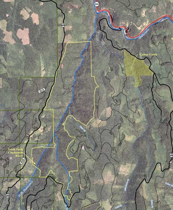
Okay, shoot me for saying this, but I would LOVE to see these old roads (and tunnels) reopened as trails. Now that the area above Memaloose Creek is inside a wilderness boundary (yellow line on the map, below), bridges are problematic, but the kayakers were able to "portage" the rotten bridge without any problem by traversing the canyon wall. The bridge to Memaloose Creek could stay, or become a hiking bridge, since it's below the wilderness boundary. The trailhead could be at the Clackamas River bridge upstream from the South Fork.
Tom
-
greglief

- Posts: 640
- Joined: May 28th, 2008, 10:03 pm
- Location: Northern and Western Hemispheres
- Contact:
Re: Memaloose Falls and South Fork Clackamas River
Welcome Brian!
Thanks very much for the trip report and photos. I shall add those to my ever-growing "must-visit" list!
Greg
Thanks very much for the trip report and photos. I shall add those to my ever-growing "must-visit" list!
Greg
-
Stevefromdodge

- Posts: 2508
- Joined: May 28th, 2008, 10:03 pm
Re: Memaloose Falls and South Fork Clackamas River
Welcome to the site Brian! Looks like a VERY interesting place.
Can you post some driving directions?
Can you post some driving directions?

Re: Memaloose Falls and South Fork Clackamas River
Super OTTR Brian! One Q, is this anywhere near Memaloose Lake? I stumbed onto that lake back in my high school days..
Always Dreaming of the Trail
http://www.johnathanwhite.com
http://www.johnathanwhite.com
-
RobFromRedland

- Posts: 1095
- Joined: May 28th, 2008, 10:03 pm
Re: Memaloose Falls and South Fork Clackamas River
Tom:Splintercat wrote: Okay, shoot me for saying this, but I would LOVE to see these old roads (and tunnels) reopened as trails. Now that the area above Memaloose Creek is inside a wilderness boundary (yellow line on the map, below), bridges are problematic, but the kayakers were able to "portage" the rotten bridge without any problem by traversing the canyon wall. The bridge to Memaloose Creek could stay, or become a hiking bridge, since it's below the wilderness boundary. The trailhead could be at the Clackamas River bridge upstream from the South Fork.
Three things:
1. They would make great trails, although I think it would require a good amount of work to bring them up to current standards. It was one of the coolest hikes I've ever done....
2. The "portage" around the rotten log bridge isn't terribly easy (the route along one side is VERY narrow with poor footing).
3. Where did you get the photo of the wilderness area? I still would like to get a good map of all the new wilderness areas.
Thanks
Rob
Life is not a journey to the grave with the intention of arriving safely in a pretty and well-preserved body, but rather to skid in broadside, thoroughly used up, totally worn out, and loudly proclaiming: WOW! What a ride! - Hunter S. Thompson
-
BrianEdwards
- Posts: 2405
- Joined: February 2nd, 2010, 1:32 am
- Location: Oregon City, OR
- Contact:
Re: Memaloose Falls and South Fork Clackamas River
Hey steve, to get there start in Estacada and head up the Clackamas on hwy 224. Go past North Fork Reservoir, past the boat ramp and promontory park. About two or three miles past there you'll see a small green bridge that crosses the river, the sign says Memaloose Road, take a right over this narrow bridge. The road heads uphill. After a short bit, you'll reach a hard left with an expansive view of the South Fork Clackamas River canyon. The Lower falls are a hard scramble down this cliff/hill if one wants. To get to where I started, keep goin up the road for maybe 3/4 mile and you will clearly see that closed spur road on the right. Park and follow my trip report. It's a hard scramble to and from the spur road to the tunnel but as Rob and others have said, it's an interesting area to be had.Stevefromdodge wrote:Looks like a VERY interesting place.
Can you post some driving directions?
Last edited by BrianEdwards on March 2nd, 2010, 10:29 pm, edited 3 times in total.
-
BrianEdwards
- Posts: 2405
- Joined: February 2nd, 2010, 1:32 am
- Location: Oregon City, OR
- Contact:
Re: Memaloose Falls and South Fork Clackamas River
Hey there, this hike is many many miles downstream of the lake. The lake is the start of the creek, this hike is at the end of the creek. I've never explored the creek between these two places, one of my to-do projects.J_W_Speed wrote:One Q, is this anywhere near Memaloose Lake? I stumbed onto that lake back in my high school days..
Last edited by BrianEdwards on February 5th, 2010, 10:23 pm, edited 1 time in total.
Clackamas River Waterfall Project - 95 Documented, 18 to go.
Re: Memaloose Falls and South Fork Clackamas River
The last part of the portage around the log bridge is very narrow and sketchy. If there were a trail there, it might require blasting to complete, which is obviously out of the question inside the wilderness area. However, I think it would be quite feasible to create a trail to the base of the largest falls.Splintercat wrote: Okay, shoot me for saying this, but I would LOVE to see these old roads (and tunnels) reopened as trails. Now that the area above Memaloose Creek is inside a wilderness boundary (yellow line on the map, below), bridges are problematic, but the kayakers were able to "portage" the rotten bridge without any problem by traversing the canyon wall. The bridge to Memaloose Creek could stay, or become a hiking bridge, since it's below the wilderness boundary.
It also might make more sense to have the trailhead either at the spur road mentioned here or else on Memaloose road where it bends above the confluence with the main Clackamas. That would make for a shorter and easier-to-build trail than if it were to start at the bridge upstream. It's been a while since I've bushwhacked that stretch, but if I remember correctly, there are some sketchy areas where there is thick brush and cliffs close to the river, whereas above the confluence the slopes are much more open.
--Casey
-
Splintercat
- Posts: 8334
- Joined: May 28th, 2008, 10:03 pm
- Location: Portland
- Contact:
Re: Memaloose Falls and South Fork Clackamas River
Thanks, Casey -- I remember that from your earlier report, now.
Rob, here are the maps: Lewis & Clark Wilderness Maps
-Tom
Rob, here are the maps: Lewis & Clark Wilderness Maps
-Tom