Yes, I would! Friends of mine in Multnomah County Search and Rescue have been mapping the area, but there's still stuff they don't know. Ran into several semi-lost people up in this area today. Wearing jeans and shorts, of course.Don Nelsen wrote: For now, if you would like to have a track or a map, just ask.
don
Primrose Trail?
Re: Primrose Trail?
-
Eric Peterson

- Posts: 4097
- Joined: May 11th, 2009, 5:39 am
- Location: Oregon
- Contact:
Re: Primrose Trail?
I have 1980 and don't see the Primrose Path in their map. Scanned it with my phone and attached -VanMarmot wrote:In the old (1980, 1988) Lowe guides to the Gorge (35 Trails...), a trail (the "Primrose Trail") is clearly shown descending directly down the NE ridge from the top of Devil's Rest to the trail leading down to Wahkeena Springs.
-
Don Nelsen

- Posts: 4380
- Joined: May 28th, 2008, 10:03 pm
- Location: Vancouver, WA
Re: Primrose Trail?
Here's what I have updated to last week. This is every trail/road/etc. I've followed over the past ten years or so. There are a few overgrown sections of old roads/cat tracks not on this map but most are faint and so overgrown I think it unlikely that a lost hiker would end up following any of them. I have this map in .tpo format and you can have the file if you can use it - just send a PM with an e-mail address.aircooled wrote:Yes, I would! Friends of mine in Multnomah County Search and Rescue have been mapping the area, but there's still stuff they don't know. Ran into several semi-lost people up in this area today. Wearing jeans and shorts, of course.Don Nelsen wrote: For now, if you would like to have a track or a map, just ask.
don

"Everything works in the planning stage" - Kelly
"If you don't do it this year, you will be one year older when you do" - Warren Miller
"If you don't do it this year, you will be one year older when you do" - Warren Miller
-
Grannyhiker

- Posts: 4598
- Joined: May 28th, 2008, 10:03 pm
- Location: Gateway to the Columbia Gorge
Re: Primrose Trail?
It was called the "Primrose Path" (not trail), and that was the path that led to perdition, or hell, if you prefer. Of course that was by association with Devil's Rest. I hiked it several times before the fire.
I tried to find it a few years ago but gave up. It was a hot day in July and very humid up there aon Devil's Rest (evidently it had recently rained, because the foliage was sopping wet. I actually didn't spend much time looking for it.
I tried to find it a few years ago but gave up. It was a hot day in July and very humid up there aon Devil's Rest (evidently it had recently rained, because the foliage was sopping wet. I actually didn't spend much time looking for it.
-
scrambler2
- Posts: 449
- Joined: June 20th, 2008, 11:38 am
Re: Primrose Trail?
That is almost as bad as wearing shoes and socks.aircooled wrote: Ran into several semi-lost people up in this area today. Wearing jeans and shorts, of course.
PCT class of 2012
-
retired jerry

- Posts: 14418
- Joined: May 28th, 2008, 10:03 pm
Re: Primrose Trail?
hmmm...
shorts inside and jeans outside?
vice versa would be pretty weird
shorts inside and jeans outside?
vice versa would be pretty weird

Re: Primrose Trail?
My bad. The Primrose is shown on two maps in Lowe's 1988 edition but not in the 1980 edition.Eric Peterson wrote:I have 1980 and don't see the Primrose Path in their map. Scanned it with my phone and attached -VanMarmot wrote:In the old (1980, 1988) Lowe guides to the Gorge (35 Trails...), a trail (the "Primrose Trail") is clearly shown descending directly down the NE ridge from the top of Devil's Rest to the trail leading down to Wahkeena Springs.
I'm guessing it was only in their '88 edition which I don't have

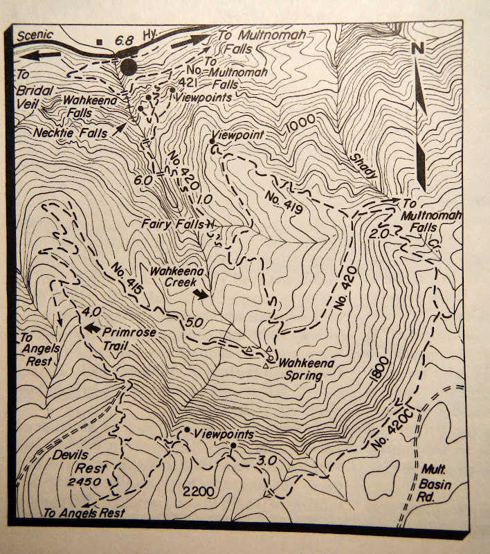
Since my 2010 posting, I did try to follow the nominal track of the Primrose from Devils Rest to Trail 415. There is still some signage right below the Rest but after that it was mostly a bushwack. The fire and subsequent regrowth seems to have really done a job on the visibility of the track.
Re: Primrose Trail?
DN and I scouted the Primrose yesterday. We first started down a tread from the rock of gnomes, but it ended. However there was a terrific view of Mt. St. Helens where it ended!
We then headed down a track to the east of the summit and found a little wooden devil sign on a tree, left of the trail. We headed down and found some flagging which we followed until reaching a nasty swatch of chest high salmonberry. No obvious way around so we plunged in and headed NW across it towards some trees. More flagging! At this point we found a faint tread with lots of fir needles covering it. The Primrose. We were able to follow this tread all the way down, although the old switchbacks were pretty well covered by debris.
http://gpsfly.org/g/3223
Here are a few waypoints. Hopefully I wasn't getting too much GPS bounce when I took these.
Start of trail: N45 33 46.2 W122 07 41.8
Large tree just before swath of salmonberry begins. N45 33 50.0 W122 07 43.2
Best viewpoint on trail - large rocky outcropping. N45 33 58.3 W122 07 45.6
Primrose meets #415: N45 34 06.3 W122 07 49.9
Last edited by aircooled on April 10th, 2014, 8:13 am, edited 1 time in total.

Re: Primrose Trail?
Eric and I did Primrose back in February. It was mostly easy to follow until the last 1/4 - 1/8th of a mile below Devil's Rest. The path is faint and requires a little routefinding, but it's still there. Eric correctly noted that it's the only trail in that area that has views!
#pnw #bestlife #bitingflies #favoriteyellowcap #neverdispleased

Re: Primrose Trail?
I hiked it once, I think it was the year before the Multnomah Falls fire. At the time I did it, it was fairly brushy in places and required being on all fours to get past some of the brush. It is so overgrown now that there is no trace of it at the lower end. The location of the lower end had been on a turn just above the talus field you encounter a half mile past Wahkeena Springs. At one time there was a primrose garden marking the route.