GoalTech's Mt Hood High Route CCW - My greatest adventure 08-26-19
Posted: September 5th, 2019, 9:26 pm
Mt Hood High Route CCW (Preview)
“Best hike I've ever done”
8/23/19 - 8/26/19
Rating: 5 Stars
Miles: 31.6
Days: 4
Time: 39 hrs, 50 min
Avg MPH: 0.8
Elev Min: 3,260'
Elev Max: 8,620
Total Ascent: 14,250'
Steps: 106,400'
Flights of Stairs: 1,098
Temp Low: 40
Temp High: 70
Other hikers: 24
Longest time without seeing a hiker: 26 hrs, 20 min
Wildlife: Orange butterflies, crows, other birds
Verizon Cell Service: Mostly weak LTE, some no service down low
(I didn't proof this as I need to go to bed, so please forgive any typos or nonsense)
Well, I did it. I hiked my Mt Hood High Route in its best form after many scouting hikes, much research, with the help of others, after 3 years of planning and a "prototype" CW hike last year.
It was the coolest thing I've ever done in my life...and I've been fortunate to be able to do some pretty cool stuff. The weather was almost perfect except for the 24 hours of wind from the first night through the second night. It was great to have a partner this year with me, my buddy "Clark Kent" (he's always changing clothes). A massive shout out to my Mt Hood hiking mentor "Chip Down", who was a huge factor in refining my route and giving me the confidence to tackle some routes that were intimidating for me.
Day 1:
We started off at Timberline Lodge, leaving at 7am on Hood-to-Coast day. Leaving early was a help. We heard the starting calls all the way up White River Glacier. We headed up the climber's route and dropped down the chute by Silcox Hut's elevation to the White River. After looking at Mamie Falls, we climbed the nose of the moraine and headed up to the base of White River Glacier. We went up the Wy East climber's route to our highest elevation of the hike. This getting up the upper moraine crest was very challenging and semi-sketch on slippery glacial ice in a few spots.
Once on top, we contoured easily over the upper fingers of Pittock and Dryer Glaciers to the Super Bowl moraine above Mt Hood Meadows. We crossed Super Bowl pretty easily and went under the base of (Newton-Clark Falls?) [It's kinda fun to name all the unnamed features up this high that are unvisited/unknown/unnamed.]. We skirted under the falls and across the hanging meadow and then side-hilled down the N-C moraine to gain its crest (hard work!). Then we went up to the termination of that moraine at the N-C prow.
We dropped into the surprisingly park-like setting below the N-C glacier, crossed the creeks in the bowl and almost scrambled up some sturdy rock faces up to the back of the N-C glacier, which is stunning to see so close. We contoured along its base to a large hill where you can go above or below. We went below to avoid the extra climb and the more exposed snow slope. We dropped down below the bowl of snow and around and then back up just a bit, just above the cascading waterfalls to gain the ridge and get spit out to what I call Spaceship Rock and The Football Field, one of my favorite features on the mountain.
Up we went where we saw a cavernous hole in the snow down to a raging creek. We admired the high-volume and tall Cooper Falls and then semi-scrambled up just a bit on some green in-filled rocks up the the mini football field and our camp site by Cooper Creek.
At 2am, the winds came up. I can't believe my Zpacks Solplex non-freestanding tent stayed upright. It was loose in the morning, but it held up. Putting big rocks on the stakes were a major help. Clark's MSR tent tore where the trekking pole handle goes into the tent pocket to hold it up, so he cowboy camped the rest of the night.
Day 2:
We started at 7:30 up the moraine to the crest of Cooper Spur. Once on top, we went out to Tie In Rock to sit out of the wind for a few minutes. We followed the climber's route down to the shelter where we saw the first few people since we started the hike the day before. We went to the Eliot moraine and couldn't find the use-trail down so we made our own and side-hilled down to the glacier. We crossed it in a routine manner, finding a small interior airplane part that we wondered if it was part of the crash up high last year. It was a tad tricky to find the best way out as the view from down low hides some false "summits" of multiple sub-moraines. We did exit the usual way, just below the cliff band of rocks. We saw three people roped up down below practicing glacier travel on the white glacier, going up towards the crevasses.
We crossed over above Langille Crags and dropped down and glissaded on Langille Glacier to Mooney Tarn where we had lunch and took a brisk swim. (Felt very refreshing). We dropped down to check out the Mooney plane crash from a long time ago before heading up and out to contour over to the Coe Glacier. There were a few mini moraines in here that were surprisingly sketchy with their steepness and crusty soil. After falling on our backside and dodging small boulders broken free we made it to the edge of Coe. What a magnificent sight up so high.
We dropped down a ways and made our own path down the moraine and crossed pretty easily where was saw that the main channel of the Coe looked least sketchy. We made quick work of it and headed for the upper terminus of the moraine on the other side. We quickly got to the top of that and dropped into the valley on the other side of it and followed it down to Elk Cove. This was a fun meeting of the day as I finally got to meet my Mt Hood hiking mentor, Chip Down! We had a great visit, but sunset was approaching and we were both a bit late, so we went on our way after about 20 minutes. On a side note, as I was approaching Chip, my foot slipped and I torqued my trekking pole in a rock and snapped it. That's why I brought my cheap Costco poles for this hike rather than my expensive Lekis! That's a total of 4 broken trekking poles in two MHHR trips! (if you're keeping score). We headed up the meadow along the creek to the top of the Barrett Spur moraine. We went up the moraine toward Barrett Spur and the wind kept getting stronger and stronger. We were convinced that we would find a suitable camp. We had wanted to camp on the Spur, but it was getting late and REALLY windy. At the saddle we found a decent spot on the leeward side. It was still breezy, but at least not gale force! We both cowboy camped to avoid the windy mess with the tents. It was a 40-degree night with wind all night, but we stayed toasty warm and enjoyed the view of the stars and watching the Big Dipper rotate through the night.
Day 3:
We left camp at 8:20 and immediately headed up Barrett Spur. It was still pretty cold and it was still very windy. We were totally exposed, but felt pretty alive as we snaked up the crest. This has got to be one of the coolest spots on the mountain. We went out to the far nose toward the mountain and soaked it in before finding a big rock to have 2nd breakfast by. We dropped down Barrett on the Ladd side. This is always the crux of the hike. We had a view hand-hold steps to get along a lower rock band that would have made me sweat a lot more if we had been up higher. After going through, I think I know of a modification of this path down or a different path down from the saddle out to the front nose that would be better. Once down, we saw a crack in the Ladd snow that dropped down a ways, so we got onto the big rocks and started over and down Ladd Glacier. We glissaded a bit down to the flat below the top of Gladd Ridge and easily gained that ridge. Once we got off of Barrett, the wind pretty much died down.
Then it was straight up above Gladd Ridge to start over the top of Glisan Glacier. I had scouted a track across the glacier earlier this summer, but the snow was now covered in cracks and it looked to be trickier to get to the top of Cathedral Ridge with the lower snow levels. So we stayed high and really enjoyed "Gladd Park" above the ridge. We crossed some high fingers of snow and contoured down to Co Pass, just above Co Rock. It was stunning to see Co Rock from above.
We dropped surprisingly easy into the Sandy Glacier and glissaded down its edge about 1/2 way down to where we needed to be. We then followed the small creek as the rocks were nice and consolidated. Then we crossed over to the Muddy Fork headwaters and crossed a couple of forks. The ice caves are fundamentally gone, but there are some mini caves up there. We dropped down to the cliff where the Muddy Fork falls over and crossed it there. This again was a surprising mini-crux as the side hill was steep and unconsolidated causing both of us to slip to our backsides and "glissade" on rock for a short bit. (I don't recommend that...not very enjoyable). After crossing the multiple forks, we went up one of the small forks to get back up higher and cross over the upper cliff edges in their gardens, which were beautiful. Our plan was to drop down to the natural saddle in Yocum Ridge to exit. We both agreed that we should have stayed higher to exit up high, just below the rock on Yocum Ridge. So that's a tiny improvement for the next time. Once we were at Yocum, we had gone just 4.55 miles in 9 hours and 20 minutes! In the next hour and a half (on-trail) we doubled our mileage for the day.
We examined the Reid from the viewpoint and both agreed that there was no way at all to cross that up high. We quickly got down to Ramona Falls at sunset with no one there, crossed the Sandy and then searched as quickly as possible for an open campsite as dusk was upon us. We found one in the nick of time before dark. We ate dinner and setup camp in the dark and had a glorious, windless night.
Day 4:
We were up before dawn and out of camp by 6:45am. We had 4,600' straight to climb! We had this crazy idea to try to make the Timberline Lodge Buffet before 10:30. We knew that was likely crazy, but oh well. We hauled up the trail quickly and met our only thru-hiker of the hike, Hawkeye from Iowa. Of course I brought trail magic with me so I gave him a bag of chips. We got to the Paradise Park trail and continued on up that and then kept going once it started to contour the other way. We climbed all the way up the edge of the Reid Glacier canyon marveling at the maze in there. We cruised up and over the top of Mississippi Head to Zigzag Glacier and found several snow fields to glissade down including the upper finger of snow going down Little Zigzag Canyon. We cut over on a few minor moraines and came out right at the top of the Magic Mile chairlift at Timberline with the Silcox Hut in the background. We did our "victory lap" going down the Silcox Trail, directly to Timberline Lodge.
We made it. It was so incredibly awesome. We took "bucket showers' in the parking lot and went straight to the Huckleberry Inn in Govy for a massive amount of pancakes, coffee, Sprite, ice cream and maple bars. Dang that was good!
Here are a few of my favorite pictures of the hike.
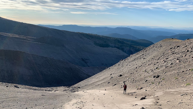
Dropping down to White River:
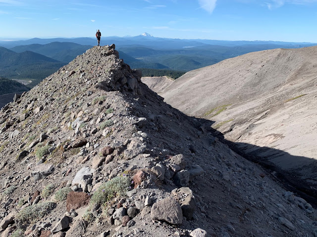
Looking back on the White River moraine climb:
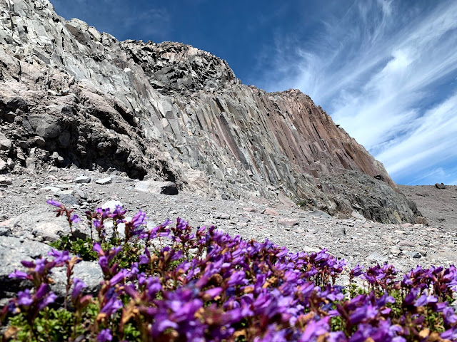
Beardtongue at the base of Newton-Clark Falls:
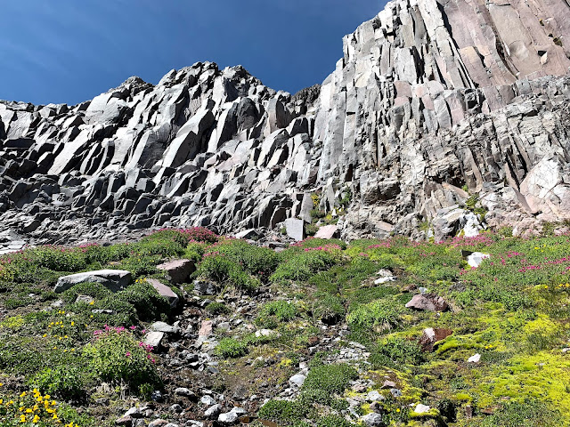
Hanging Meadow at the base of the cliff below N-C moraine:
Newton-Clark Hanging Glacier and falls: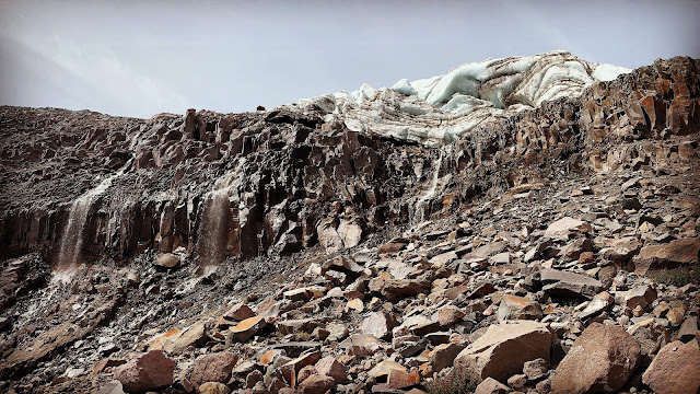
Newton-Clark Glacier and tarn:
Spaceship Rock and The Football Field:
Mt Hood under Spaceship Rock:
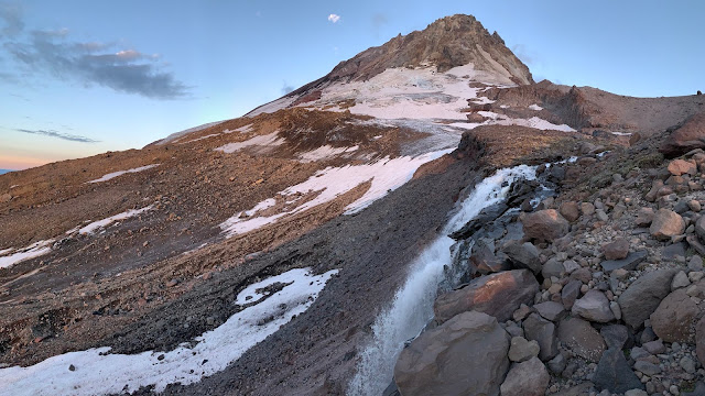
Cooper Falls at sunrise:
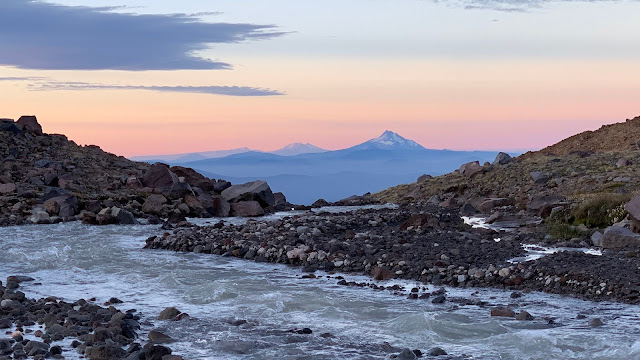
Cooper Creek leading to Cooper Falls with Mt Jefferson at dawn:
Eliot Glacier:
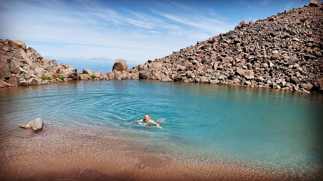
Mooney Tarn:
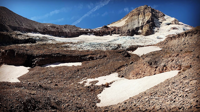
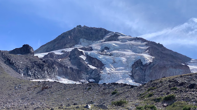
Coe Glacier:
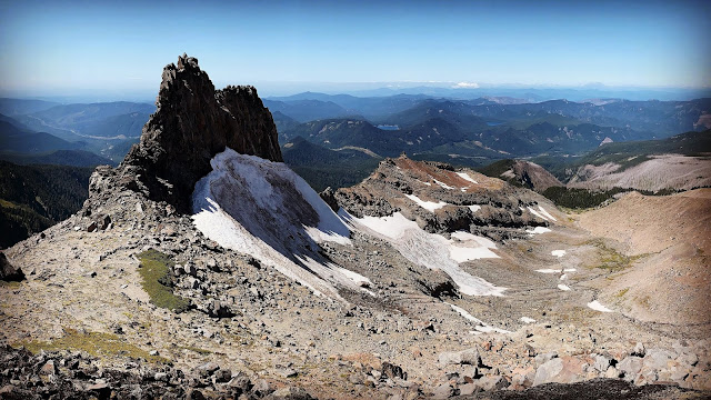
Co Pass at Co Rock and Glisan Glacier:
Mississippi Head and Mt Jefferson:

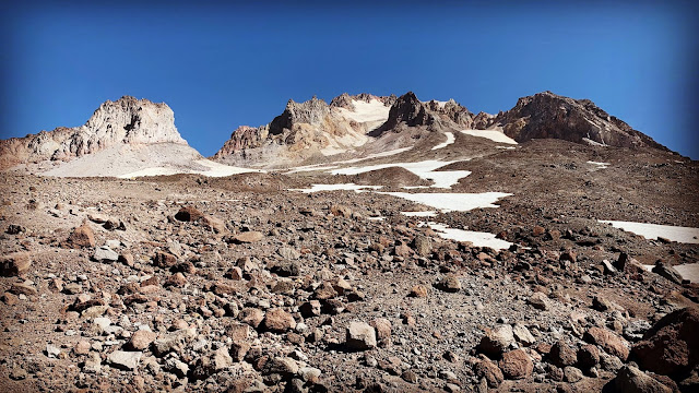
Illumination Rock and the South of Mt Hood and Crater Rock:
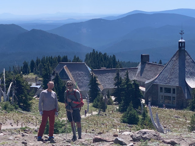
GoalTech and Clark Kent at the finish line at Timberline Lodge:
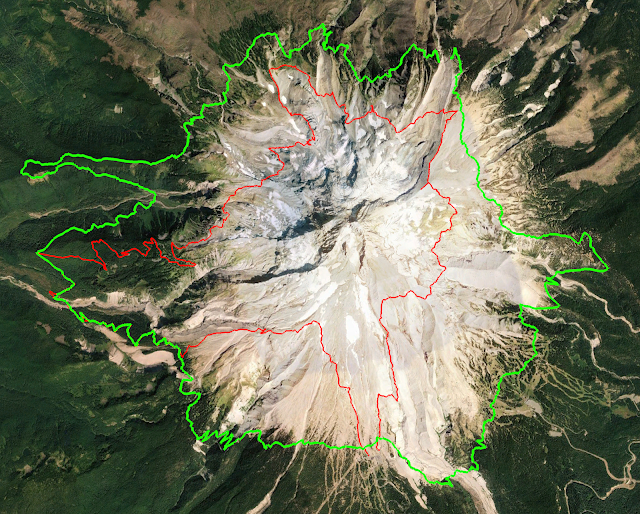
Timberline Trail in green, GoalTech's Mt Hood High Route in red:
GPS Track:
https://www.gaiagps.com/public/egqDaXAduPohRXhxIBqPgfJH
If you have ideas for improvement or corrections, please let me know. If you plan to do any or all of this, I'd request that you let me know so that I can share what I learned. The last thing I'd want is for someone to run into problems due to getting in over their head. This is extremely hard, taxing, and fraught with risk due to exposure, rock movement, falls, etc.
P.S. I got a little carried away with my "preview" (typical)
Happy Trails!
GoalTech
“Best hike I've ever done”
8/23/19 - 8/26/19
Rating: 5 Stars
Miles: 31.6
Days: 4
Time: 39 hrs, 50 min
Avg MPH: 0.8
Elev Min: 3,260'
Elev Max: 8,620
Total Ascent: 14,250'
Steps: 106,400'
Flights of Stairs: 1,098
Temp Low: 40
Temp High: 70
Other hikers: 24
Longest time without seeing a hiker: 26 hrs, 20 min
Wildlife: Orange butterflies, crows, other birds
Verizon Cell Service: Mostly weak LTE, some no service down low
(I didn't proof this as I need to go to bed, so please forgive any typos or nonsense)
Well, I did it. I hiked my Mt Hood High Route in its best form after many scouting hikes, much research, with the help of others, after 3 years of planning and a "prototype" CW hike last year.
It was the coolest thing I've ever done in my life...and I've been fortunate to be able to do some pretty cool stuff. The weather was almost perfect except for the 24 hours of wind from the first night through the second night. It was great to have a partner this year with me, my buddy "Clark Kent" (he's always changing clothes). A massive shout out to my Mt Hood hiking mentor "Chip Down", who was a huge factor in refining my route and giving me the confidence to tackle some routes that were intimidating for me.
Day 1:
We started off at Timberline Lodge, leaving at 7am on Hood-to-Coast day. Leaving early was a help. We heard the starting calls all the way up White River Glacier. We headed up the climber's route and dropped down the chute by Silcox Hut's elevation to the White River. After looking at Mamie Falls, we climbed the nose of the moraine and headed up to the base of White River Glacier. We went up the Wy East climber's route to our highest elevation of the hike. This getting up the upper moraine crest was very challenging and semi-sketch on slippery glacial ice in a few spots.
Once on top, we contoured easily over the upper fingers of Pittock and Dryer Glaciers to the Super Bowl moraine above Mt Hood Meadows. We crossed Super Bowl pretty easily and went under the base of (Newton-Clark Falls?) [It's kinda fun to name all the unnamed features up this high that are unvisited/unknown/unnamed.]. We skirted under the falls and across the hanging meadow and then side-hilled down the N-C moraine to gain its crest (hard work!). Then we went up to the termination of that moraine at the N-C prow.
We dropped into the surprisingly park-like setting below the N-C glacier, crossed the creeks in the bowl and almost scrambled up some sturdy rock faces up to the back of the N-C glacier, which is stunning to see so close. We contoured along its base to a large hill where you can go above or below. We went below to avoid the extra climb and the more exposed snow slope. We dropped down below the bowl of snow and around and then back up just a bit, just above the cascading waterfalls to gain the ridge and get spit out to what I call Spaceship Rock and The Football Field, one of my favorite features on the mountain.
Up we went where we saw a cavernous hole in the snow down to a raging creek. We admired the high-volume and tall Cooper Falls and then semi-scrambled up just a bit on some green in-filled rocks up the the mini football field and our camp site by Cooper Creek.
At 2am, the winds came up. I can't believe my Zpacks Solplex non-freestanding tent stayed upright. It was loose in the morning, but it held up. Putting big rocks on the stakes were a major help. Clark's MSR tent tore where the trekking pole handle goes into the tent pocket to hold it up, so he cowboy camped the rest of the night.
Day 2:
We started at 7:30 up the moraine to the crest of Cooper Spur. Once on top, we went out to Tie In Rock to sit out of the wind for a few minutes. We followed the climber's route down to the shelter where we saw the first few people since we started the hike the day before. We went to the Eliot moraine and couldn't find the use-trail down so we made our own and side-hilled down to the glacier. We crossed it in a routine manner, finding a small interior airplane part that we wondered if it was part of the crash up high last year. It was a tad tricky to find the best way out as the view from down low hides some false "summits" of multiple sub-moraines. We did exit the usual way, just below the cliff band of rocks. We saw three people roped up down below practicing glacier travel on the white glacier, going up towards the crevasses.
We crossed over above Langille Crags and dropped down and glissaded on Langille Glacier to Mooney Tarn where we had lunch and took a brisk swim. (Felt very refreshing). We dropped down to check out the Mooney plane crash from a long time ago before heading up and out to contour over to the Coe Glacier. There were a few mini moraines in here that were surprisingly sketchy with their steepness and crusty soil. After falling on our backside and dodging small boulders broken free we made it to the edge of Coe. What a magnificent sight up so high.
We dropped down a ways and made our own path down the moraine and crossed pretty easily where was saw that the main channel of the Coe looked least sketchy. We made quick work of it and headed for the upper terminus of the moraine on the other side. We quickly got to the top of that and dropped into the valley on the other side of it and followed it down to Elk Cove. This was a fun meeting of the day as I finally got to meet my Mt Hood hiking mentor, Chip Down! We had a great visit, but sunset was approaching and we were both a bit late, so we went on our way after about 20 minutes. On a side note, as I was approaching Chip, my foot slipped and I torqued my trekking pole in a rock and snapped it. That's why I brought my cheap Costco poles for this hike rather than my expensive Lekis! That's a total of 4 broken trekking poles in two MHHR trips! (if you're keeping score). We headed up the meadow along the creek to the top of the Barrett Spur moraine. We went up the moraine toward Barrett Spur and the wind kept getting stronger and stronger. We were convinced that we would find a suitable camp. We had wanted to camp on the Spur, but it was getting late and REALLY windy. At the saddle we found a decent spot on the leeward side. It was still breezy, but at least not gale force! We both cowboy camped to avoid the windy mess with the tents. It was a 40-degree night with wind all night, but we stayed toasty warm and enjoyed the view of the stars and watching the Big Dipper rotate through the night.
Day 3:
We left camp at 8:20 and immediately headed up Barrett Spur. It was still pretty cold and it was still very windy. We were totally exposed, but felt pretty alive as we snaked up the crest. This has got to be one of the coolest spots on the mountain. We went out to the far nose toward the mountain and soaked it in before finding a big rock to have 2nd breakfast by. We dropped down Barrett on the Ladd side. This is always the crux of the hike. We had a view hand-hold steps to get along a lower rock band that would have made me sweat a lot more if we had been up higher. After going through, I think I know of a modification of this path down or a different path down from the saddle out to the front nose that would be better. Once down, we saw a crack in the Ladd snow that dropped down a ways, so we got onto the big rocks and started over and down Ladd Glacier. We glissaded a bit down to the flat below the top of Gladd Ridge and easily gained that ridge. Once we got off of Barrett, the wind pretty much died down.
Then it was straight up above Gladd Ridge to start over the top of Glisan Glacier. I had scouted a track across the glacier earlier this summer, but the snow was now covered in cracks and it looked to be trickier to get to the top of Cathedral Ridge with the lower snow levels. So we stayed high and really enjoyed "Gladd Park" above the ridge. We crossed some high fingers of snow and contoured down to Co Pass, just above Co Rock. It was stunning to see Co Rock from above.
We dropped surprisingly easy into the Sandy Glacier and glissaded down its edge about 1/2 way down to where we needed to be. We then followed the small creek as the rocks were nice and consolidated. Then we crossed over to the Muddy Fork headwaters and crossed a couple of forks. The ice caves are fundamentally gone, but there are some mini caves up there. We dropped down to the cliff where the Muddy Fork falls over and crossed it there. This again was a surprising mini-crux as the side hill was steep and unconsolidated causing both of us to slip to our backsides and "glissade" on rock for a short bit. (I don't recommend that...not very enjoyable). After crossing the multiple forks, we went up one of the small forks to get back up higher and cross over the upper cliff edges in their gardens, which were beautiful. Our plan was to drop down to the natural saddle in Yocum Ridge to exit. We both agreed that we should have stayed higher to exit up high, just below the rock on Yocum Ridge. So that's a tiny improvement for the next time. Once we were at Yocum, we had gone just 4.55 miles in 9 hours and 20 minutes! In the next hour and a half (on-trail) we doubled our mileage for the day.
We examined the Reid from the viewpoint and both agreed that there was no way at all to cross that up high. We quickly got down to Ramona Falls at sunset with no one there, crossed the Sandy and then searched as quickly as possible for an open campsite as dusk was upon us. We found one in the nick of time before dark. We ate dinner and setup camp in the dark and had a glorious, windless night.
Day 4:
We were up before dawn and out of camp by 6:45am. We had 4,600' straight to climb! We had this crazy idea to try to make the Timberline Lodge Buffet before 10:30. We knew that was likely crazy, but oh well. We hauled up the trail quickly and met our only thru-hiker of the hike, Hawkeye from Iowa. Of course I brought trail magic with me so I gave him a bag of chips. We got to the Paradise Park trail and continued on up that and then kept going once it started to contour the other way. We climbed all the way up the edge of the Reid Glacier canyon marveling at the maze in there. We cruised up and over the top of Mississippi Head to Zigzag Glacier and found several snow fields to glissade down including the upper finger of snow going down Little Zigzag Canyon. We cut over on a few minor moraines and came out right at the top of the Magic Mile chairlift at Timberline with the Silcox Hut in the background. We did our "victory lap" going down the Silcox Trail, directly to Timberline Lodge.
We made it. It was so incredibly awesome. We took "bucket showers' in the parking lot and went straight to the Huckleberry Inn in Govy for a massive amount of pancakes, coffee, Sprite, ice cream and maple bars. Dang that was good!
Here are a few of my favorite pictures of the hike.
Dropping down to White River:

Looking back on the White River moraine climb:

Beardtongue at the base of Newton-Clark Falls:

Hanging Meadow at the base of the cliff below N-C moraine:

Newton-Clark Hanging Glacier and falls:

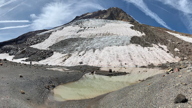
Newton-Clark Glacier and tarn:

Spaceship Rock and The Football Field:

Mt Hood under Spaceship Rock:

Cooper Falls at sunrise:

Cooper Creek leading to Cooper Falls with Mt Jefferson at dawn:

Eliot Glacier:

Mooney Tarn:

Coe Glacier:

Co Pass at Co Rock and Glisan Glacier:

Mississippi Head and Mt Jefferson:

Illumination Rock and the South of Mt Hood and Crater Rock:

GoalTech and Clark Kent at the finish line at Timberline Lodge:

Timberline Trail in green, GoalTech's Mt Hood High Route in red:

GPS Track:
https://www.gaiagps.com/public/egqDaXAduPohRXhxIBqPgfJH
If you have ideas for improvement or corrections, please let me know. If you plan to do any or all of this, I'd request that you let me know so that I can share what I learned. The last thing I'd want is for someone to run into problems due to getting in over their head. This is extremely hard, taxing, and fraught with risk due to exposure, rock movement, falls, etc.
P.S. I got a little carried away with my "preview" (typical)
Happy Trails!
GoalTech