
I made up a word: Circumglac: To hike up and over a glacier, descending the other side.
Fascinating day! Found a shocking route up St Helens, a clean simple line that's worthy of a name, if not a page in a guidebook.
A few months ago, I was on Wormflows* for the first time, as a descent route. I noticed a ridge to my left (east) with a few climbers coming up the crest. I wanted to ascend that ridge, then loop over swift glacier and descend Wormflows again, just for fun, to see what it looked like with less snow, with intentions of staying closer to Swift Creek this time.
I knew what time it was when I got out of bed, but I vowed not to obsess over time on this trip, so I was oblivious to the time until I arrived at Chocolate Falls, where Loowit Trail crosses Swift Creek. It was dark. Oops; I started too early. I sat and ate/drank, repacked, played on my phone, until it was light enough to continue w/o headlamp (maybe 20 mins?).
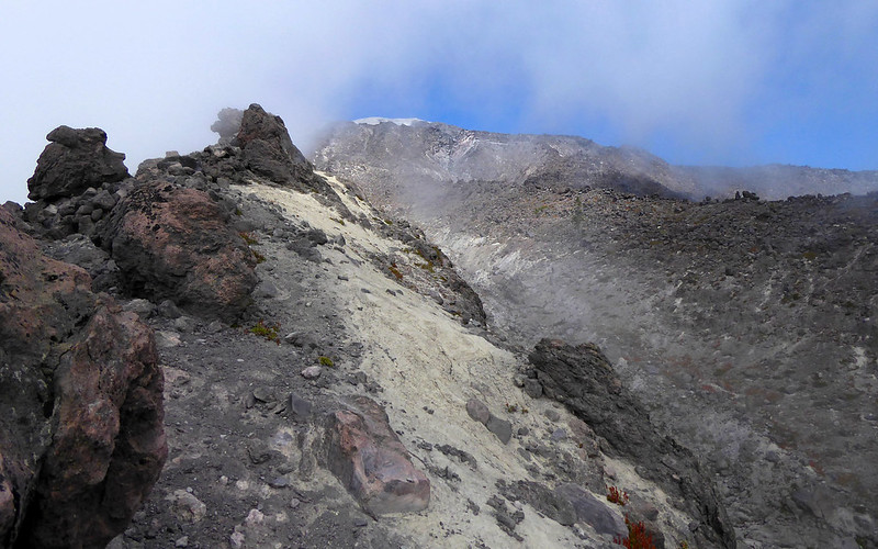
Started up the trail on the east side of Swift Creek, and broke off across the lava flow towards my ridge. It seemed so far away, and the terrain was so rugged, but I persisted. At the crest of my ridge, something changed radically: I'd been accompanied by the sound of Swift Creek tumbling down cascades and falls, but now there was a waterfall to my right/east, high up. My plan for the day shifted. I had to get there!
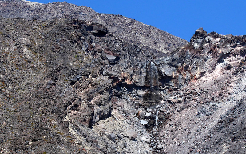
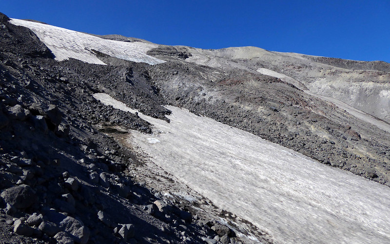
Looking up my ridge, I could see it faded into steep rubble, and it looked like the easiest route would be left/west, but that would take me farther from the falls. Surprisingly, as I ascended the ridge, the route to the falls and up to the top appeared do-able, so off I went. Soon, I could see the entire height of the falls, and the snow gully it fed. I was able to climb up to the top of the falls. I was confident that from the top of the falls I'd see snow above. I knew it could be a creek dropping through boring/dangerous rubble, but that seemed unlikely. I was right, just above the falls it was nothing but snow. Fantastic. How exciting!
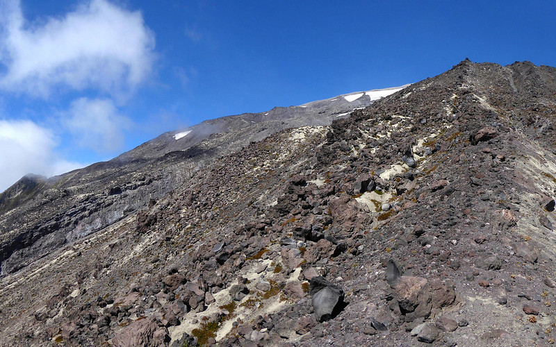
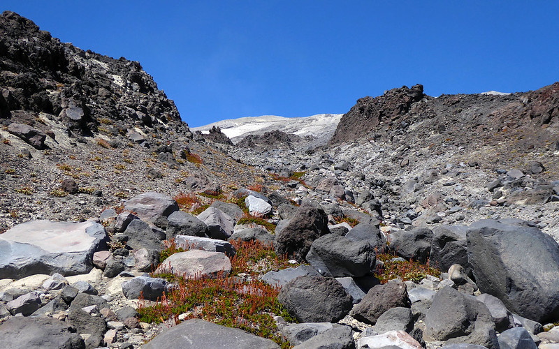
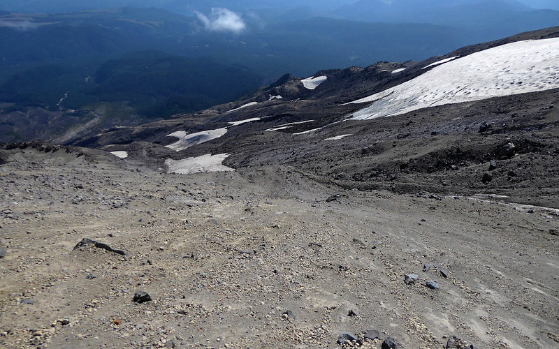
I crossed to the east side of the lip of the falls, and up to an overlook above the lip. From there I dropped a bit to the east and explored, visiting nice viewpoints. My progress was blocked by a steep/high ridge which I think I've already been on. I actually liked that; it provided a crisp well-defined end to my CCW exploring, forcing me back up and clockwise. Although there were a few options, I decided to return to the top of the waterfall, and I'm glad I did. I followed that snow up, and although it occasionally got pinched into narrow gullies, and it even gave way to cascades in a spot or two, the snow was essentially continuous all the way to a major snowfield that almost leads to the crater rim (maybe the last 100-200 ft are bare). This snowfield is big, maybe about the size of Swift Glacier to the west. But at that point, it was fairly boring, and I knew I didn't need to go all the way up to the top before traversing over to Wormflows route, so I started looking for opportunities to cross the ridge that defined the western edge of my snowfield.
When I gained that ridgecrest, I could see that I needed to cross a small gully to another ridgecrest. From there, I could finally look down into the Swift drainage. I was low though, and traversing towards Monitor Ridge would be tricky here, so I ascended that ridge until I could safely drop left/west onto Swift Glacier. That's about the time clouds came in. So much for easy routefinding. Through an abundance of caution, I traversed west and up, all the way to the loooong snowfield (part of Swift Glacier?) that runs parallel to Monitor Ridge, and followed it down. I knew I'd either have to follow Monitor down to Loowit Trail, or cut back to the east to regain the Wormflows/Swift route. Clouds dissipated, so I chose the latter.
Back at Chocolate Falls, where Loowit Trail crosses Swift Creek, I could still see the notch where my un-named waterfall spilled through. It's right there in plain sight, but too small for most hikers to notice as they stroll on by.
The last couple miles to my car (Marble Mountain) were sure to be miserable. I was looking forward to the solitude of a summer Wormflows hike, but no, there was a race in progress: The Volcanic 50, on "Mt St Helen’s" [sic]. On my descent of the last couple miles, I was passed by a racer. Well damn, I didn't like the way that felt, so I picked up the pace. Nobody else passed me, and I arrived at Marble Mountain to cheers and applause. "Oh, wait, he's not one of us," they soon grumbled (I imagine). How awkward! I was asked if I summited, but I was exhausted, and slightly drunk, so I blathered some nonsense about how summiting is for tourists. I probably sounded like an arrogant jerk, but oh well, I didn't have a statement prepared. Had I known my return to the TH would be under so many watchful eyes, I would have stumbled out of the woods holding a watermelon in one hand and a champagne flute in the other. Maybe next year.
*[Is it Wormflow? Wormflows? Worm Flow? Worm Flows? There's no agreement.]
St Helens: Swift circumglac
St Helens: Swift circumglac
- Attachments
-
- Snow just above my waterfall. hard to believe, but it's continuous all the way up to the big/high snowfield that almost reaches the crater rim.
-
- Looking down at my waterfall gap.
-
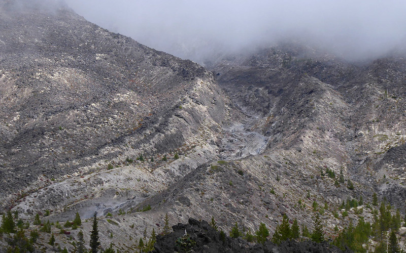
- The big snowfield on the right feeds my waterfall far below.
-
- Off snow now, moving west/CW.
-
- My first opportunity to look over at Swift Glacier. Skyline is Monitor Ridge.
-
- The last ridge I had to cross over. Had to climb up to the easy broad sandy slopes ahead, where I could easily drop off ridgecrest.
-
- I briefly popped up to the crest of Monitor Ridge to see some of the terrain I explored a couple days ago.
-
- Label says it's good for hot summer days. WEll, I thought it would be hot. What's a guy to do?
-
- Wormflows isn't the dry boring summer ascent you might imagine.
Re: St Helens: Swift circumglac
Oops, I forgot to post my overview pic. I blame sleep deprivation and beer. Left skyline is Monitor Ridge.
- Attachments
-

Re: St Helens: Swift circumglac
Wow, a friend pointed me towards this report, as I had just done almost the same route. I've been eyeballing that ridge for years now, thinking "one of these days...!" Finally did it on the 1st. It definitely needs a name! (Was thinking, maybe, "The Biggest Worm"? I dunno.) I didn't wander over to the falls, as it was barely flowing anymore, and stuck to either the ridge or the gully just to the east of it rather than hitting the snowfield. Not a terrible way up at all! I'll just add a few more photos of the alt-route...Chip Down wrote: ↑August 5th, 2018, 9:27 pmFascinating day! Found a shocking route up St Helens, a clean simple line that's worthy of a name, if not a page in a guidebook.
A few months ago, I was on Wormflows* for the first time, as a descent route. I noticed a ridge to my left (east) with a few climbers coming up the crest. I wanted to ascend that ridge, then loop over swift glacier and descend Wormflows again, just for fun, to see what it looked like with less snow, with intentions of staying closer to Swift Creek this time.
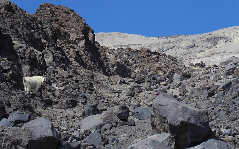
Wasn't sure where I was going, at this point.
Down to just a rapid trickle now.
Crumbly crap galore!
The gully became much easier to follow than the ridge at some point.
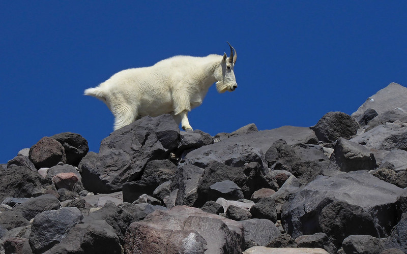
Then this happened.
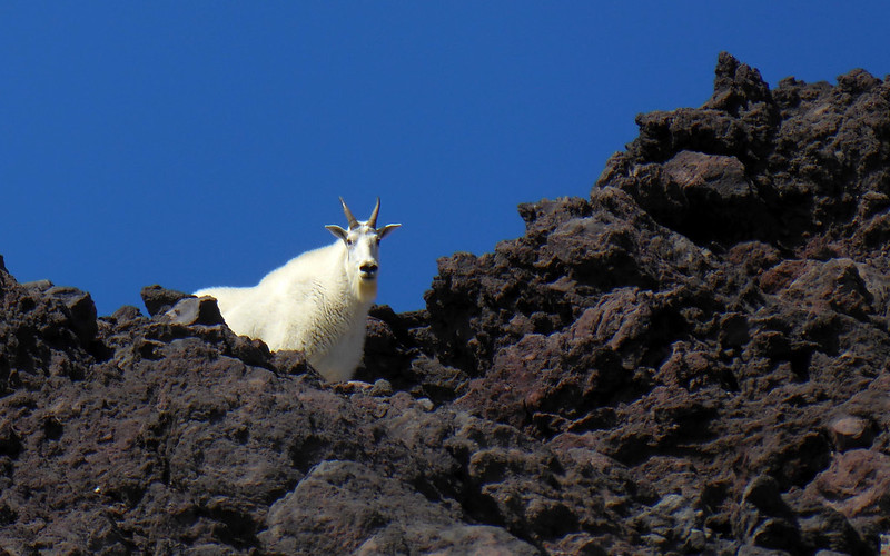
Seemed overly habituated for a MSH goat! Twenty minute standoff, before I could continue.
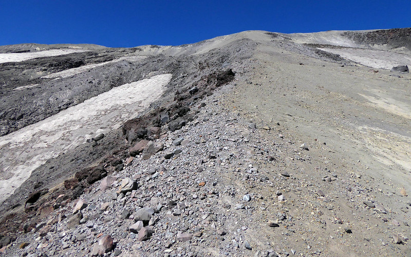
Ugh! 50% grade, on sand, to the rim. About 750' gained in last 1/4-mile.
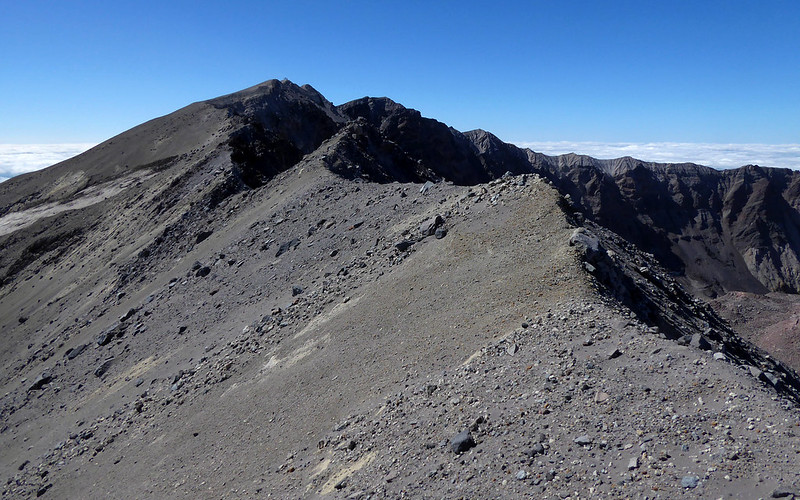
Tried rim-walking over to Monitor Ridge. Really, really dumb idea!
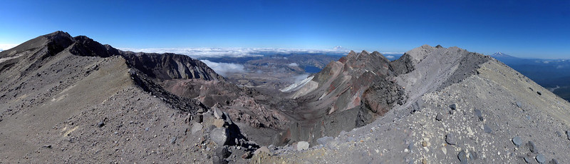
Isn't a crater rim pano obligatory?
My descent route, pretty much through the middle of this shot, straight towards Monitor Peak.
Looking back, I'd come from that bright high spot on middle-right.
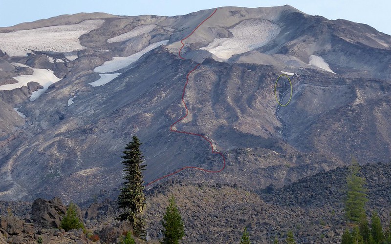
Actually shot this from Loowit Trail on 8/17, as I was eyeballing my eventual (red) route, and noted the falls then!
Definitely plural! I've always done used two words, rather than combine them, too.
Certainly two worms, there! Not sure if they're a result of two distinct flows, though?
It was a great day up there! Was alone the entire day. That winter route is stunningly different in summer! And yeah, the route up that ridge is certainly worthy of a name all its own.
Karl
Back on the trail, again...
Back on the trail, again...

Re: St Helens: Swift circumglac
Karl,
Thanks for posting! Two things in particular I was pleased to see:
The pic from Loowit Trail is enlightening. I wondered why it didn't look familiar, but then I remembered that the one time I've hiked that section, there was light precip, so perhaps the mountain was shrouded. [edit: checked my pics from that day; mountain wasn't shrouded, but it was early season, snowy, waterfall wasn't melted out yet.]
Great goat pics! I gather from your caption that he exhibited a bit of an aggressive territorial stance. I've found goats to be mildly averse to my presence, enough to amble away. Seems like the closer I am at the encounter, the more they stand their ground. Maybe alpinists should wear little bells to alert them.
Water,
I see what you did there (but surely nobody else did).
Re: St Helens: Swift circumglac
Bells wouldn't have helped. I was pretty cautious on approach, at first, in order to snap a photo or two. But it quickly became obvious he didn't care whether I was there or not. No real aggression, just an insistence that the gully was his until he was finished with it, and I could just damn well wait. Heh... After maybe five minutes, I started up a conversation, and kept it going for the next fifteen, until he finally moved along and allowed my passage.Chip Down wrote: ↑September 10th, 2018, 8:19 pmGreat goat pics! I gather from your caption that he exhibited a bit of an aggressive territorial stance. I've found goats to be mildly averse to my presence, enough to amble away. Seems like the closer I am at the encounter, the more they stand their ground. Maybe alpinists should wear little bells to alert them.
Buh bye!!!
First time I've seen one that habituated on MSH. Like you've experienced, they'll typically move along with very little encouragement there. Nope, this guy knew there was one more clump of little flowers still to munch, and was not gonna leave without chowing down!
He hung out on that ledge, which was directly above the gully I wanted to pass through, for at least five minutes. Curious about me, but seemingly unconcerned.
Karl
Back on the trail, again...
Back on the trail, again...
-
retired jerry

- Posts: 14424
- Joined: May 28th, 2008, 10:03 pm
Re: St Helens: Swift circumglac
I had a similar experience with goats in Enchantments. The goat came right up to me. I had to "shoo" it to get it to go away a bit.
Re: St Helens: Swift circumglac
Yeah, hear about them being aggressive, all the time, up there (and other places), but they've always been so skittish on MSH... This one was acting very out of character for this herd. My voice didn't concern him at all, and rocks may have been next had more persuasion became necessary.retired jerry wrote: ↑September 11th, 2018, 6:35 amI had a similar experience with goats in Enchantments. The goat came right up to me. I had to "shoo" it to get it to go away a bit.
Karl
Back on the trail, again...
Back on the trail, again...