
“One of the best mountain/lake views in Oregon”
7/22/17
Miles: 15.2
Time: 8 hrs, 0 min
Avg MPH: 1.9
Elev Min: 4,800’
Elev Max: 7,057’
Total Ascent: 2,525’
Steps: 36,600
Flights of Stairs: 170
Temp Low: 70
Temp High: 80
Other hikers: 2 at Fawn Lake at a distance
Longest time without seeing a hiker: 6 hours
Wildlife: None notable
Fawn Lake * Stag Lake * Lakeview Mountain * Saddle Lake * Odell Lake
Opening Shot: Lakeview Mountain from Stag Lake

This is a hike I’ve had my eye on for a whole year. There’s just something special about the hikes around Odell Lake since I spent my childhood here and have been here at least once a year for almost my entire life. As a kid I had no sense of the hiking possibilities and landmarks around here. I saw the mountains on the horizon like the moon, they were nice to look at and always there, but I had no concept to go hike around them or to climb them. So these hikes around Odell are little versions of my own personal “moon shot”…the ability to go explore what I’ve always seen, to see what they're all about.
The mountain today is 7,057’ Lakeview Mountain. This is an exposed peak that I can’t see from our cabin, but that I can see from out on the lake when we are waterskiing/wakeboarding each day. Here is a picture of Lakeview Mountain from the lake. This is a pretty special picture to add in here as this was taken in 1977, the year my parents bought our cabin.

I was excited that my cousin Todd and his son Kyler would join me on this hike. We had a couple of bail-out points, so we weren’t committing to the full hike...yet. We’d see how it went. At 1pm we started at the Crater Butte Trail No. 3844 at the railroad tracks behind the cabin. These tracks are also special as we spent many hours up here as a kid, running up from our cabin at the first sound of an approaching train. We’d smash pennies and dig in to the soft pumice dirt to make forts and other creations to play with in our imagination.

This first 4 mile section of trail goes to Fawn Lake. This was our classic hike growing up. It was the hike that everything else was compared to. We also cross-country skied this trail multiple times when growing up. It’s a pretty tame uphill hike rising 800’ over the 4 miles approaching the pretty Fawn Lake.

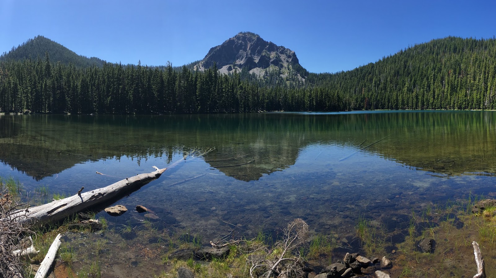
We were really feeling good with a fast pace so we continued on around the right side of the lake a 1/2-mile to another 1/2-mile spur trail to the right that led us to Stag Lake, which is a smaller lake that is 200’ higher than Fawn. Stag Lake was the perfect reflecting pool for Lakeview Mountain as you can see here.
We arrived just before 3pm and had traveled about 5 1/2 miles, so we were making really good time and felt great. Plus, that mountain looked SO close…right? Only a mile away as the crow flies! That was all it took to gently nudge Todd and Kyler into grabbing for the “brass ring” at the top of the peak.

Of course our tread was about to change as we went off-trail following a GPS route that I had mapped at home before the trip. It started off pretty well as we had to travel over some pretty easy up-sloping forest to get to the final approach to the mountain ridge. As we got close to the ridge-climb we could see our destination through the tree tops.

Up we went through the talus field. This was tough work for sure. It was pretty steep and required a lot of effort and care, but just less than too steep to worry about safety. We also wished we would have insisted that Kyler bring trekking poles as they were invaluable in this segment. Here is a picture back to Todd and Kyler making their way up the early portions of the ridge-climb.

The sights started to come into view as we could start to see the east end of Odell Lake where we started, Maiden Peak behind it and Odell Butte to the right.

But alas…there was still a ways to go…UP!

Finally we got to the ridge-line. But that was just a false summit for us. We needed to hang a right and go up the ridge-line to the summit. It turned out to be about 1,000’ of vertical in about 2/3 of a mile which is steep! The general average rule of thumb for mountain climbing is about 1,000’ per mile so we were really working hard! As we were working hard on the final summit approach I paused to catch my breath and look around…WOW! was I taken aback with my first view of 8,744’ Diamond Peak which was 5 miles away from us. You can also see Diamond View Lake in the lower left too which is on the Oregon Skyline Trail, whereas the Pacific Crest Trail travels roughly the timberline of Diamond Peak.

An hour and a half after leaving Stag Lake we were standing that mile away as the crow flies at the top of 7,057’ Lakeview Mountain.

The views were absolutely stunning. We could see Odell Lake in all its glory! That’s an unnamed pond in the foreground. The west end of Odell Lake is there with Willamette Pass Ski Area. You can barely see the tip of Mt Washington right above the summit of Willamette Pass’ Eagle Peak. Continuing to the right are the Three Sisters and Broken Top and then Maiden Peak.

I was so surprised to see the Three Sisters so close to us as I had no idea they were that close since I’ve never been up this high to see them this close to Odell Lake. Also, if you draw a line between the pond and the peak of Willamette Pass (in the picture above), then that line would intersect the approximate position in the middle of the lake where that picture from 1977 was taken.
Rotating to the right brought in the east end of Odell Lake with 6,987’ Maklaks Mountain in the back. Stag Lake can now be seen (from this side now) down below.

Pulling back a bit brought in the views next to Stag Lake of Fawn Lake and Crescent Lake.

Spinning around further to the right brought in the views from left-to-right of 8,196’ Howlock Mountain, 8,717’ Mt Thielsen, 7,592’ Cowhorn Mountain, 7,267’ Sawtooth Mountain and finally, 8,330’ Mt Bailey which is on the west shores of Diamond Lake, across from Mt Thielsen. A couple of years ago I hiked the Pacific Crest Trail along Diamond Peak, passing both Cowhorn Mountain and Mt Thielsen on the way to Crater Lake.

After enjoying the views and a snack for a a half-hour or so, we started down the steep route back to the saddle that we had climbed up earlier. I realized here that we should have swung wide on the way up and it would have been much less steep with less loose rock. Oops! Make a note of that if you ever do this hike. Here I am in the saddle, looking back at the summit.

Back up we went on the opposite side of the ridge-line, going back up about 1/2 the distance to our prior summit, to an unnamed peak at 6,892’. We dropped down its ridgeline on a pretty easy descent where it got greener and I saw my only lily on the hike, and it was a stunner.

We dropped off the ridge down an easy descent through the woods and finally met back up with the trail just before 6:30, almost an hour and a half after leaving the summit. Now we were on the freeway and really cruising down the easy downhill slope. This was good since we were low on water. It didn’t take long to get to Saddle Lake which at 6,230’ is about 600’ higher than Fawn Lake. We filtered and drank a bunch of water here before cruising another mile back to Fawn Lake.
We didn’t even stop to say hi to the lake as we were on a mission to get back to Odell with 4 miles to go. We motored quickly down the smoothly sloped trail to quickly get back to the cabin at 8:45pm, just before twilight. It was a remarkable hike and one that was 40 years in the making. I want to give a huge shout-out to my cousin Todd and his son Kyler as they were real champs with this adventure.

On a side note, I’m realizing that these off-trail adventures are so much less predictable with speed. I need to start building in even more buffer than I think. It’s kind of like predicting how long a DIY home improvement project will take! I’m equally bad at predicting both of those time frames. I think next year at Odell we’ll do the oft repeated and predictable “lake trail” as I need to make some amends with my relatives! Thanks for hanging with me!
Favorite experience of the day:
Seeing the incredible numbers of lakes and mountains from the summit of this remote peak and successfully route-finding our way to the top and spending it with family.
Least favorite experience of the day:
The climb up to the ridge was unexpectedly steeper than I thought, I should have gone wider on the approach, which also led to being later on our return which was unfair to all involved both on the hike and back at the cabin.
Today's route (right-to-left and back):

GoogleEarth from further away...

...and up close

Today's elevation: Look at that climb! Yikes!

GPS Track
https://www.gaiagps.com/public/vOndSPEZHWdUEh9V5pr2hSUX
-GoalTech (aka Mike)
www.GoalTechHikes.com
@goaltechhikes (Instagram)
