
After a brutally hot smoky week, I needed a high start and lots of snow to roll around in, so it was back to meadows again. I wanted to explore the steep terrain above A-Zone, on the edge of Heather Canyon, around the lower reach of Super Bowl. Then up to Steel Cliff (the east crater rim), and a few other little points of interest on the way down.
Butterflies were passing me on the way up, thick swarms in a hurry to get up the mountain. I'd say they were thickest at about 9000-9500', but there were still quite a few above 10,000'. Watch for them in my pics .
There will be a second set of pics in a few minutes.
Steel Cliff (Mt Hood's east crater rim)
Steel Cliff (Mt Hood's east crater rim)
- Attachments
-
- sunrise at a nice little meadow
-
- Here's the creek/snowfield from my sunrise pic, upstream, where the creek goes into the snowfield. This pic was from a previous trip. From a distance, I thought this looked like a nice spot to visit, and the portal told me there would be a creek. Kinda blew my mind when I saw the creek running the "wrong" way.
-
- Interesting portal.
-
- That steep cliffy area above A-Zone was my first goal.
-
- Above A-Zone. This was fun.
-
- No apparent need for an anchor here.
-
- This was the hardest most demoralizing part of the day. It was hot, I was tired, and it was very difficult to get enough traction to move up. It took tremendous will to get to that snow.
-
- Just a random picture, nothing to explain.
-
- Getting close. Could smell sulfur, and could see the summit. I was going to follow the edge of this rock, but nope, obviously not safe. Turned left and scrambled up rock to the rim.
Re: Steel Cliff (Mt Hood's east crater rim)
It was chilly up here. Not complaining.
- Attachments
-
- The yellow/tan rocks are on Steel Cliff. The dark heap is Crater Rock. The impressive grey monolith at lower left is Illumination Rock.
-
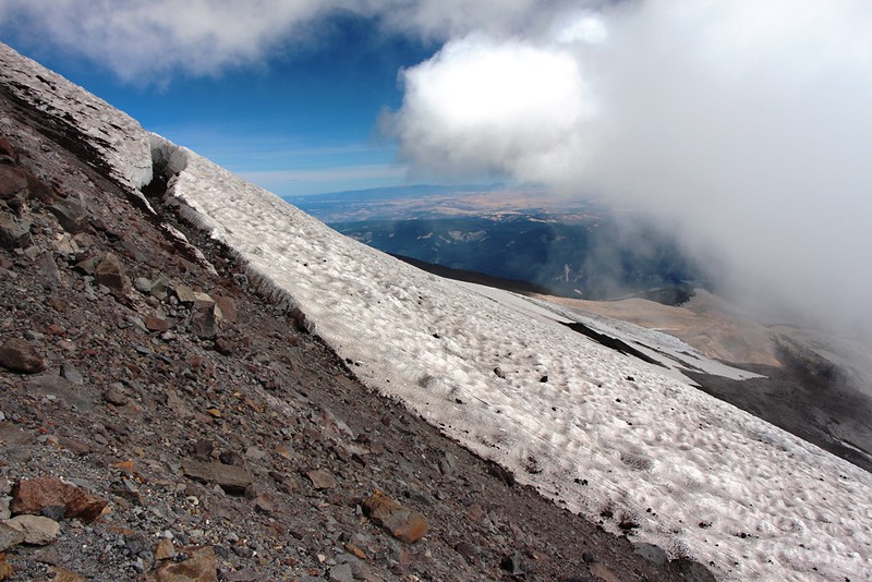
- Looking up from the south end of Steel Cliff. This picture doesn't adequately show how rugged the terrain is between Steel Cliff and summit. Nothing looks climbable, but I've done the Wy'East route which is up there somewhere. Maybe it's a little CCW and hidden, or maybe it's in this pic but easier than it looks.
-
- The last interesting viewpoint on the south end of Steel Cliff.
-
- Nice overview of the terrain between White River Canyon and Heather Canyon.
-
- I couldn't see the bottom, which told me it must get steeper down below. I was going down anyway, but after a few steps I realized it was just too soft, so looked for another way down.
-
-
- Ever open up a container of sunscreen or something at high altitude and it gushes a bit? You'd think a carbonated beverage would foam out as soon as the seal is broken, but it really wasn't that explosive.
-
BurnsideBob

- Posts: 538
- Joined: May 6th, 2014, 3:15 pm
- Location: Mount Angel, Oregon
Re: Steel Cliff (Mt Hood's east crater rim)
Gutsy "hike"! Congratulations on a job well done and looks like the views were spectacular.
Meadows clips a boundary sign into the anchors on that boulder when Super Bowl is open for hike skiing. Long arm of the ski patrol, ya know.
Meadows clips a boundary sign into the anchors on that boulder when Super Bowl is open for hike skiing. Long arm of the ski patrol, ya know.
I keep making protein shakes but they always turn out like margaritas.
Re: Steel Cliff (Mt Hood's east crater rim)
Those butterflies are unreal! I had no idea that went on up there. Are they there every year? How long does it last? How high do you have to climb to see them? (I don't think I can make it to 9000 feet.)
-
adamschneider

- Posts: 3716
- Joined: May 28th, 2008, 10:02 pm
- Location: SE Portland
- Contact:
Re: Steel Cliff (Mt Hood's east crater rim)
There are always a few California tortoiseshells — sometimes more than a few— but occasionally their population explodes, and this is one of those years.Webfoot wrote:Those butterflies are unreal! I had no idea that went on up there. Are they there every year? How long does it last? How high do you have to climb to see them? (I don't think I can make it to 9000 feet.)
For the record, I barely saw any on the east side of Hood at 7000' on Friday, so I'm guessing you'll have to go higher to get the crazy swarms.
Re: Steel Cliff (Mt Hood's east crater rim)
Bob: I was tempted to make a smartaleck remark about that anchor being related to the ski industry, but I didn't think it really was. And yeah, the views were cool. Didn't see anything I hadn't seen before, but it's good to get the overview, so you can really get a sense of how things fit together.
Webfoot: After scrutinizing my notes and pic data, I think my initial estimate was pretty close. They probably started around 8500', peaked around 9000-1000, and were thinner but still present in large numbers above 10,000.
Adam said he saw few around 7,000. The previous weekend I reported seeing large numbers starting maybe around 7300 to 7500ish, and fading above 8000.
I think time is a factor too, judging by the huge upward migration I observed. Of course, I have no idea how low they spent the night or when they started coming up, so I won't even speculate how low you could see the swarm.
-
BurnsideBob
- Posts: 538
- Joined: May 6th, 2014, 3:15 pm
- Location: Mount Angel, Oregon
Re: Steel Cliff (Mt Hood's east crater rim)
Once you clear the cliffy area above A-zone you come to this flat spot at 8,000 ft:
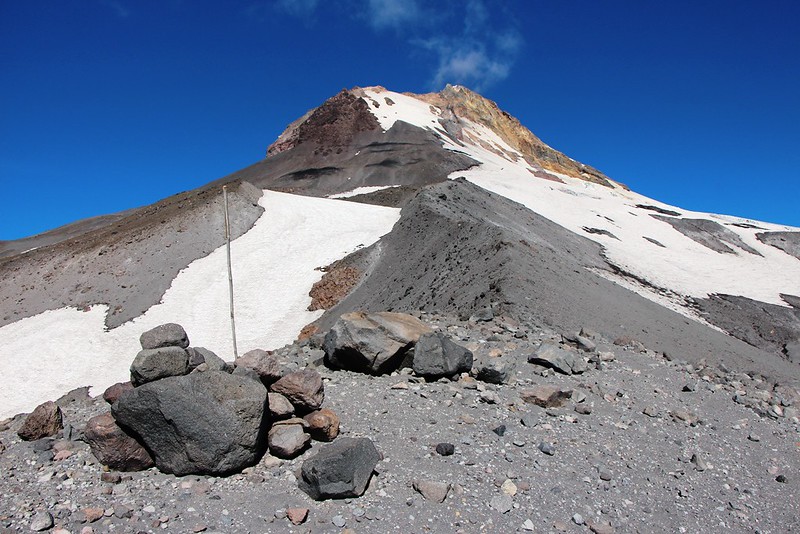
Mt Hood Meadows Ski Resort's permit area includes the terrain to the right of the ridge up to the bergshrund of the Newton Clark glacier at about 9,000 feet. Well, OK, there's a creep crack, but maybe this part is snow field, not truly glacier.
 Photos from 9/19/2014.
This part of the ski area, called 'Super Bowl' on the MHM trail map, is seldom open, but when it is patrollers are up there, hence my comment about "long arm" of the law. I've only seen one boulder with anchors, but with Meadow's penchant for signing things several wouldn't be a surprise. There used to be bamboo marker stakes stashed around that boulder, too.
I've experienced the butterfly migration a couple of times. What's amazing is they always fly up the ridges. So where do they go once they reach the top? Shouldn't there be down traffic somewhere?
Mt Hood Meadows Ski Resort's permit area includes the terrain to the right of the ridge up to the bergshrund of the Newton Clark glacier at about 9,000 feet. Well, OK, there's a creep crack, but maybe this part is snow field, not truly glacier.
Photos from 9/19/2014.This part of the ski area, called 'Super Bowl' on the MHM trail map, is seldom open, but when it is patrollers are up there, hence my comment about "long arm" of the law. I've only seen one boulder with anchors, but with Meadow's penchant for signing things several wouldn't be a surprise. There used to be bamboo marker stakes stashed around that boulder, too.
I've experienced the butterfly migration a couple of times. What's amazing is they always fly up the ridges. So where do they go once they reach the top? Shouldn't there be down traffic somewhere?
I keep making protein shakes but they always turn out like margaritas.
Re: Steel Cliff (Mt Hood's east crater rim)
If I recall a nature special correctly migrating monarchs travel thousands of feet above the ground; perhaps these butterflies do too?BurnsideBob wrote:I've experienced the butterfly migration a couple of times. What's amazing is they always fly up the ridges. So where do they go once they reach the top? Shouldn't there be down traffic somewhere?